
Changes In Dominant Streamflow Drivers As Network-Scale Flow Regime Shifts From Intermittent To Ephemeral Across A Multi-Year Drought
--
https://doi.org/10.1002/hyp.70413 <-- shared paper
--
#GIS #spatial #mapping #water #hydrology #fluvial #pluvial #precipitation #extremeweather #California #USA #semiarid #watershed #headwaters #weather #metrology #spatialanalysis #spatiotemporal #model #modeling #geostatistics #monitoring #sensors #instrumentation #insitu #drought #streamflow #ephemeral #intermittent #catchments #waterresources #watermanagement #watersecurity #planning
#coast #coastal #hydrogeomorphic #geology #climate
#Streamflow


Evaluating The Functional Realism Of Deep Learning Rainfall-Runoff Models Using Catchment Hydrology Principles
--
https://doi.org/10.1029/2025WR040076 <-- shared paper
--
#water #hydrology #surfacewater #pluvial #fluvial #rainfall #snow #snowmelt #runoff #precipitation #model #blackbox #robustness #functionalrealism #screening #parameters #accuracy #hydrologic #principles #trustworthy #modeling #spatialanalysis #spatial #mapping #GIS #spatiotemporal #USA #CONUS #AI #ExplainableAI #celerity #machinelearning #artificialintelligence #LSTM #deeplearning #evapotranspiration #waterresources #extremeweather #flood #flooding #risk #hazard #monitoring #prediction #catchments #streamflow #geomorphometry #network #flow #calibration


New Study Uncovers [Another Positive] Surprising Effect[s] Of Beavers' Dam-Building Behavior
--
https://www.yahoo.com/news/articles/study-uncovers-surprising-effect-beavers-193000239.html <-- shared technical / media article
--
https://doi.org/10.1111/1365-2656.70136 <-- shared paper
--
https://www.smithsonianmag.com/smart-news/beavers-are-dam-good-for-biodiversity-bringing-bats-butterflies-and-other-critters-to-their-neighborhoods-180987717/ <-- shared technical article
--
https://doi.org/10.1111/1365-2664.70193 <-- shared paper
--
#water #surfacewater #groundwater #hydrology #natural #beaver #wildlife #habitat #ecosystem #streamflow #beaverdams #geomorphology #montane #landscape #landforms #basin #watershed #drainage #spatial #reservoir #biodiversity #bat #butterfly #pollinators #pollination #insects #arthropods #food #feeding #predation #trees #vegetation #switzerland #night #day #nightandday #sampling #remotesensing #diversity #deadwood #spatialanalysis #LiDAR #ecology #aquatic #terrestrial #ecosystemengineering #model #modeling #structuralequationmodel #SEM #species #foodsecurity #biology #wetland #butterfly #bee #hoverfly #moth


Process-Based Hydrologic Model Representations of Non-Perennial Streamflow in the Pacific Northwest, USA
--
https://doi.org/10.1029/2025WR040626 <-- shared paper
--
https://www.pnnl.gov/projects/distributed-hydrology-soil-vegetation-model <-- shared @PNNL Distributed Hydrology Soil Vegetation Model overview page
--
#water #hydrology #PNW #PacificNorthwest #USA #perennial #ephemeral #streamflow #processbased #model #modeling #fluvial #pluvial #extremeweather #network #flow #lowflow #noflow #VariableInfiltrationCapacity #PrecipitationRunoffModelingSystem, #NationalWaterModel #NWM #streamgages #ecology #biogeochemical #humanimpacts #research #waterresources #watermanagement #rivers #streams #conservation #hydrogeomorphology #regulations #climate


Identifying Baseflow Source Areas Using Remotely Sensed and Ground-Based Hydrologic Data and Models
--
https://doi.org/10.1002/hyp.70322 <-- shared paper
--
#water #hydrology #SierraNevada #California #baseflow #source #snowpack #precipitation #fluvia #pluvial #GIS #spatial #mapping #remotesensing #waterresources #watermanagement #model #modeling #rainfall #recharge #groundwater #streamflow #snowmelt #elevation #spatialanalysis #spatiotemporal #extremeweather #climatechange #mountain #aquifer #watersecurity #hydrologicmodel #earthobservation


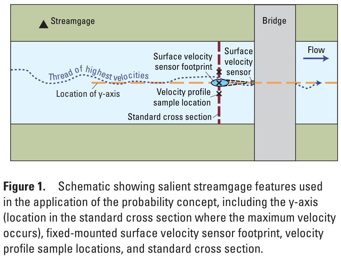
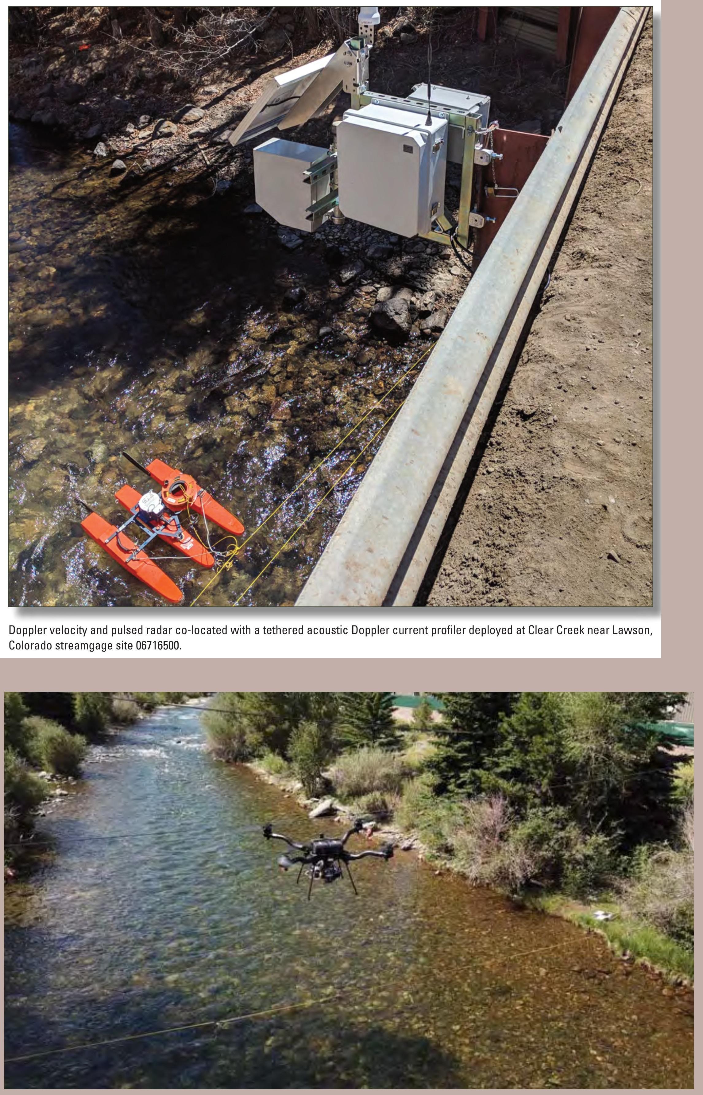
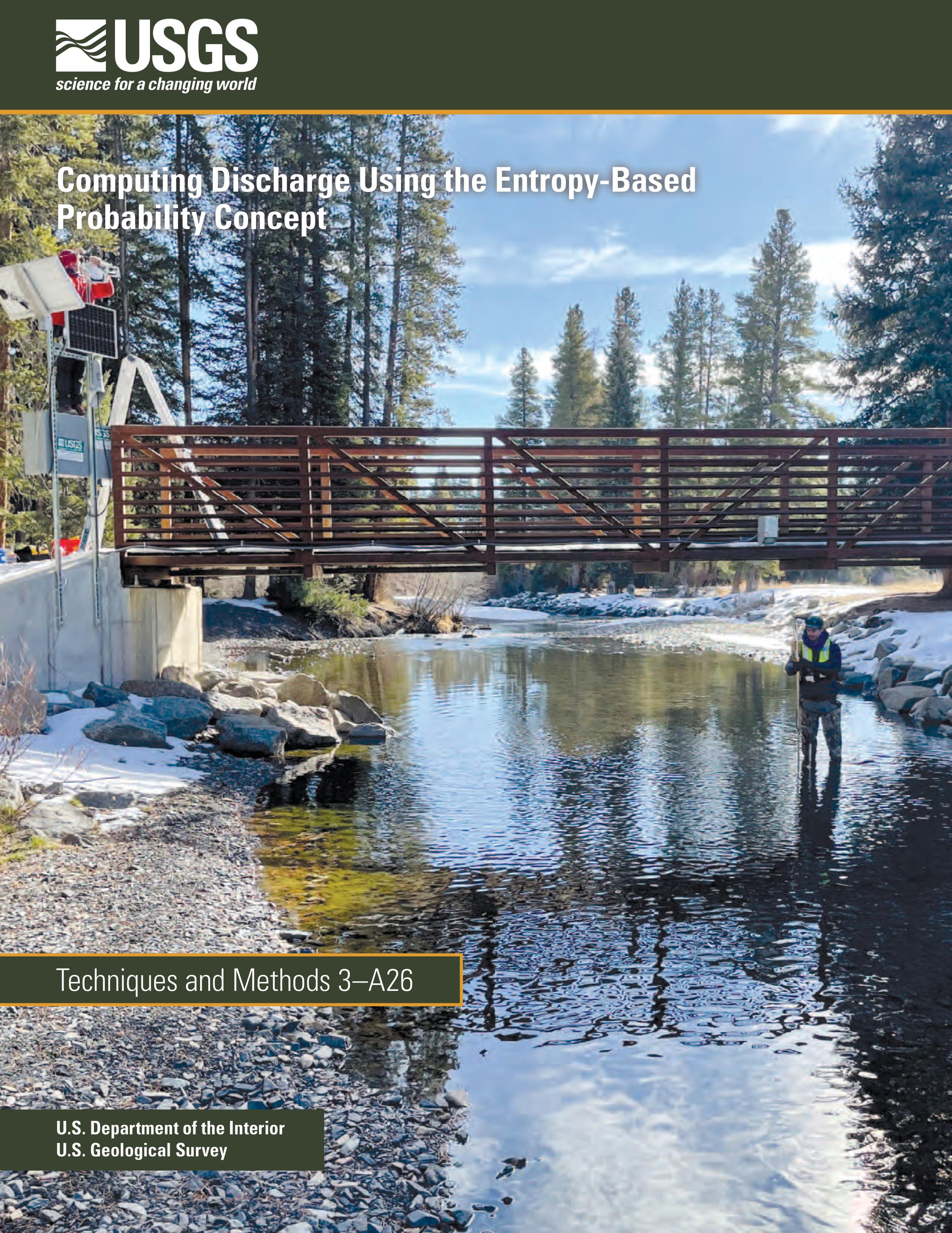
Computing Discharge Using the Entropy-Based Probability Concept [#USGS]
--
https://doi.org/10.3133/tm3A26 <-- shared USGS publication
--
"... PLAIN LANGUAGE SUMMARY: This report describes the steps and the theory to compute the speed and flow of water in streams using the probability concept…”
#water #hydrology #monitoring #measurement #calculation #estimation #discharge # computation #EntropyBasedProbability #probabilityConcept #research #testing #meanchannelvelocity #USGS #streamgaging #channelvelocity #metrology #season #USA #streamflow #timeseries #hydrospatial #spatial
@USGS

Have You Ever Wondered What A New Concrete Stilling Well [stream gauge] Looked Like?
--
H/T Roy Socolow, USGS
"While doing research on the USGS stream gaging program for a local presentation, [he] found this beautiful image of a classic stilling well from the Kentucky archives. Intakes and valve stems in perfect condition, hand pump and flush tank ready to fill, no kerosene or funky well water smell, and the clock weights on the Stevens recorder have plenty of travel room. Makes them] think of the good old days climbing down well ladders to “muck out” wells. Many of these “tanks” of instrument shelters still exist with either working intakes or as converted bubble gages. Many others have been decommissioned due to safety issues (falling or confined space hazards). Thanks to the men of the #CCC and #WPA..."
#gage #streamflow #instrumentation #hydrology #measurement #history #waterresources #stillingwell #recording #USGS #fedscience #fedservice
@USGS

Estimating Increased Transient Water Storage With Increases In Beaver Dam Activity
--
https://doi.org/10.3390/w16111515 <-- shared paper
--
“Dam building by beaver (Castor spp.) slows water movement through montane valleys, increasing transient water storage and the diversity of residence times. In some cases, water storage created by beaver dam construction is correlated to changes in streamflow magnitude and timing. However, the total amount of additional surface and groundwater storage that beaver dams may create (and, thus, their maximum potential impact on streamflow) has not been contextualized in the water balance of larger river basins..."
#water #surfacewater #groundwater #infiltration #river #basin #hydrology #natural #beaver #wildlife #habitat #ecosystem #waterstorage #waterresources #waterbalance #streamflow #snowwaterequivalent #snowmelt #beaverdams #geomorphology #montane #landscape #landforms #basin #watershed #drainage #HAND #spatialanalysis #spatiotemporal #model #modeling #spatial #MODFLOW #reservoir


This map shows normal 7-day average streamflow compared to historical streamflow for September 18. The areas in oranges and reds indicate very low streamflows.
Map of real-time streamflow compared to historical streamflow for September 19. The Northeast, Northwest and Hawaii are some parts of the U.S. with record low streamflows. Parts of the Great Plains have much above normal flows.
The map of below normal 7-day average streamflow compared to historical streamflow indicates areas where streamflow is much below normal.
Peak Streamflow Trends In Montana And Northern Wyoming And Their Relation To Changes In Climate, Water Years 1921–2020
--
https://pubs.usgs.gov/publication/sir20235064G <-- shared USGS publication
--
#water #hydrology #fedscience #climatechange #mapping #GIS #spatial #spatialanalysis #Montana #Wyoming #gage #streamgage #model #modeling #stream #river #watershed #streamflow #waterresources #management #planning #forecasting #statistics #geostatistics #flood #flooding #extremeweather #rainfall #precipitation #spatiotemporal #climate #climatechange #hydroclimate
@USGS
Water Data Keep Us Strong | USGS WaterAlert Water Safety at Your Fingertips [USGS Water]
--
https://www.usgs.gov/media/images/water-data-keep-us-strong and https://www.usgs.gov/media/images/usgs-wateralert-water-safety-your-fingertips <-- shared pair of USGS water-related infographics
--
https://accounts.waterdata.usgs.gov/wateralert/ <-- shared link to subscribe to USGS Water Alert
--
#water #hydrology #fedservice #fedscience #watersecurity #infographics #infographic #opendata #data #GIS #spatial #mapping #US #USA #alert #risk #hazard #monitoring #notification #waterdata #usecase #farms #agriculture #businesses #industry #residential #cost #economics #vitalresource #damage #assesr #resource #energy #HEP #watersupply #waterresources #management #planning #education #awareness #national #nation #WaterAlert #alerts #flows #streamflow #river #streamgauge #notification
@USGS


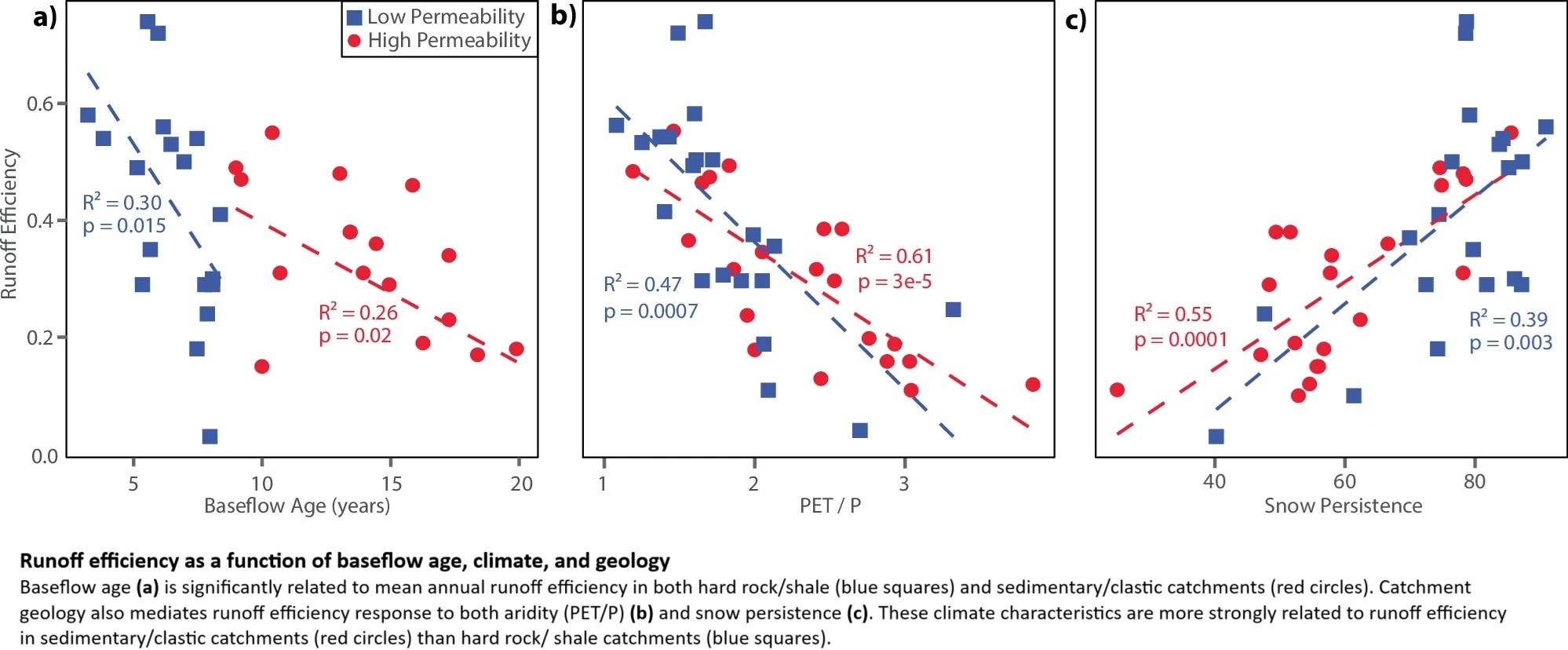
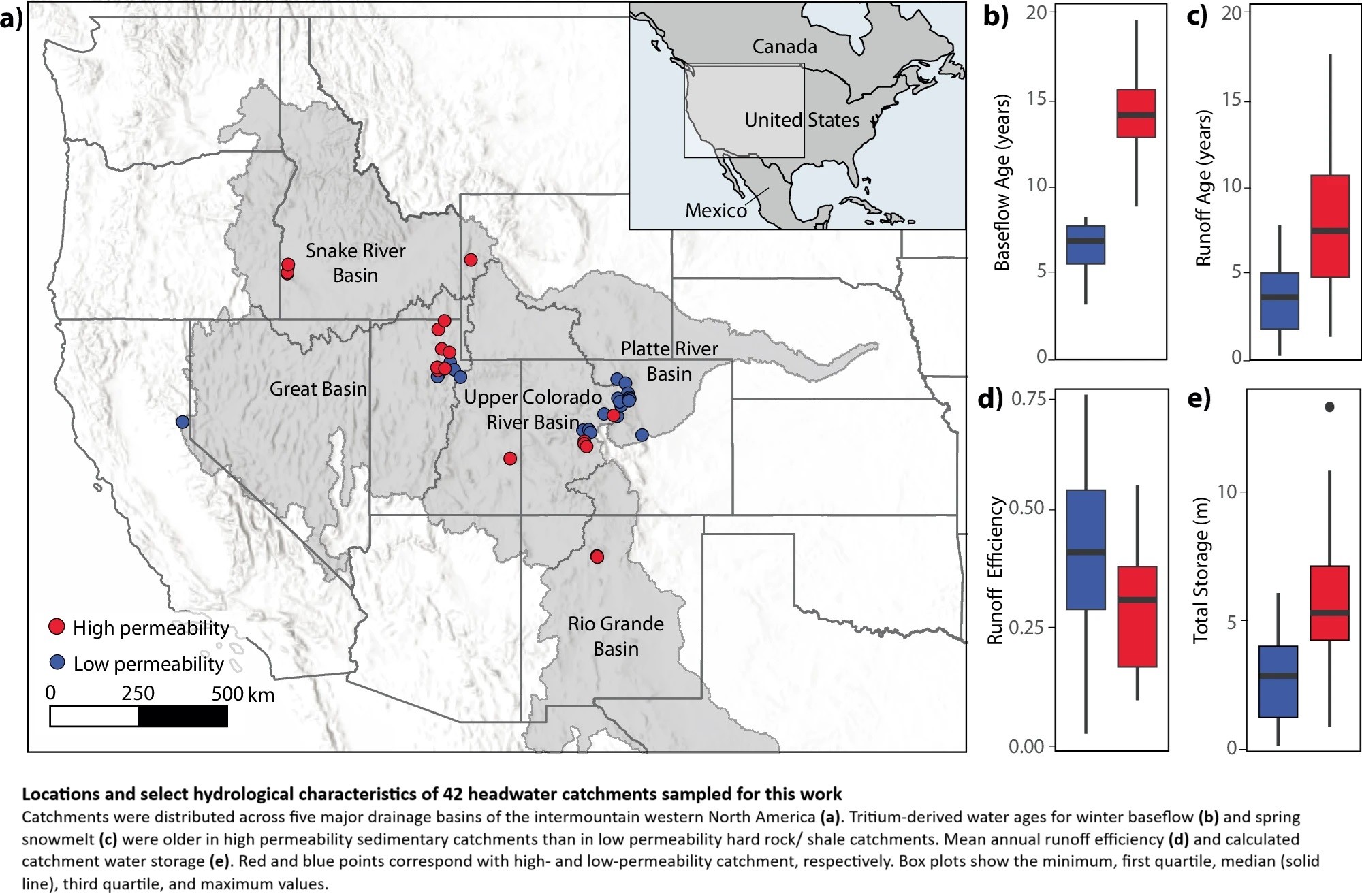
Groundwater Dominates Snowmelt Runoff And Controls Streamflow Efficiency In The Western United States
--
https://doi.org/10.1038/s43247-025-02303-3 <-- shared paper
--
#GIS #spatial #mapping #water #hydrology #fedscience #climatechange #snowmelt #waterresources #watersupply #management #planning #watersecurity #USWest #Rockies #snow #winter #mountain #catchment #dating #tritium #spatialanalysis #spatiotemporal #runoff #streamflow #infiltration #model #modeling #geology #geomorphology #groundwater #storage #surfacewater #streamwater #precipitation #bedrock #soils #sediments #permability #porosity #watershed #subsurfaceflow #storage #climate #future #landscape


USGS Water Data Centers May Soon Close, Threatening States’ Water Management
"Across the country, the data collected at stream gauges managed by the U.S. Geological Survey are used to implement drought measures when streamflows are low, alert local authorities of floods, help administer water to users on rivers and issue pollution discharge permits required by the Clean Water Act for communities across the country."
But more than two dozen USGS Water Science Centers that house the employees and equipment to manage those gauges and equipment will soon have their leases terminated after being targeted by the Department of Government Efficiency. Data collected by the centers inform studies of the condition of the country’s water resources and shape local and state water management plans.
A Framework For Understanding The Effects Of Subsurface Agricultural Drainage On Downstream Flows
--
https://doi.org/10.3133/sir20255023 <-- shared USGS publication
--
#water #hydrology #mapping #framework #model #modeling #fedscience #streamflow #subsurface #soil #drainage #agriculture #farming #landuse #landcover #GIS #spatial #tiledrainage #drains #flow #waterresources #runoff #peakflow #evapotranspiration #precipitation #USA
@USGS


Evaluating Drought Risk Of The Red River Of The North Basin Using Historical And Stochastic Streamflow Upstream From Emerson, Manitoba
--
https://pubs.usgs.gov/publication/sir20255002 <-- shared link to USGS publication
--
https://waterdata.usgs.gov/nwis <-- USGS National Water Information System (NWIS) database - USGS water open data for the Nation
--
#GIS #spatial #mapping #deterministic #waterbalance #stochasticweather #model #modeling #RedRiver #USA #Canada #spatialanalysis #spatiotemporal #waterresources #streamgage #NorthDakota #Manitoba #streamflow #flood #flooding #watersupply #agriculture #farming #ecology #drought #extremeweather #meteorology #basin #subbasin #risk #hazard #gauge #flow
@USGS


NOAA/USGS Water Map – National Water Model
--
https://water.noaa.gov/map <-- shared web map
--
https://water.noaa.gov/about/nwm <-- shared NWM ‘About’ page
--
[ the post’s author did the spatial analysis to get the first round of elevation values of the majority of the 10s of millions offshore points, etc - http://alturl.com/3nrbm ]
#GIS #spatial #mapping #model #modeling #NationalWaterModel #NOAA #NWM #FIM #water #hydrology #framework #streamflow #realtime #observed #watercycle #rainfall #precipitation #snowmelt #overlandflow #flood #flooding #floodinnundationmodel #FIM #infiltration #bigdata #supercomputer #risk #hazard #mitigation #warning #warningsystems #threat #guidance #NationalWeatherService #forecast #forecasting #meteorology #river
@NOAA @USGS @nws


New Study Tracks The 100,000-Year Journey Of Underground Water
--
https://scitechdaily.com/new-study-tracks-the-100000-year-journey-of-underground-water/ <-- shared technical article
--
https://doi.org/10.1038/s44221-024-00366-8 <-- shared paper
--
[there is an old saw along the (flow)lines of "Surface water is just the expression of groundwater on the land"]
#GIS #spatial #mapping #water #hydrology #subsurface #groundwater #watercycle #waterresources #streamflow #surfacewater #connection #model #modeling #CONUS #USA #baseflow #sediments #aquifers #alluvium #flow #waterresources #subbasins #watershed #climatechange #contamination #rainfall #precipitation #snowmelt #continental
![schematic - Here [they] quantify the extent of groundwater–stream connections over the continental United States](https://files.mastodon.social/cache/media_attachments/files/113/828/604/325/953/971/original/cafb4d4203953efc.jpg)


Why Isn't Colorado's Snowpack Ending Up In The Colorado River? Research Suggests It Might Be The Lack Of Spring Rainfall
--
https://phys.org/news/2024-08-isnt-colorado-snowpack-river-lack.html <-- shared technical article
--
https://dx.doi.org/10.1029/2024GL109826 <-- shared paper
--
#GIS #spatial #mapping #ColoradoRiver #ColoradoRiverBasin #water #hydrology #snowpack #rainfall #spring #precipitation #waterresources #waterbalance #watermanagement #climatechange #sublimination #headwaters #streamflow #model #modeling #spatialanalysis #spatiotemporal #plants #vegetation


Client Info
Server: https://mastodon.social
Version: 2025.07
Repository: https://github.com/cyevgeniy/lmst