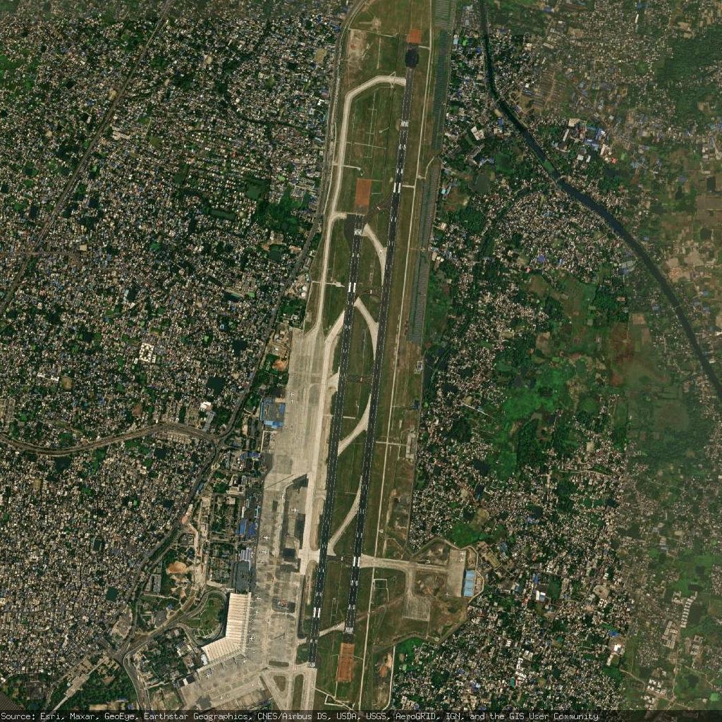
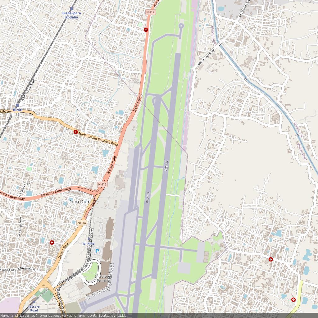
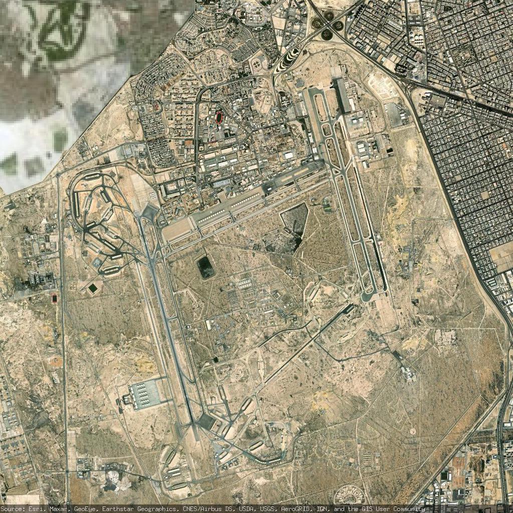
Netaji Subhash Chandra Bose International Airport - Kolkata, India
https://en.wikipedia.org/wiki/Netaji_Subhash_Chandra_Bose_International_Airport
https://www.openstreetmap.org/#map=13/22.654699/88.446701
Netaji Subhash Chandra Bose International Airport - Kolkata, India
https://en.wikipedia.org/wiki/Netaji_Subhash_Chandra_Bose_International_Airport
https://www.openstreetmap.org/#map=13/22.654699/88.446701
Might as well do an #introduction post as it has been a while...
Hello there Fediverse! I am an environmental archaeologist interested in how past communities interacted with and shaped their environments (and vice versa). Just finished my #PhD (Physical #Geography at #Plymouth) focusing on the #HumberheadLevels. For my thesis, I combined #pollen analysis, #GIS, and #geoarchaeology to understand relationships between people and #wetland #landscapes. I recently passed my viva, so I am currently looking for work.
My published work thus far includes contributions on land cover reconstruction in complex wetland systems and chapters on #anarchist approaches to #archaeology and #heritage practice. I have a few more pieces in the works, and little time to do them all.
As far as research goes, I have been mostly interested in challenging the 'pristine #nature vs human impact' binary, the politics of how we interpret past landscapes, and unpicking what we actually mean when we talk about 'natural' environments and the messy reality of human-environment coevolution.
Reviving this account to catch up with your lovely faces and to see what's happening in #archaeology #paleoecology #gis #wetlands #politicalecology and related fields. 💗
I've passed my #viva (yay!) and can now share two recent publications:
First, our article on reconstructing prehistoric land cover in the Humberhead Levels is now out in Vegetation History and #Archaeobotany.
We applied the Multiple Scenario Approach to produce spatially-informed quantitative reconstructions across four #prehistoric periods, working through the complexities of #wetland-rich 'blue-green' #landscapes where #freshwater and #marine systems intersect.
https://link.springer.com/article/10.1007/s00334-026-01087-6
Second, I contributed to the #archaeology chapter in The Palgrave Handbook of #Anarchism (March 2026), which connects #anarchist theory and #history to contemporary political developments.
https://link.springer.com/book/9783031980299
More publications on the way as well and on to what comes next, whatever that might be (pls send me your #postdoc postings 🙏 😅 ).

Programming Basics for QGIS Users
--
https://courses.gisopencourseware.org/course/view.php?id=80 <-- shared GIS OpenCourseWare resource
--
#tutorial #training #onlinelearning #course #stepthrough #GIS #spatial #mapping #QGIS #scripting #coding #programming #development #automation #customisation #workflows #automating #Python #PyQGIS #spatialanalysis #commandline #tools #opensource
@MITOpenCourseWare


Monitoring Snow Cover Dynamics At 30-M Resolution In Higher Latitude Regions Using Harmonized Landsat Sentinel-2 [Canada & Alaska]
--
https://doi.org/10.1016/j.isprsjprs.2026.01.032 <-- shared paper
--
https://app.geo.ca/en-ca/map-browser/record/1ed7fdec-9a50-4fe9-aa16-78f9ee3f05bc <-- shared dataset
--
#GIS #spatial #mapping #snow #snowcover #arctic #Arctic #highlatitude #harmonized #Landsat #Sentinel2 #Sentinel #remotesensing #imagery #earthobservation #HudsonBat #BrooksRange #ecozone #snowdynamics #spatialanalysis #spatiotemporal #metrics #winter
@NRCAN


Map-Based, Online Dashboard - St. Vrain and Left Hand Water Conservancy District
--
https://dashboard.svlh.gov/ <-- shared dashboard
--
https://svlh.gov/ <-- shared St. Vrain and Left Hand Water Conservancy District home page
--
H/T @st. Vrain and Left Hand Water Conservancy District
#waterconservancy #watermanagement #waterdata #knowyourwatershed #water #hydrography #hydrology #FrontRange #Colorado #USA #GIS #spatial #mapping #openscience #spatialanalysis #waterresources #watermanagement #alldataisspatial #spatialdata #LeftHandCanyon #StVrain #visualisation #wateruser #landowner #partner #industry #ecology #ecosystem #watershed #waterquality #watersecurity
@st. Vrain and Left Hand Water Conservancy District


Catania-Fontanarossa Airport - Catania, Italy
https://en.wikipedia.org/wiki/Catania-Fontanarossa_Airport
https://www.openstreetmap.org/#map=13/37.466801/15.066400

Mexico map showing Land cover 🇲🇽 From tropical forests to desert shrublands — one of Earth's most biodiverse nations.
🗺️ Hemed Juma Lungo | GLC2000
#GISChat #Mexico #LandCover #GIS #Cartography #RemoteSensing #Biodiversity

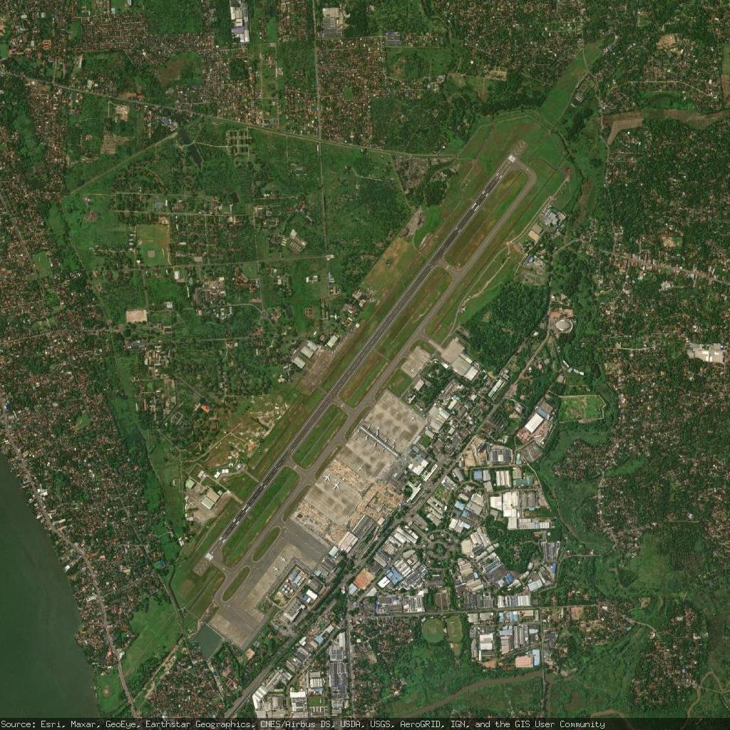
Tocumen International Airport - Tocumen, Panama
https://en.wikipedia.org/wiki/Tocumen_International_Airport
https://www.openstreetmap.org/#map=13/9.071360/-79.383499
#MPTO #PTY #Tocumen #Panama #airport #aviation #avgeeks #GIS


Buchen Sie den Mapbender-Workshop auf der #FOSSGIS2026 in Göttingen im März 2026
http://fossgis-konferenz.de/2026
👉 Einführung in Mapbender
Donnerstag 26. März 2026
11:10 Uhr | 1,5 Stunden
Trainerinnen: Astrid Emde & Thekla Wirkus
Der Workshop zu Mapbender hilft beim Einstieg und bietet einen sehr guten Überblick über die Einsatz- und die Konfigurationsmöglichkeiten der WebGIS-Client-Suite.
https://pretalx.com/fossgis2026/talk/M7JQQW/
Astrid Emde & Thekla Wirkus

ebook: Manager’s Guide: #AI and #GIS: Where to start? https://tinyurl.com/4kvkej52 by
@esricanada
#GenAI #models #GIS #esri #arcgis #GISchat #geospatial @esri @esrifederalgovt @esrislgov @esritraining @urisa

Recently, our first-year GeoTech students visited Direção-Geral do Território (DGT) to explore how geospatial data supports land management and spatial planning. 🗺️
During the visit, students were introduced to both historical and modern technologies, gaining insights into applications of geodesy, cartography, and web-based geospatial services.
We would like to thank the DGT team for sharing their expertise. ✨


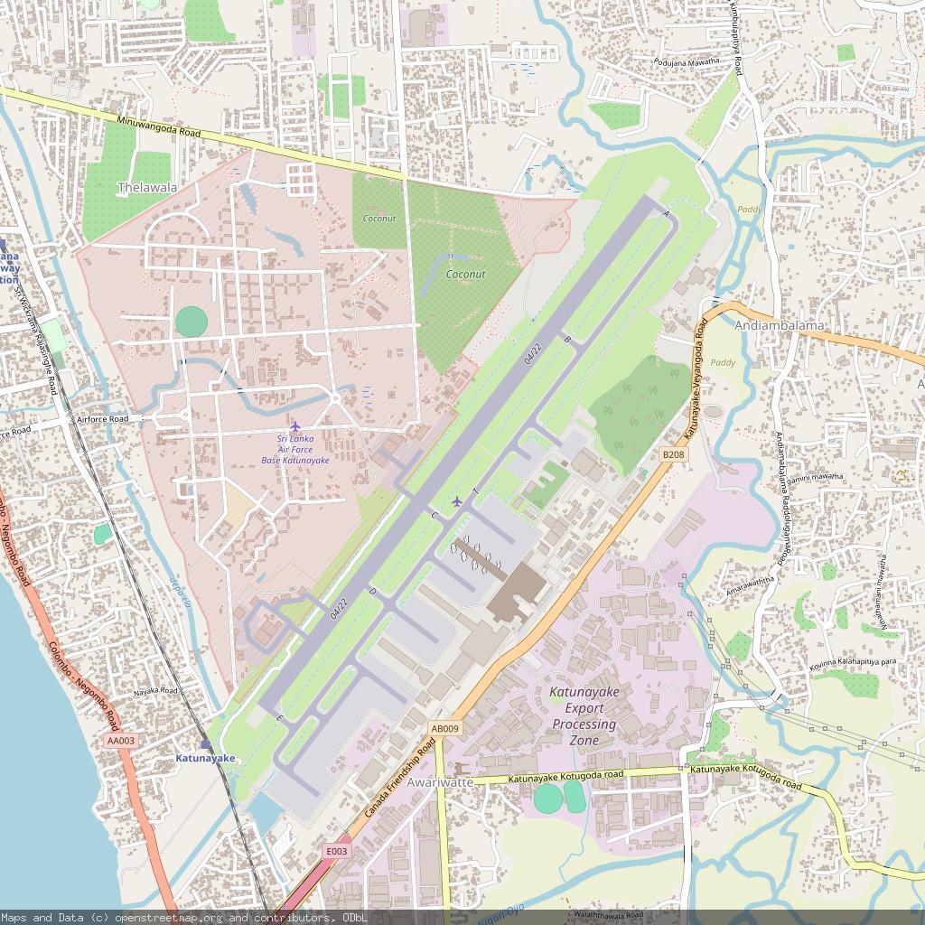
Bandaranaike International Colombo Airport - Colombo, Sri Lanka
https://en.wikipedia.org/wiki/Bandaranaike_International_Airport
https://www.openstreetmap.org/#map=13/7.180760/79.884102
#VCBI #CMB #Colombo #SriLanka #airport #aviation #avgeeks #GIS
#winter #weather
yes, it rains in Spain!
here's a lovely bit of #opendata for #openlearning
https://view.eumetsat.int/
#geomapping #gis #eumetsat
Geospatial Conference Scheduler 2026 https://geoobserver.de/2026/02/03/geospatial-conference-scheduler-2026/ #Geospatial #Conference #Scheduler #gistribe #gischat #fossgis #foss4g #OSGeo #spatial #gis #geo #geoObserver pls RT

King Abdulaziz Air Base - Dhahran, Saudi Arabia
https://en.wikipedia.org/wiki/King_Abdulaziz_Air_Base
https://www.openstreetmap.org/#map=13/26.265400/50.152000
#OEDR #DHA #Dhahran #SaudiArabia #airport #aviation #avgeeks #GIS

Geosurvey Reveals Hidden Australia Magnetic Anomaly
--
https://www.csiro.au/en/news/All/Articles/2026/January/Australia-magnetic-anomaly <-- shared CSIRO (Australia) technical article
--
https://research.csiro.au/potential-fields/ <-- shared CSIRO ‘Potential Field Geophysics’ home page
--
https://www.sciencebase.gov/catalog/item/6193e9f3d34eb622f68f13a5 <-- shared @USGS tri-national (Canada, USA and Australia) geologic, geophysics, and mineral resource data release / report
--
https://www.ga.gov.au/scientific-topics/disciplines/geophysics/airborne-electromagnetics <-- shared Australian government airmag overview page
--
https://doi.org/10.5382/Mono.06.30 <-- shared paper, “The Contribution Of High Resolution Aeromagnetics To Archean Gold Exploration In The Kalgoorlie Region, Western Australia”
--
#CriticalMinerals #GIS #spatial #Mapping #CriticalMineralsMappingInitiative #geology #structuralgeology #mineralresources #exploration #discovery #remotesensing #model #modeling #mining #economics #Australia #NorthernTerritory #MagneticAnomaly #AustraliaMagneticAnomaly #geomagnetism #openscience #opendata #openaccess #geoscience #geophysics #aeromagneticsurvey #aeromagnetic #spatialanalysis #CSIRO
@CSIRO


Hype for the Future 94G: The Road Network Explained
Introduction While novaTopFlex cannot provide up-to-date nor guaranteed information about road conditions in any particular location at any given date or time, the overall road network is of significant importance for identifying the geospatial interests of the Three Identities as appropriate. Geospatial Information Using geospatial data, crowd-sourced road network information, official government records, and information about highway routes of all types, the community can identify […]https://novatopflex.wordpress.com/2026/02/02/hype-for-the-future-94g-the-road-network-explained/
How many runways can you see for Gisborne airport (New Zealand) ? : The answer is on https://www.bigorre.org/aero/meteo/nzgs/en #gisborneairport #airport #gisborne #newzealand #nzgs #gis #aviation #avgeek vl
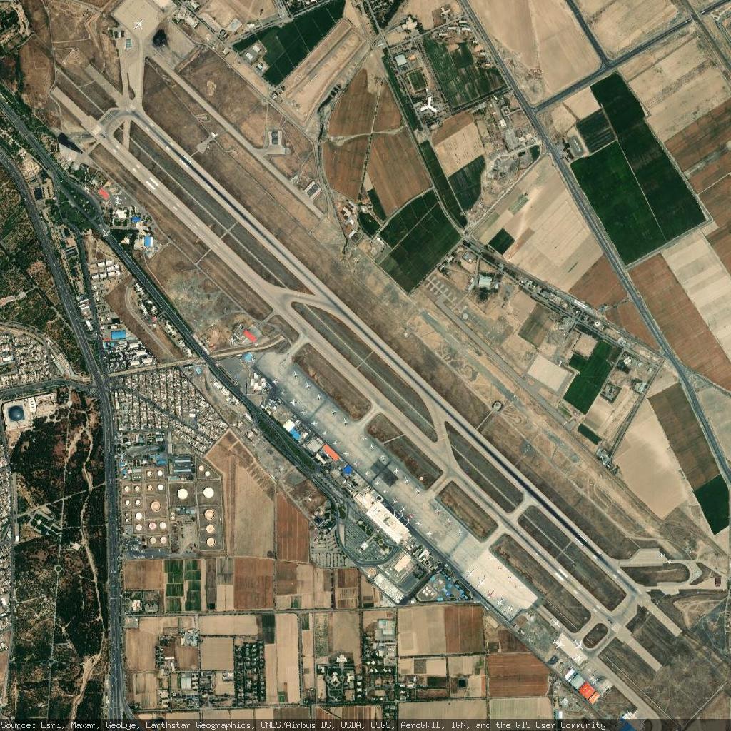
Mashhad International Airport - Mashhad, Iran
https://en.wikipedia.org/wiki/Mashhad_International_Airport
https://www.openstreetmap.org/#map=13/36.235199/59.640999