#GeoSpatial

Geospatial Technologiesgeotech_msc
2026-02-06

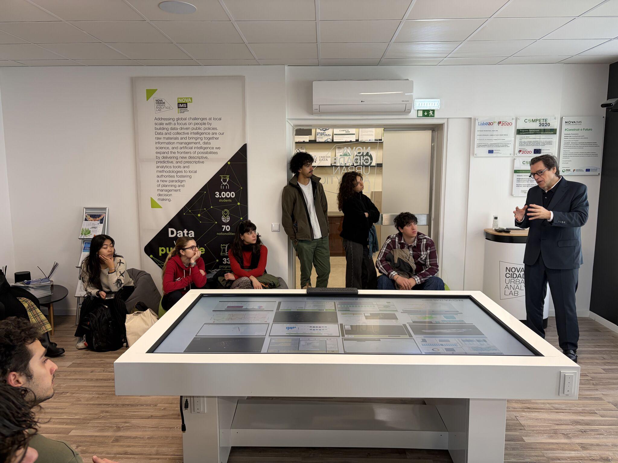
Recently, our first-year GeoTech students visited NOVA Cidade – Urban Analytics Lab at NOVA IMS to explore how data-driven analytics support cities and regions. 🌍

During the visit, students were introduced to a range of urban analytics applications and demonstrations, gaining insights into how geospatial data is used in urban and regional contexts. ✨

2026-02-06

#ArcGIS has a deployment pattern specifically designed to support #mobile #GIS! Learn more via the ArcGIS Well Architected Framework tinyurl.com/y65seks8

#GISchat #geospatial #enterpriseGIS #SolutionArchitect #bestpractices #esri @esri @esrifederalgovt @esrislgov @arcgisxprise @urisa

⌛️ Time's running out to apply for the #SOTMUS fellowship! Get your applications in by Friday, Feb. 6th! Details here: openstreetmap.us/news/2026/01/

#OpenStreetMap #StateoftheMapUS #Madison #geospatial #opendata #conference #GIS

2026-02-05

Vantor wins $5.3 million NGA contract to spot terrain changes using commercial satellite data

fed.brid.gy/r/https://spacenew

2026-02-05

Not missing - just misplaced! 📢 International research team, including WorldPop refute claims that 50% of rural populations are missing from maps. High-res data remains robust! 🗺️

Learn more: worldpop.org/blog/global-popul

#Geospatial #DataAccuracy #GlobalGoals

2026-02-04

1st year anniversary: One year ago today, I set out to curate geospatial news independently and openly with Spatialists.ch. A year, 164 posts, and countless discoveries later, it’s time to look back – and ask you about your feedback regarding this service for the geo...
spatialists.ch/posts/2026/02/0 #GIS #GISchat #geospatial #SwissGIS

QuarticleQuarticle
2026-02-04

Siloed datasets, slow processing, rising cloud costs, and manual spatial workflows make it hard to turn location data into reliable decisions at scale.

Quarticle solves this with a cloud-native, AI-ready GeoIntelligence suite built for performance, open integration, and full operational control.

Learn more: quarticle.ch/

FOSS Academyfoss_academy
2026-02-04

Erweitern Sie Ihre & Skills im März 2026! 🚀

📑 „Geodatenmanagement mit PostgreSQL/PostGIS":
- Einführung in PostgreSQL & PostGIS
- Geodatenmodell, SQL & Datenmanipulation
- Datenbankclients: psql, pgAdmin & QGIS
- Datenaustausch & Performanceoptimierung

📍 Online 📆 17. – 20. März 2026 (4 Vormittage)
🕙 jeweils 09:00 – 12:00 Uhr

👇 foss-academy.com/geodatenmanag

@wheregroup

2026-02-04

Wir gratulieren herzlich zum 20. Jubiläum der @osgeo Der @FOSSGISeV als deutschsprachiges Local Chapter ist Teil dieser wunderbaren internationalen Community.

Wir wünschen der #OSGeo alles Gute und eine weitere Verbreitung von #OSS für #Geospatial sowie ein gesundes Wachstum der Community mit vielen aktiven Menschen weltweit.
Eine Welt ohne OSGeo ist für uns nicht mehr denkbar.
osgeo.org

Interessante Infos findet Ihr im Geburtstagpost: h7.cl/1j5I0

#FOSSGIS #OSM

Bild zeigt einen Geburtstagsgruß des FOSSGIS e.V. an die OSGeo. Bild mit Luftballon und Schriftzug Happy Birthday in orange auf weißem Grund und das OSGeo-Logo und das FOSSGIS-Vereinslogo.
Text: 20 Jahre OSGeo! Wir gratulieren herzlich zum 20. Jubiläum der OSGeo. Der FOSSGIS als deutschsprachiges Local Chapter ist Teil dieser wunderbaren internationalen Community.  
Wir wünschen der OSGeo alles Gute und eine weitere Verbreitung von Open Source Software für Geospatial sowie ein gesundes Wachstum der Community mit vielen aktiven Menschen weltweit.
Eine Welt ohne OSGeo ist für uns nicht mehr denkbar. 
https://osgeo.org
OpenGeoHub Foundationopengeohub@fosstodon.org
2026-02-04

We are excited to come this year to Istanbul (Faculty of Aeronautics and Astronautics / Istanbul Technical University, 17—21 August 2026) - we expect more than 20 lecturers (contributors to Python, R, Julia open source #geospatial devs) and between 100-120 participants.
Send your PhD, Master level students and post-docs - help them join vibrant open development communities.
Previous 3 summer schools are available as video-recordings from: av.tib.eu/publisher/OpenGeoHub and youtube.com/@OpenGeoHubFoundat

Melike Nikbay Serkan Girgin Esra Erten Jakub Nowosad
Istanbul Technical University of Twente Istanbul Technical —
University University
Leandro Parente Furkan Celik Mustafa Serkan Isik Maarten Pronk
OpenGeoHub Foundation University of Twente OpenGeoHub Foundation Deltares
Daniel Loos Krzysztof Dyba Giulio Genova Yufeng Ho
Max Planck Institute for Adam Mickiewicz OpenGeoHub Foundation OpenGeoHub Foundation
Biogeochemistry University
Kaan Kalkan
Mateo Moreno Adam J. Stewart
TUBITAK UZAY (Space
OpenGeoHub Foundation Technologies Research Technical University of
Institute) MunichData Science for Earth Observation: Hands-on Training in Python, R and Julia
17-21 AUGUST ISTANBUL TECHNICAL UNIVERSITY
Faculty of Aeronautics and Astronautics
2026-02-04

Happy Birthday OSGeo! Celebrating 20 years of Free and Open Source Software for Geospatial 2026-02-04

Thank you to everyone who has been part of this endeavour over the last 20 years.

We invite you to celebrate with us, to share memories & to look ahead to the future with us.

Read the Birthday post
osgeo.org/foundation-news/happ
#osgeo #foss4g #geospatial #fossgis

2026-02-04 Happy Birthday OSGeo! Celebrating 20 years of Free and Open Source Software for Geospatial
2026-02-03

Buchen Sie den Mapbender-Workshop auf der #FOSSGIS2026 in Göttingen im März 2026

fossgis-konferenz.de/2026

👉 Einführung in Mapbender

Donnerstag 26. März 2026
11:10 Uhr | 1,5 Stunden
Trainerinnen: Astrid Emde & Thekla Wirkus

Der Workshop zu Mapbender hilft beim Einstieg und bietet einen sehr guten Überblick über die Einsatz- und die Konfigurationsmöglichkeiten der WebGIS-Client-Suite.

pretalx.com/fossgis2026/talk/M
Astrid Emde & Thekla Wirkus

#FOSS4G #OSGeo #GIS #GeoSpatial #FOSSGIS

Buchen Sie den Mapbender-Workshop auf der FOSSGIS-Konferenz 2026 in Göttingen im März 2026
Geospatial Technologiesgeotech_msc
2026-02-03

Recently, our first-year GeoTech students visited Direção-Geral do Território (DGT) to explore how geospatial data supports land management and spatial planning. 🗺️

During the visit, students were introduced to both historical and modern technologies, gaining insights into applications of geodesy, cartography, and web-based geospatial services.

We would like to thank the DGT team for sharing their expertise. ✨

Astrid Emdeastroidex
2026-02-03

RE: mastodon.social/@wheregroup/11

Super - die Vorträge der sind nun auch als Video verfügbar 🚀

In vielen Beiträgen geht es auch um .

Mapbender ist in unterschiedlichsten Projekten im Einsatz & erfreut sich großer Beliebtheit.

In dem Beitrag über veranschaulichen wir, wie Sie einfach ihr -Projekt ins Web bringen können.

Ganz Besonders kann ich die Keynote von Prof. Dr. Martin Andree „Game over Democracy? Wie wir uns das Netz zurückholen“ empfehlen.

Client Info

Server: https://mastodon.social
Version: 2025.07
Repository: https://github.com/cyevgeniy/lmst