
Monitoring Snow Cover Dynamics At 30-M Resolution In Higher Latitude Regions Using Harmonized Landsat Sentinel-2 [Canada & Alaska]
--
https://doi.org/10.1016/j.isprsjprs.2026.01.032 <-- shared paper
--
https://app.geo.ca/en-ca/map-browser/record/1ed7fdec-9a50-4fe9-aa16-78f9ee3f05bc <-- shared dataset
--
#GIS #spatial #mapping #snow #snowcover #arctic #Arctic #highlatitude #harmonized #Landsat #Sentinel2 #Sentinel #remotesensing #imagery #earthobservation #HudsonBat #BrooksRange #ecozone #snowdynamics #spatialanalysis #spatiotemporal #metrics #winter
@NRCAN
#Sentinel2


I'm working with Sentinel 2 data in python. Anyone with experience or insight about OpenEO for accessing and processing the data? I've used the eo-learn package with SentinelHub before, but seems it's not actively developed anymore. There seems to be some push for OpenEO, but not sure if I should migrate or not.
#OpenEO #Sentinel2 #SentinelHub #RemoteSensing #EarthObservation

🛰️❄️ Jolie photo des dunes de la réserve naturelle de Nagliai en Lituanie (site UNESCO) recouvertes de neige, par le satellite #Sentinel2 #Copernicus le 24 janvier 2026.
Localisation : https://www.openstreetmap.org/#map=13/55.47039/21.09100

🛰️❄️ New York sous la neige par le satellite #Sentinel2 #Copernicus le 29 janvier.
Via @or_bit_eye
Bon samedi à tous ☀️


How much does landform position matter for vegetation dynamics across Calgary?
I explored how ΔNDVI (2025-2024) varies across geomorphon classes (summit, ridge, slope, hollow, valley, etc.) using a large spatial dataset (~194k observations).
A few key points from the analysis:
• Non-parametric Kruskal–Wallis test shows statistically significant differences between geomorphons
• However, the effect size is moderate (ε² ≈ 0.04)
• Distributions strongly overlap — landform position matters, but it is not a deterministic driver
• Median ΔNDVI tends to be higher in lower landscape positions (hollows, footslopes, valleys), consistent with moisture and accumulation controls
#EnvironmentalData #RemoteSensing #NDVI #LandscapeEcology #Geomorphology #DataAnalysis #RStats
#ReproducibleResearch #Calgary #GreennessOfCalgary #Sentinel2

Nighttime lights in #Sentinel2: https://www.esa.int/Applications/Observing_the_Earth/Copernicus/Sentinel-2/Sentinel-2_explores_night_vision

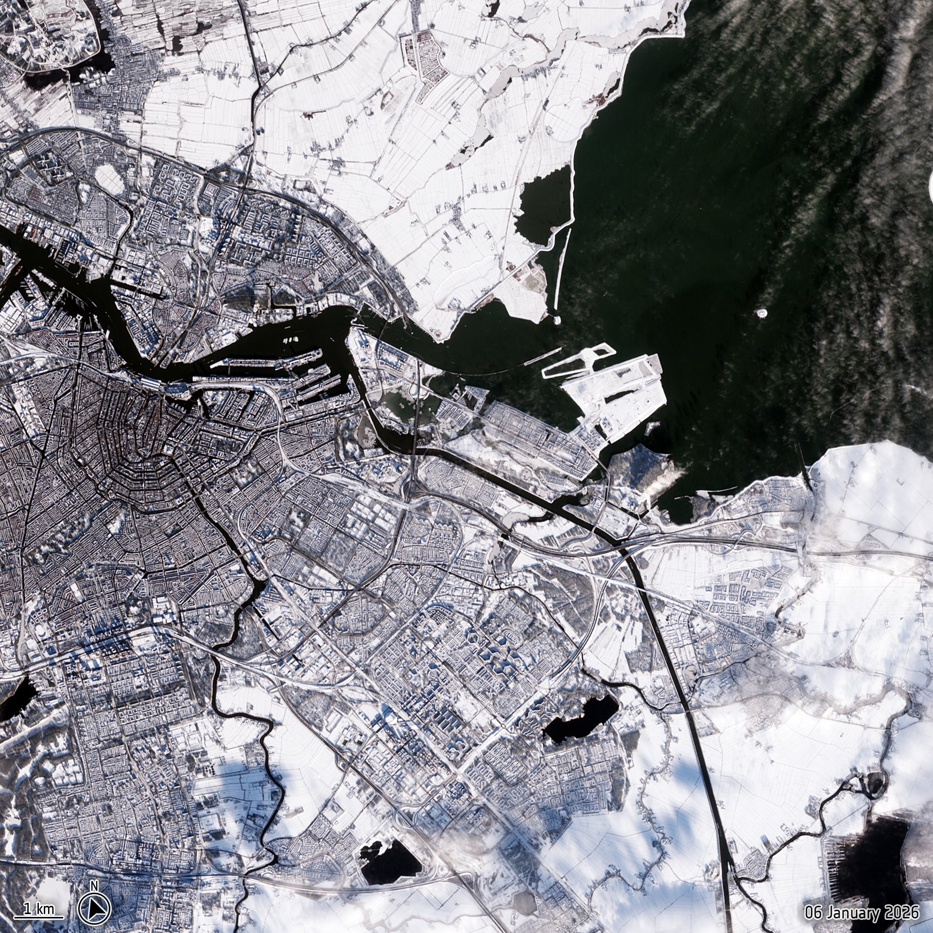
❄️ Nouvelles images satellites de l'Europe sous la neige : Bruxelles et Amsterdam, et l'Europe du Nord, le 6 janvier
📷 #Sentinel2 et Sentinel-3 #Copernicus

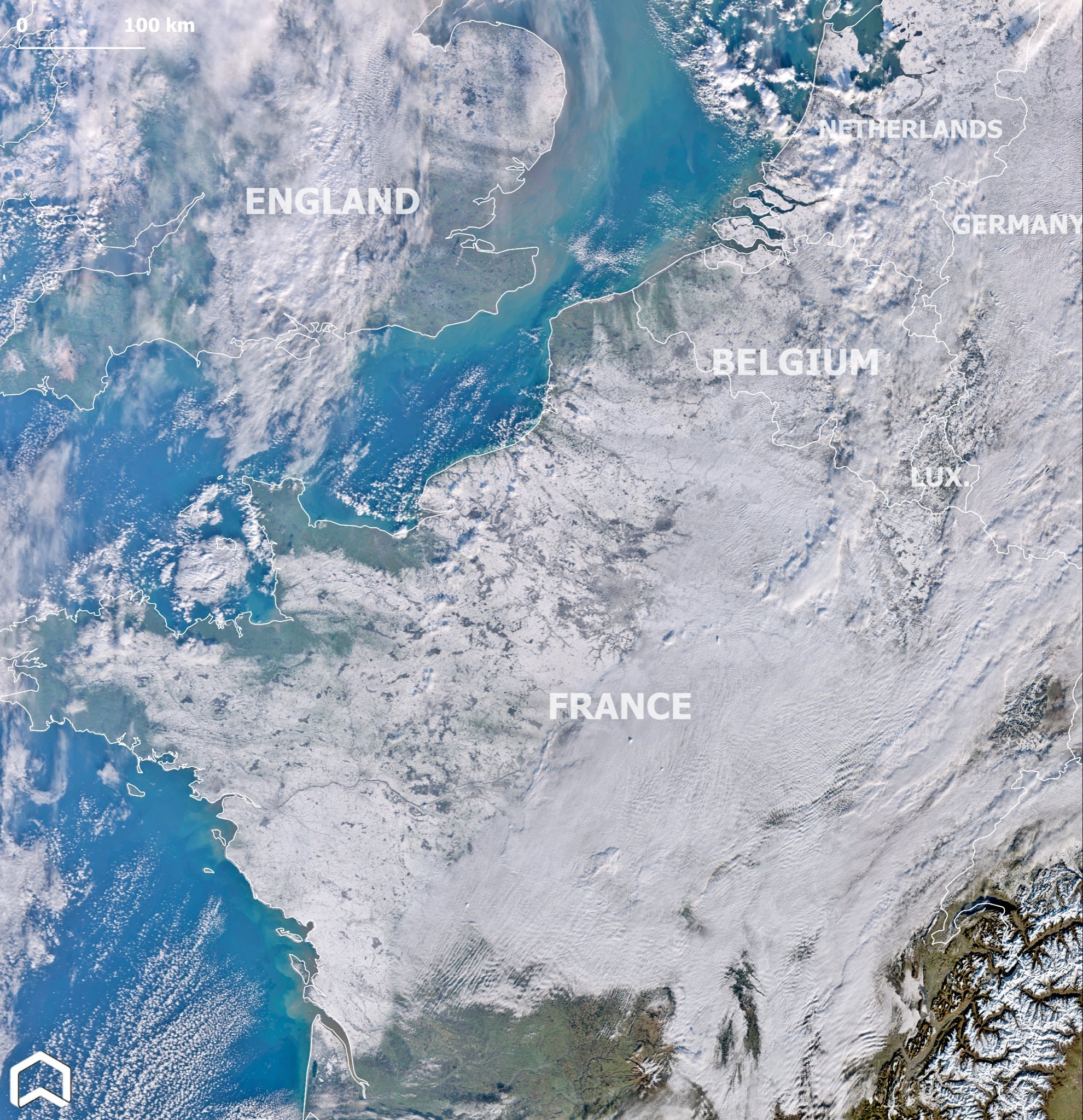
❄️ Il n'y a pas qu'en France qu'il a neigé. En Grèce aussi lors du réveillon du Nouvel An ou à Utrech aux Pays-Bas le 4 janvier, comme le montrent ces images prises par le satellite #Sentinel2 du programme européen #Copernicus


Mountain ecosystems of Greenland.
#EU #Copernicus #Sentinel2 #Greenland
https://www.copernicus.eu/en/media/image-day-gallery/mountain-ecosystems-greenland
Sal (salt) Island, Cabo Verde.
#EU #Copernicus #Sentinel2 #CapeVerde
https://www.copernicus.eu/en/media/image-day-gallery/sal-island-cape-verde
🌋 Impressionnante vue depuis l'espace par le satellite #Sentinel2 de l' #Etna enpleine éruption le 27 décembre.
via @tonyveco

The snow-covered Sharr Mountains on the borders of Kosovo, North Macedonia, and Albania rising above stratocumulus clouds seen by #Sentinel2 on 26 December
An Australian summer white Christmas! A blast from the south off the Southern Ocean brought summer snowfall to the mountains of #Tasmania. After the clouds cleared the settled snow was captured this morning by #Sentinel2 #whitechristmas

❓ Réponse de l'image spatiale mystère du jour : il s'agit du cratère Manicouagan au Canada par le satellite #Sentinel2 de #Copernicus.
Ce cratère d'astéroïde de 72 km de diamètre a été formé il y a 214 millions d'années ☄️
Pour en savoir + et zoomer : https://www.esa.int/ESA_Multimedia/Images/2025/12/Earth_from_Space_Manicouagan_crater


Photo has no secrets that #Sentinel2 cannot reveal.

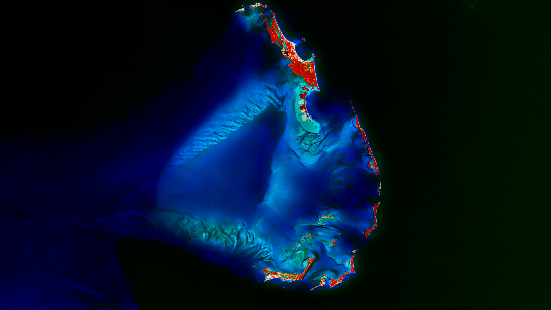
December’s Satellite Image of the Month features a stunning view of the Berry Islands (Bahamas). Learn more: https://www.mundialis.de/en/satellite-image-of-the-month-december-berry-islands-bahamas/
#OSGeo #OpenData #Sentinel2
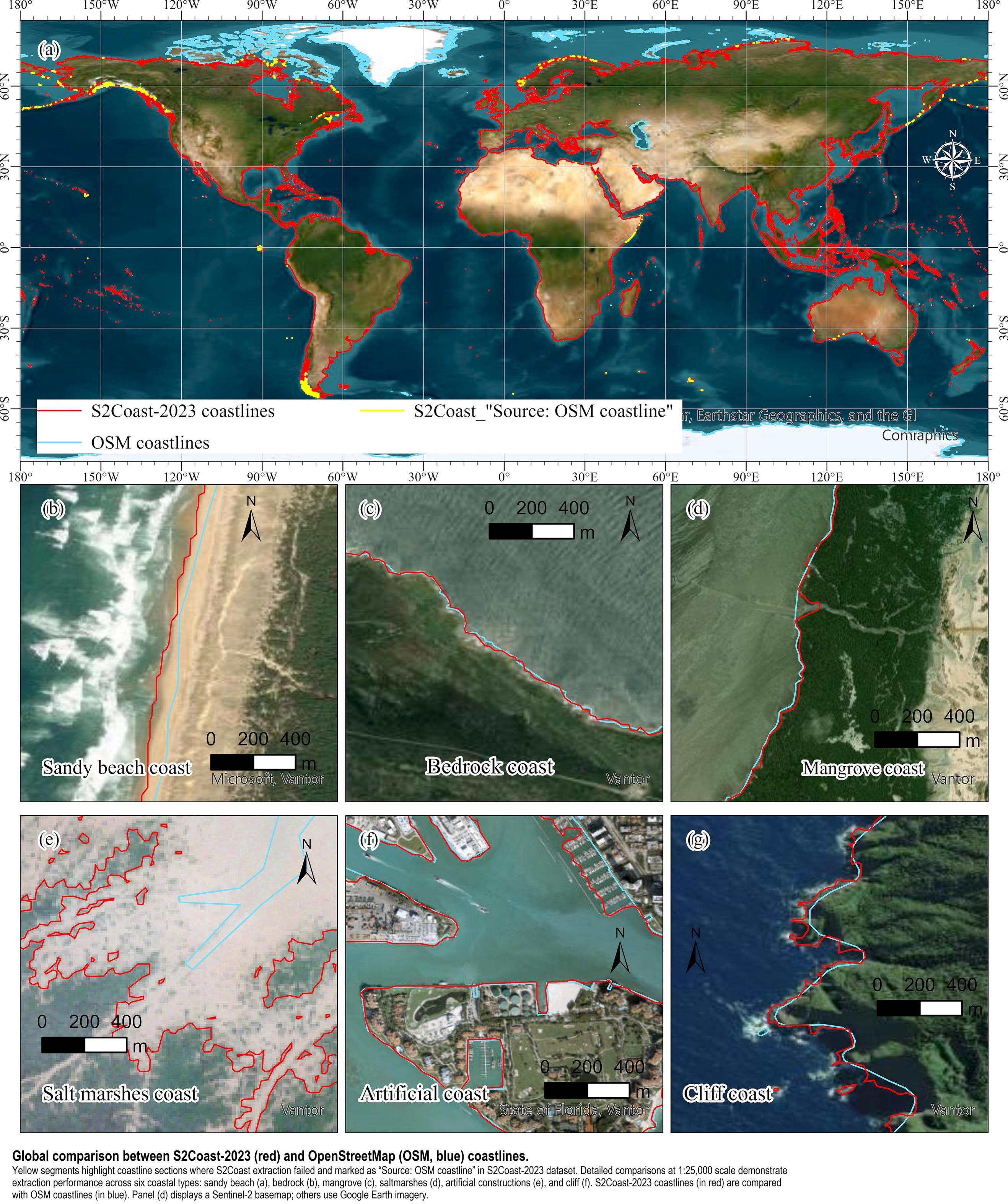
S2Coast-2023 - The First Global 10-Meter Resolution #Coastline Dataset Derived From Enhanced #Sentinel2 Composite #Imagery Using #GoogleEarthEngine
--
https://doi.org/10.1016/j.rse.2025.115186 <-- shared paper
--
https://zenodo.org/records/17092775 <-- shared data
--
“HIGHLIGHTS:
• Developed a GEE-based global coastline detection framework (S2Coast).
• HWLSentinel-2 serves as a unified and stable indicator for global coastline detection.
• The S2Coast-2023 coastline dataset is generated from annual Sentinel-2 imagery.
• Pixel-level accuracy compared with VHR-based OpenStreetMap coastlines..."
#GIS #spatial #mapping #RemoteSensing #CoastalResearch #ClimateChange #EarthObservation #Globalcoastlinemapping #Senitinel #googleearthengine #GEE #Compositing #coast #globe #global #model #modeling #detection #marine #terrestrial #ecosystems #knowledgebased #framework #spatialanalysis #spatiotemporal #QAQC


Nighttime lights from #Sentinel2

Sentinel 2 will be taking nighttime acquisitions TONIGHT, and the level 1B data will be available for TWO WEEKS ONLY following the acquisition: https://sentinels.copernicus.eu/web/sentinel/-/sentinel-2-nighttime-imaging-campaign
#RemoteSensing #NighttimeLights #NightLight #LightPollution #Sentinel2

Client Info
Server: https://mastodon.social
Version: 2025.07
Repository: https://github.com/cyevgeniy/lmst