Goodnight~
.
United Airlines Timetable 4/26/1981 - Seattle Night Space Needle
.
#UnitedAirlines #Seattle #SpaceNeedle #AirlineTimetable #Aviation #AviationHistory #AirlineHistory #Timetable #Seattleskyline #Avgeek
#SpaceNeedle


🌃✨ Seattle celebra a lo grande
El Space Needle se iluminó en honor al triunfo de los Seattle Seahawks en el Super Bowl LX. La emblemática torre se convirtió en símbolo de orgullo y unión para la ciudad, reflejando la emoción de los aficionados tras la conquista del trofeo Vince Lombardi.
#SuperBowlLX #SeattleSeahawks #SpaceNeedle #NFL #ABCDeportes
Sonic Bloom, Seattle, WA, USA [OC]
Sonic Bloom and Space Needle in Seattle on a sunny afternoon.
#photography #architecture #seattle #spaceneedle #travel #pixelfed #sightseeing #exploretheworld


SDOT will extend 4th Ave bike lane to Space Needle, Thomas Street this spring
From the SDOT project page.SDOT will begin work in the spring to complete the north end of the 4th Avenue protected bike lane, extending it from its terminus at Vine Street to Seattle Center and Thomas Street. The project is timed to be complete before the World Cup this summer (if it happens).
The design has evolved a bit since the earlier version we wrote about last August, though the diagonal crossing at 4th and Cedar remains and the design for Broad Street is not as ambitious as we had hoped. We spoke with members of the project team to learn the reasoning and restraints behind these compromises.
People will soon be able to bike the most direct route between downtown and the Space Needle entirely within a protected bike lane. People using the 4th Ave bike lanes today are unceremoniously spit out on to a wide, four-lane roadway with only sharrows painted on the ground. This is bad for all users, but it’s especially jarring for people unfamiliar with biking in the city who are just trying to get from the center of downtown to the city’s most iconic and visible landmark. The lane has ended abruptly at Vine since 2021 when the 4th Ave bike lane was finally constructed after years of delays.
The existing bike lane will extend one more block from Vine to Cedar. At Cedar, a new diagonal bike lane crossing will shift the two-way bikeway from the southwest side of 4th Ave where it is through downtown over to the northeast side. We were critical of this diagonal shift in our previous post, but the project team pointed to a few advantages they say make it work better.
One advantage is that most people driving on 4th Ave make a left turn onto Denny Way. There is also a double-lane left turn at that intersection and no crosswalk on the east side. Moving the bikeway so it can cross Denny on the east side will make this intersection much easier and give the bike lane a longer green light since it can be green during the left turn phase. No right turns will be allowed from 4th onto Denny.
One interesting consideration here, though, is that Mayor Katie Wilson has promised bus lanes on Denny Way where they are needed. So if the section of Denny between Broad and 4th got a westbound bus lane, then there would no longer need to be two left turn lanes from 4th to Denny, which would also make it much easier to add back that missing crosswalk and perhaps even move the bike lane to the west side of the street some day. Complete streets, when done right, can trigger a whole chain reaction of safety improvements like these. I hope the Denny Way team and the 4th Ave bikeway team are putting their heads together on how they can link up and support each other’s projects.
Another advantage of moving the bikeway to the east side of the street, however, is that north of Denny the bikeway would not cross in front of the 7-11 or parking lot driveways.
At Broad Street, the bikeway will split into two one-way bike lanes on either side of Broad. Most bike movements would happen during a new all-way walk and bike phase at this intersection in front of the Space Needle driveway.
Broad itself will be reconfigured to expand the amount of drop-off, charter bus, and bike and scooter parking. There will be one general traffic lane in each direction as well as some turn lanes, itself a big win since this street has maintained the design of a highway connector street, a role it has not played since 2014. However, we argued that the city should go even further by making the road one-way and dedicating about half of it to biking, Seattle Center access and maybe even some public art.
The problem is that it is currently designated as the hazardous freight route for trucks carrying cargo that is not allowed in the SR-99 tunnel, under the convention center downtown or on central downtown streets. Instead they must travel on the surface roadway along the waterfront, then travel up Broad to 5th, then to Mercer, then back to I-5. Very few trucks make this movement, but they do need an option. The city can change the hazardous cargo route, but that is likely a whole other project with its own challenges. Surely we can think of a better place than in front of our most popular tourist attraction, but hazardous cargo is also the kind of thing that nobody really wants near them. In the end, it was not something within the scope of this project.
The need to preserve the street for these trucks means that they could not use the monorail pillars to demarcate new car-free space along the edge of Seattle Center, as was Seattle Bike Blog’s suggestion. The team modeled it out and found that large trucks would have difficulty making the turn around the monorail pillar, and a hazmat truck collision with a monorail pillar would be a pretty bad thing to happen. Now, I’m sure it could be done if there were also design changes on 5th Ave N, but again that gets out of the scope of this project.
Finally, the project will add an all-crosswalk phase at the 5th/Broad/Thomas intersection, which will allow people on bikes to connect between the new lanes on Broad to the bikeway on Thomas Street.
The project makes a couple needed connections while leaving a couple big ones hanging. There will be no connection to the existing 5th Ave bikeway north of Memorial Stadium, and there will be no bike lanes on Broad Street between 4th Ave and the new waterfront bikeway. There is a block of protected bikeway on the north side of Broad between 1st and 2nd Avenues, but nothing between 1st and the waterfront or between 2nd and 4th. Completing the Broad Street bike connection was, you guessed it, outside the scope of this project.
Seattle bike network is coming together in patches. Sometimes we get big patches. This one is a small patch. It is frustrating to leave such large gaps open, but it is still a significant improvement over the current state.
#SEAbikes #Seattle


Morning #Seattle vibes, the #SpaceNeedle is reflecting through the fog like crazy


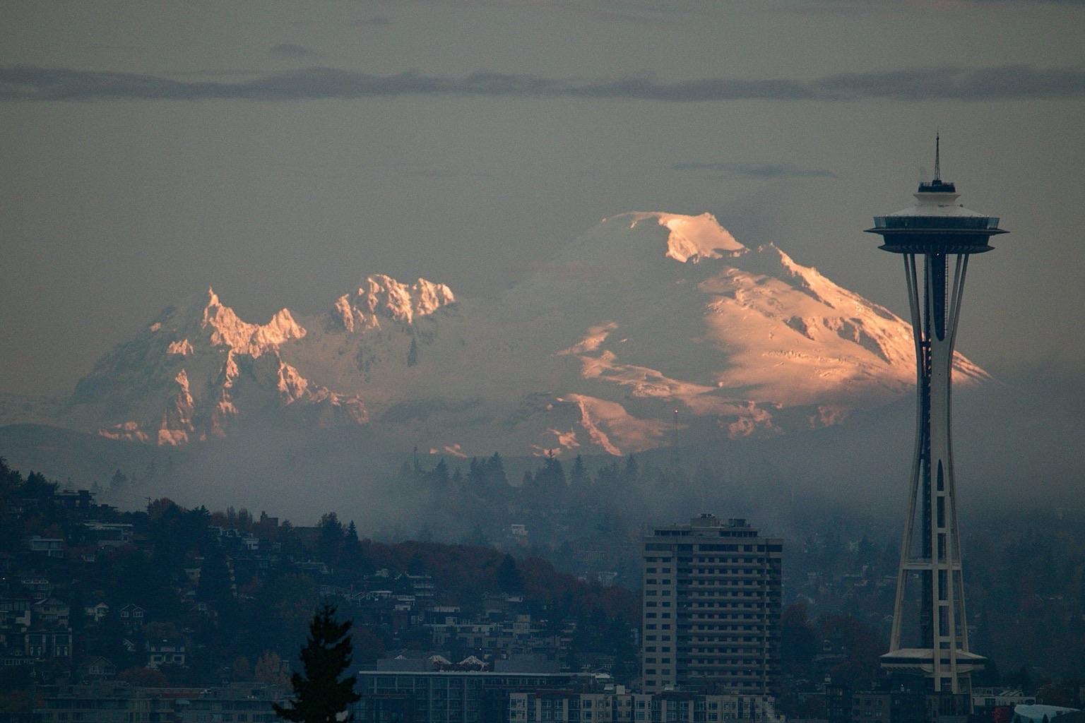
A very snowy Kulshan (Mt. Baker) and Seattle Space Needle last night as seen from West Seattle.
#Kulshan #MtBaker #SpaceNeedle #Seattle #WestSeattle #PNW #Photography


RE: https://clacks.link/@tithonium/115820925027578463
I was kind of wondering why KING5 didn't change over to the higher-altitude cams over the fog banks during last night's fireworks.
This is why. xD
It's 2026! We did it!
We survived the dumpster fire that was 2025!
Last night here in #Seattle we had fireworks at our tall friend the Space Needle. There was thick fog, a drone show was cancelled due to it and the broadcast of the show very much so fit 2025... it was a disaster.
You couldn't see much. It felt so fitting to end the year like this.
*My bad... apparently it's called 'Alaska Airlines New Year’s at the Needle' this year lol.


The #SpaceNeedle Panocam right now doesn't do it justice. It does look trippy though seeing the moisture in the air and the golden hue from the lights in the city.
Slept all afternoon and evening here, am still recovering from the move last week.
Awoke and went outside for a smoke with my coffee... it's very wet tonight here in #Seattle.
Even the #SpaceNeedle camera looks intense with all the moisture in the air right now.
It’s almost Thanksgiving. I’m thankful for Mudhoney and their record On Top! Recorded live up on top of the Space Needle in Seattle. I listened to this live on KEXP the day of.
Have a good Thanksgiving everyone.
.
#mudhoney #spaceneedle #vinylcommunity #recordcollecting #morningcommutemusic


"Cold Waters"
#Teableau 10Nov25
Not sure if it's evident here, but the etching on the cobalt blue mug is of the Space Needle. 💙
#Tea #PNW #Teableau #TeaCozy #TeaCosy #BlackTea #Handmade #Sewing #GlassArt #Ceramics #Figurines #Ocean #SeaLife #Dolphins #Octopus #SpaceNeedle #WesternWashington
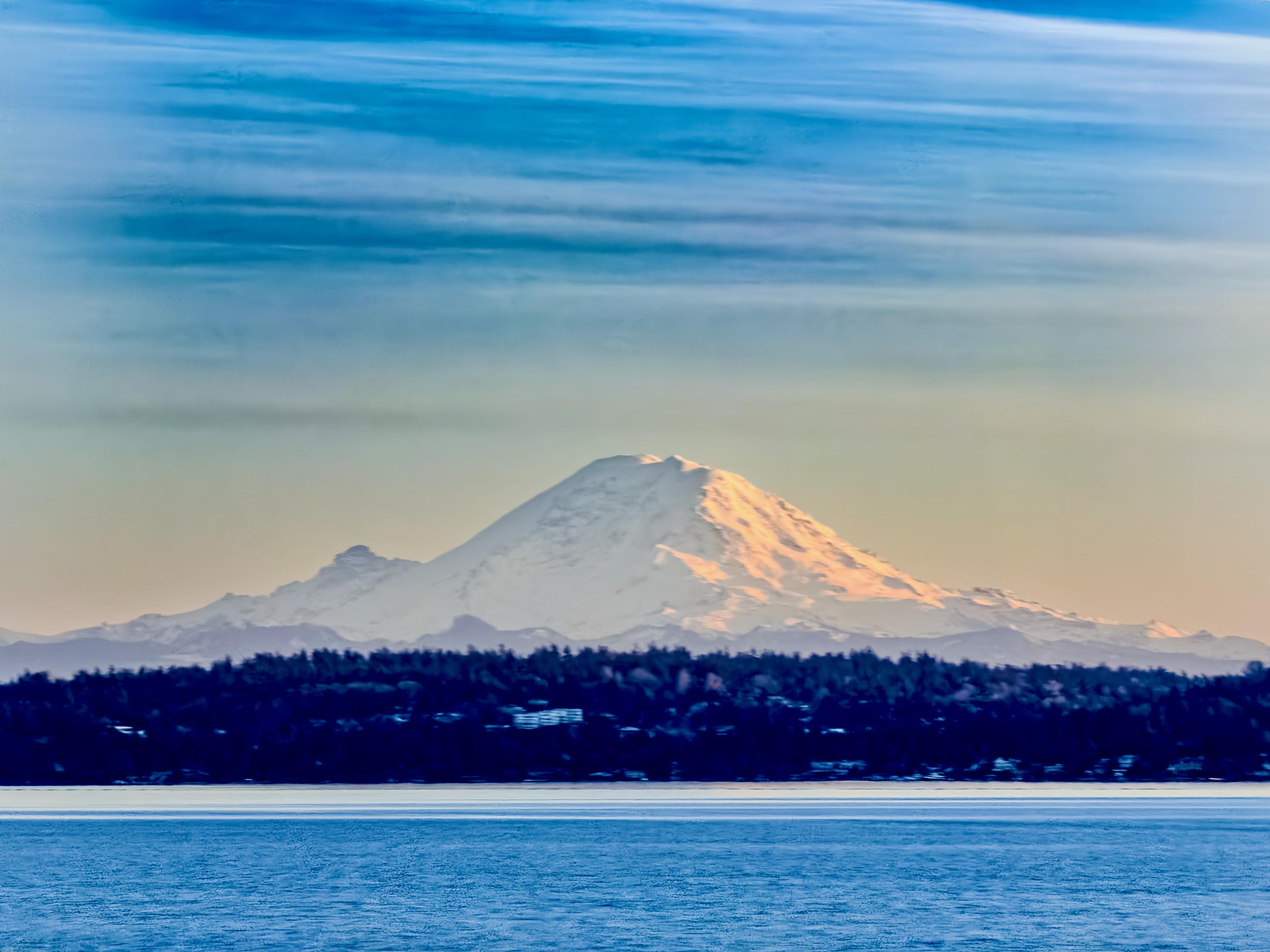
Kulshan (Mt. Baker) this morning from West Seattle.

Our shoutout for the top social post of the day on Seattle Space Needle goes to @falconsroaming on Instagram. From @falconsroaming: Captures the iconic Seattle landscape with the Space Needle and Mount Rainier at sunset, highlighting the city's beauty and renowned skyline views. #Seattle #SpaceNeedle #SunsetPhotography #trpdrm


Here’s one with a human and a tear
#WestSeattle #Seattle #Alki #SpaceNeedle
#photo #photography

Client Info
Server: https://mastodon.social
Version: 2025.07
Repository: https://github.com/cyevgeniy/lmst