
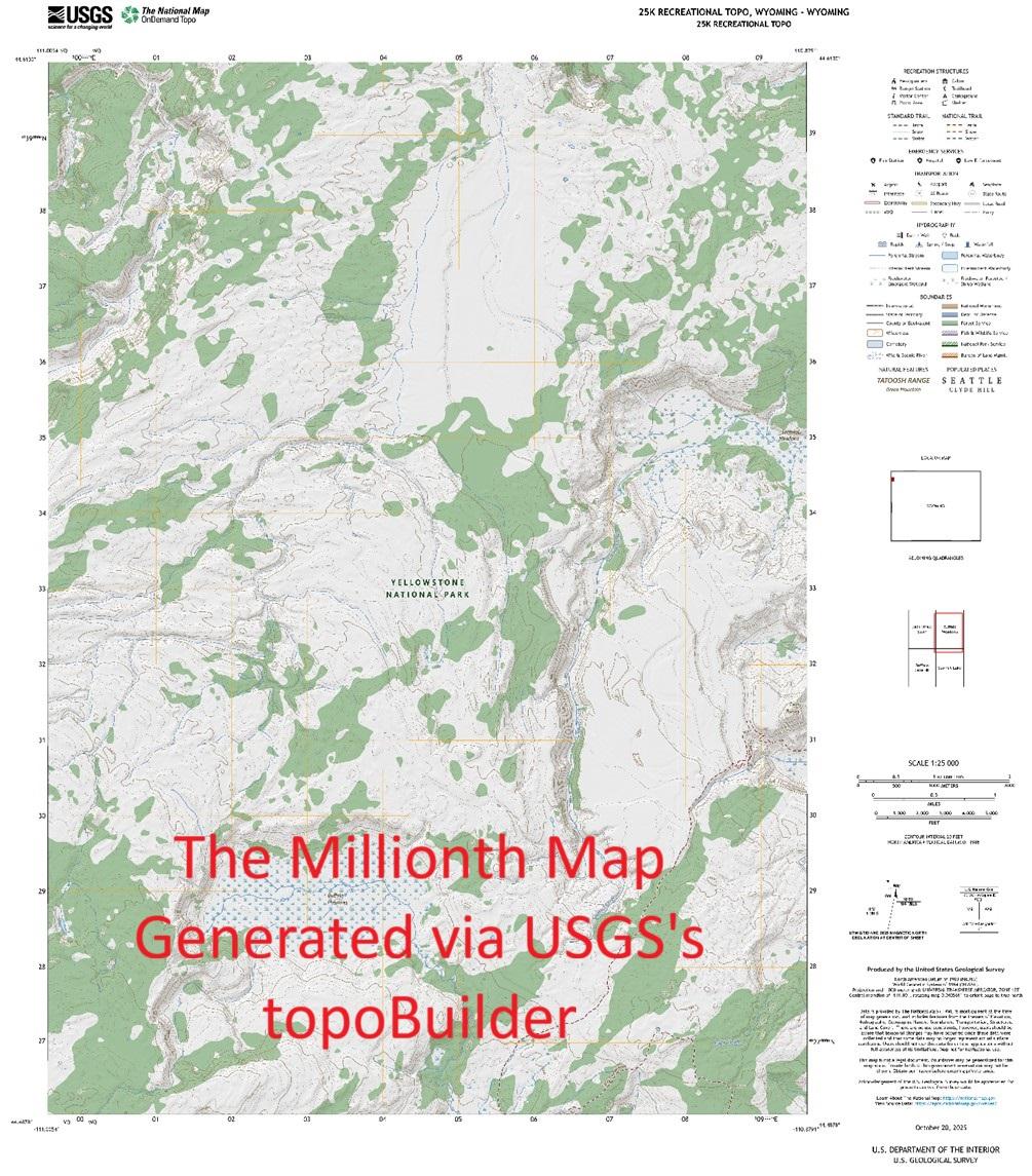
USGS topoBuilder Milestone of 1 Million Maps Delivered
--
https://www.usgs.gov/programs/national-geospatial-program/topobuilder <-- USGS topoBuilder Open Source / Open Data creation page, make your own custom USGS ‘topo map’!
--
“Each year, [the #USGS has] seen steady growth in map requests, underscoring the public’s trust and appreciation for these innovative products.
This [USGS topoBuilder Milestone of 1 Million Maps Delivered] is a testament to the dedication and expertise of colleagues across the National Geospatial Program and the National Geospatial Technical Operations Center. The success of topoBuilder is built on the collective efforts behind The National Map...
[The USGS] has modernized and advanced #topographic mapping…”
#GIS #spatial #mapping #NGP #NGTOC #usecase #fedscience #fedservive #topomap #ondemand #custom #USGS #topobuilder #opendata #publicservice #publicgood #milestone #TNM #NationalMap #free #recreation #usecase #agriculture #hiking
@USGS
#NGTOC


Streams & River Names Across The USA From USGS NHDPlus
--
https://www.linkedin.com/posts/john-hammond-9b4a932b_ever-wonder-how-streams-and-rivers-differ-activity-7395939476793090048-QvLc <-- shared technical post
--
H/T John Hammond | Research Hydrologist @ USGS
“Ever wonder how streams and rivers differ in naming across the country and what the most common names are?...
----
NAME COUNT
--
Mill Creek 6,213
Spring Creek 5,862
Dry Creek 5,750
Bear Creek 4,945
Beaver Creek 4,740
Rock Creek 4,514
Indian Creek 4,231
Cedar Creek 3,849
Willow Creek 3,777
Cottonwood Ck 3,694
Big Creek 3,424
Clear Creek 3,223
Sand Creek 2,863
Deer Creek 2,781
Turkey Creek 2,752
Wolf Creek 2,701
Mud Creek 2,518
Crooked Creek 2,176
Brush Creek 2,019
Buffalo Creek 2,009
Elk Creek 1,950
Salt Creek 1,932
Horse Creek 1,899
Silver Creek 1,887…”
#water #hydrology #name #USA #NHDPlus #variety #names #rivers #streams #NGTOC #3DHP #national #country #CONUS #nomenclature
#USGS


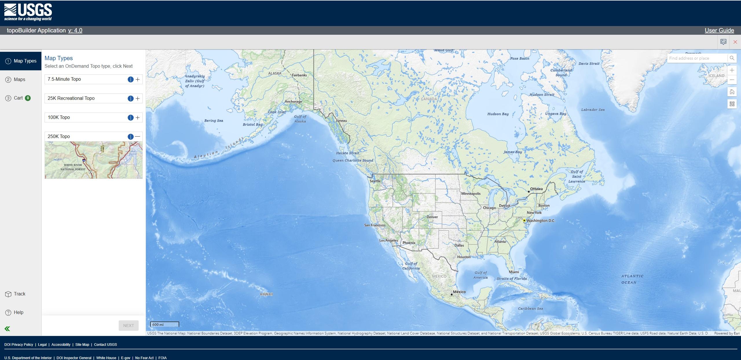
Latest #USGS Map-Product Release - 250K Topo OnDemand Topo Products Now Available Through The Topobuilder Application
--
https://www.usgs.gov/programs/national-geospatial-program/news/regional-view-reliable-data-introducing-usgs-250k-topo <-- USGS product announcement page and topoBuilder custom map construction application access
--
“The U.S. Geological Survey (USGS) has launched the 250K Topo, a new digital map product designed to support regional planning, land and resource management, and emergency response coordination…”
--
#GIS #spatial #mapping #USGS #OnDemandTopo #NGP #topoBuilder #OnDemand #250KTopo #Geospatial #TopographicMaps #GIS #MappingInnovation #OpenData #Maps #NGTOC #NGP #custom #opendata #latest #spatialdata #topomap #fedservice #fedscience #publicgood
@USGS


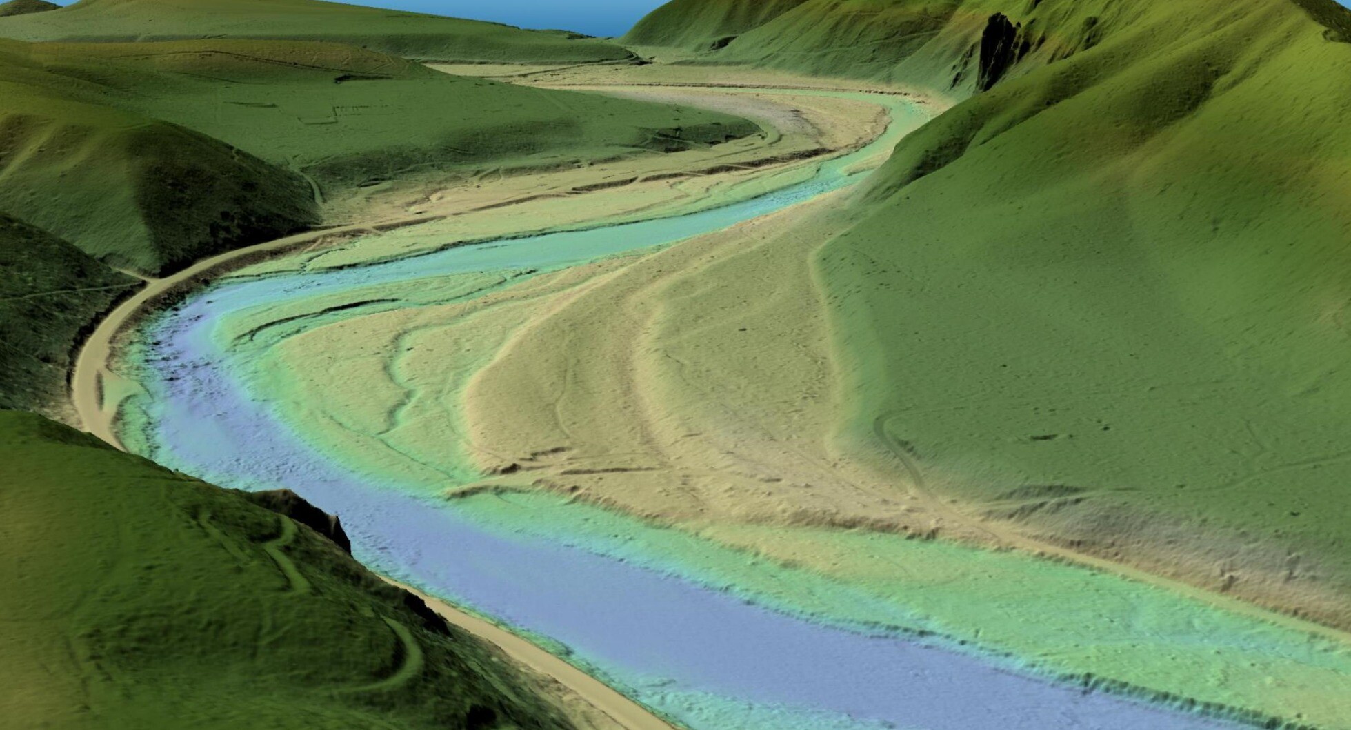
Collaboration Advances Elevation Mapping – USGS EROS And NGTOC Work Together To Map A 1 Metre Digital Elevation Model For A Watershed
--
https://www.usgs.gov/centers/eros/news/collaboration-advances-elevation-mapping <-- shared technical article
--
https://doi.org/10.5066/P1CEPE2M <-- USGS data release, Lower Androscoggin Watershed Hydrologic Unit 8 Seamless 1-m DEM Pilot, 2013 to 2020
--
#GIS #spatial #mapping #remotesensing #LiDAR #water #hydrology #3dep #3dhp #3dtnm #NGTOC #spatialanalysis #elevation #DEM #EROS #seamlessonemeter #Androscoggin #ME #maine #research #integration #watershed #opendata
@USGS | @USGS_EROS


Consolidated Standardized Survey-Grade Checkpoints 3DEP 2010 to 2017 [USGS]
--
https://www.sciencebase.gov/catalog/item/67075e6bd34e969edc59c3e7
--
“One of the key aspects of 3DEP data is that data is verified by a collection of certified survey-grade GNSS checkpoints spread throughout each project. These points have always been available but were difficult to find and not standardized. [The USGS] have collated and standardized almost 42,000 of these checkpoints and are making them available for other uses. These points here in this first phase span from 2010-2017, but [the USGS] are in the process of making these available for all [their] projects, and hope to enable them in different ways in the future...”
#GIS #spatial #mapping #USGS #USA #elevation #opendata #remotesensing #LiDAR #ifSAR #3dep #3dhp #water #hydrology #3d #opendata #3dtnm #checkpoint #checkpointdigital #GNS #GPS #NGD #DEM #survey #surveygrade #accuracy #precision #calibration #digital #NGTOC #NAD83
@USGS


New Study Seeks To Shed Light On Earthquake Hazards In The Gallatin Range
--
https://www.usgs.gov/observatories/yvo/news/new-study-seeks-shed-light-earthquake-hazards-gallatin-range <-- shared technical article
--
#GIS #spatial #mapping #remotesensing #LiDAR #earthquake #fault #scarps #faulting #opendata #3dep #NGTOC #ruptures #surfaceexpression #risk #hazard #geology #engineeringgeology #geomorphology #geomorphmetry #seismology #elevation #topography #EastGallatin #ReeseCreek #faultsystem #EGRCFS #GallatinRange #GardnersHole #Yellowstone #Wyoming #Montana #USA #glaciation #superposition #dating #geologichistory #NationalSeismicHazardModel #model #modeling #spatialanalysis #spatiotemporal #massmovement #hydrothermal #YellowstoneNationalPark
@USGS


CU Denver Career Fair Participation - With The USGS
--
https://architectureandplanning.ucdenver.edu/career-connections/employers <-- link to CU Denver employer connection job
--
Always a pleasure to be part of a career fair…
#GIS #spatial #mapping #careerfair #cudenver #usgs #careerdevelopment #NGTOC #NGP #jobfair #jobfair2024 #careerempowerment #Colorado #denver #federaljobs #federalservice
@USGS @CUDenver


Inflation Reduction Act Accelerates USGS Effort To Collect High-Resolution Data Of Landscapes Across 25 States [3DEP LiDAR and other elevation open datasets]
--
https://www.usgs.gov/news/national-news-release/inflation-reduction-act-accelerates-usgs-effort-collect-high-resolution <-- USGS news release
--
#GIS #spatial #mapping #NGTOC #3DEP #elevation #lidar #ifsar #opendata #ira #infrastructure #USGS #CONUS #Alaska #topography #pointcloud #dem #costbenefit #roi #benefits #naturalresources #3delevationprogram #funding #seamless #1metre #topobathy #CoNED #tbdem #hydrospatial #bathymetry #landscapes #landcover #hydrology #riverbeds #precisionagriculture #floodmapping #flooding #ecosystems #partnerships


Mapping The Land [USGS 3DEP program]
--
https://connectedworld.com/mapping-the-land/ <-- shared technical article
--
#GIS #spatial #mapping #LiDAR #opendata #3DEP #3DHP #elevation #remotesensing #TNM #QL1 #TheNationalMap #USA #NGTOC #3delevation #data #infrastructure #natural #constructed #engineering #publicsafety #planning #model #modeling #urbanplanning #agriculture #economicdevelopment #economicbenefits #coastal #risk #hazard #geology #engineeringgeology #massmovement #USGS
@USGS


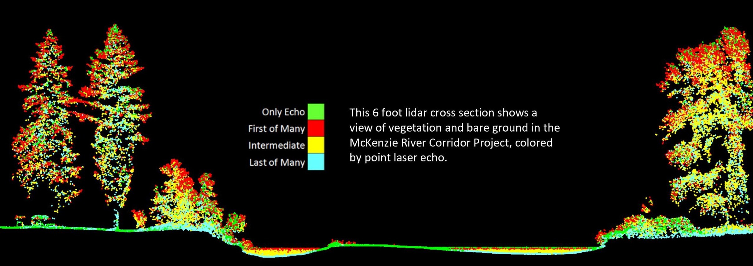
McKenzie River Topobathymetric Lidar Validation - USGS Field Survey Data
--
https://www.sciencebase.gov/catalog/item/62cc41bcd34eeb1417bb24fb <-- shared technical article
--
#GIS #spatial #mapping #remotesensing #hydrospatial #earthobservation #USA #opendata #Oregon #McKenzieRiver #3dep #elevation #LiDAR #topobathmetry #topobathy #USGS #GNSS #NGTOC #greenlightlidar #engineeringgeology #ecosystem #water #hydrology #fisheries #inland #geomorphology #geomorphometry #changedetection #geoscience #TLS #surveying
@USGS


Instructional Videos on Using [USGS’s] The National Map [Open Data] Products and Services [3DEP Elevation, Hydrology, etc]
--
https://www.usgs.gov/programs/national-geospatial-program/training <-- shared technical training resource
--
https://www.usgs.gov/programs/national-geospatial-program/national-map <-- background to the USGS’s Accessible National Map Open Data
--
#GIS #spatial #mapping #USGS #opendata #elevation #hydrography #hydrology #NGTOC #NGP #3DEP #3DHP #topoBuilder #USA #gischat #TNM #TheNationalMap #products #services #dataportal #tutorials #tutorial #trainingvideos #videos #learning #continuingeducation #education #educationandtraining #free #videolessons #videolearning #topographic #topographicmaps #instructional #onlineclasses #onlineeducation #onlinelearning
@usgs


The #USGS National Geospatial Technical Operations Center (#NGTOC) is seeking high school, associate, undergraduate, graduate level student (working towards a degree in Geography) to gain practical experience in using GIS, and analyzing scientific data. NGTOC Office of Operations creates, manages, and delivers #elevation and surface water mapping data in support of The National Map. Please see https://www.usajobs.gov/job/738912900 which closes on 8.9.23. #gischat #hydrology #STEM #mapping
The #USGS National Geospatial Technical Operations Center (#NGTOC) has several geographer openings for recent graduates (including those with an associates, vocational or technical degree or certificate from a qualifying educational institution). Duties include working as a member of a team to solve problems associated with assembling, creating, evaluating, and integrating new or existing spatial data. #NGTOC #gischat #lidar #hydrology See
https://www.usajobs.gov/job/738926700 which closes on 8.9.23.
Looking for a role whilst studying?
Several USGS NGTOC job openings for current students. Please share widely!
Denver, CO and Rolla, MO locations, possible opportunities for some telework...
--
https://lnkd.in/eERT4KUc <-- jobs' descriptions and announcement
--
https://lnkd.in/eWAZY4kj <-- details of USGS's NGTOC
--
#GIS #spatial #mapping #gischat #jobannouncement #openings #nowhiring #employmentopportunities #employmentopportunity #students #trainee #traineeship #trainees #USGS #NGTOC #geography #cartography #datascience #spatialanalysis #spatialdata
@usgs
The USGS Provides Maps & Imagery For Hurricane Response
--
https://www.usgs.gov/news/featured-story/usgs-provides-maps-and-imagery-hurricane-response <-- link to technical article
--
https://apps.nationalmap.gov/event-support-map-hub/ <-- Geospatial Information Response Team (GIRT) hazard USGS The National Map (TNM) page
--
H/T #XanFredricks
“🌊For this hurricane season, the [U.S. Geological Survey (USGS) Geospatial Information Response Team] GIRT has a newly designed, publicly available Event Support Map HUB site that offers access to applications, resources and information for hurricanes and other natural disasters…”
#GIS #spatial #mapping #USGS #NGP #GIRT #EROS #NGTOC #HDDS #3DEP #TheNationalMap #science #maps #imagery #hurricanes #tropicalstorms #hazards #emergencyresponse #disasterresponse #firstresponders #supportmaps #realtimedata #information #response #gischat #appliedscience
@usgs #USGS


National Hydrography Dataset (NHD) - USGS National Map Downloadable Data Collection
--
https://catalog.data.gov/dataset/national-hydrography-dataset-nhd-usgs-national-map-downloadable-data-collection <-- link to resource and data downloads
--
https://www.usgs.gov/core-science-systems/ngp/national-hydrography <-- link to open hydrology data, USA
--
#GIS #spatial #mapping #gischat #water #hydrology #USGS #NHD #NationalHydrographyDataset #publicdata #opendata #spatialdata #data #digital #network #TNM #NGTOC #NGP #geography #USA #CONUS #Alaska #Hawaii #cartography #appliedscience #spatialanalysis #watermanagement #waterresources #waterinfrastructure


Interdisciplinary Cartographer/Geographer/Computer Scientist
--
https://www.usajobs.gov/job/713059000 <-- direct link to the listing
--
Come work with me/us! 😊
#GIS #spatial #mapping #job #jobdescription #jobalert #USGS #NGTOC #research #opendata #researcher #federalgovernment #FederalService #USA #gischat #employment #employmentopportunity #employee #cartographer #geographer #computerscientist
[note that I can't supply any specific details beyond what is the listing]