#MMGIS

65dBnoise65dBnoise
2026-02-18

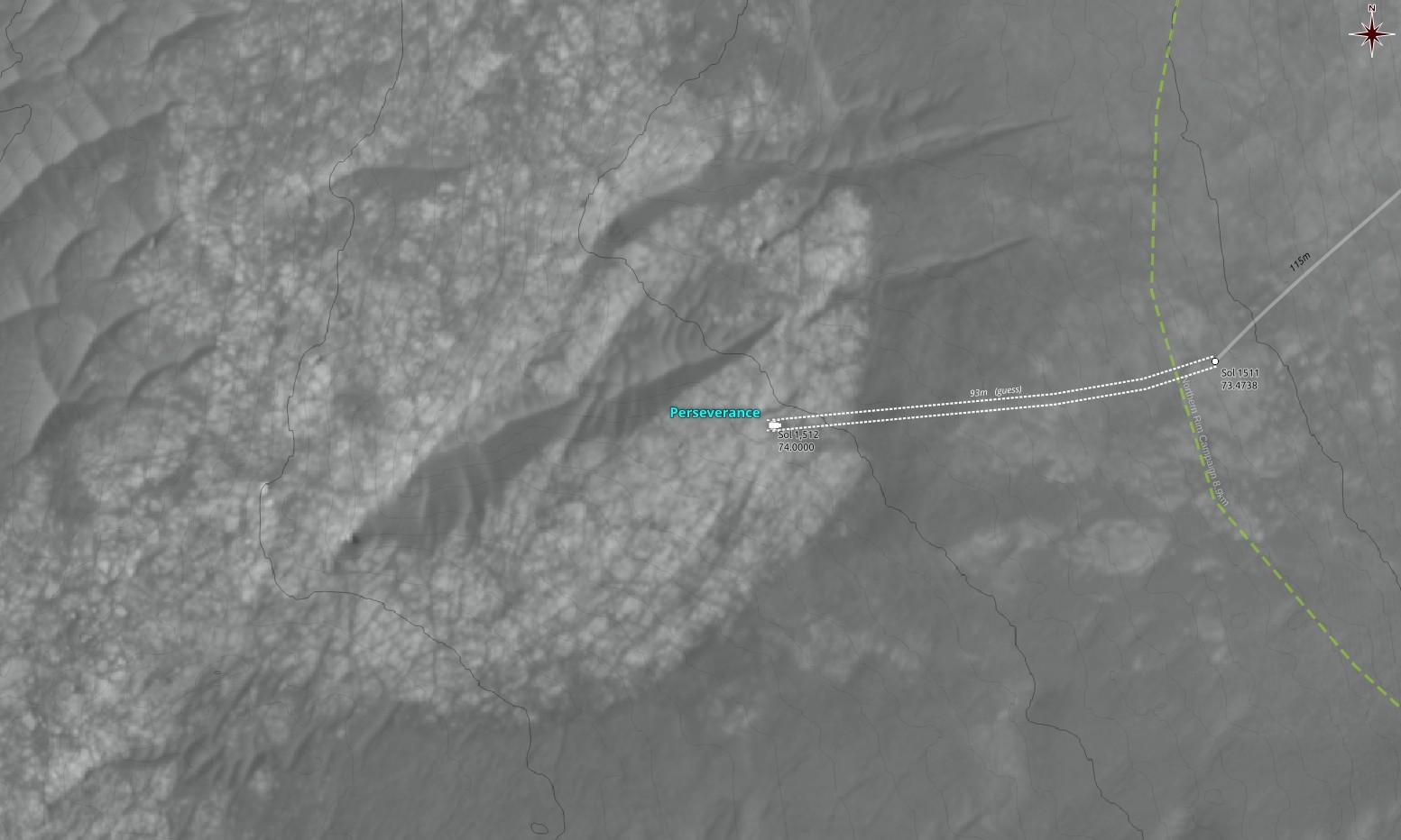
So, this may have something to do with the fact that we still haven't seen the official location of the rover at RMC 86.0000 after 2 days. 🤔

Worth mentioning that in my out-of-the-loop experience, the people are figuring the location out in no time, or, in about half an hour from the time they get into their office in the morning, once the relevant images have arrived.

But localization by humans isn't helping automate the rover's drives; does that, and we may see its influence soon

65dBnoise65dBnoise
2026-02-06

Talking about , and providing the right technical stuff without even a speckle of slop, here is what the MMGIS team has put in their map javascript, making sure eavesdropping technophiles (a.k.a. ) wouldn't miss it in a debugging console, if they opened one:

By the way, if you hate copying urls by hand, their Github page is github.com/NASA-AMMOS/MMGIS (copied/pasted, not typed 😆)

We love them because they love us.

65dBnoise65dBnoise
2026-02-06

So, has now come back closer to the planned route, after a short deviation to the west, and is about 140m away from Lac De Charmes. It should be there within one sol, if its present location proves to be not of much interest to the team.

Map drawn using , 's , and data

65dBnoise65dBnoise
2026-01-02

Back then, some of us were competing on who will figure out first where the had landed, by using the very first batch of images arriving from Mars to provide solid proof.

Here is one such proof of mine, superimposing one of 's landing images on an map based on images, for :

65dBnoise65dBnoise
2025-12-10

Apparently that low area passing through regolith mega-ripples wasn't interesting enough for , and it has now moved further SW to an area with about the same altitude. The altitudes shown on the map are relative to the landing location.

Processed, undistorted, leveled NAVCAM_LEFT mosaic
looking SSW (198°) from RMC 82.5380
Sol 1709, LMST: 15:15:29
One original: mars.nasa.gov/mars2020-raw-ima

Credit: /JPL-Caltech/65dBnoise

65dBnoise65dBnoise
2025-12-08

As anticipated, has now reached the center of the area of lowest elevation along its route to Lac De Charmes, and has placed a nice flat piece of bedrock at (robotic) arm's length (but not inside its workspace).

Processed, undistorted, leveled, cropped NAVCAM_LEFT mosaic
looking NNW (342°) from RMC 82.3986
Sol 1707, LMST: 13:55:33
Original: mars.nasa.gov/mars2020-raw-ima

Credit: /JPL-Caltech/65dBnoise

65dBnoise65dBnoise
2025-12-05

either drove into a dead end and is now surrounded by heaps of sand, or found something interesting there, which we don't see yet…

Over-processed to show sand patterns, undistorted, leveled, cropped NAVCAM_RIGHT
looking ENE (71°) from RMC 82.2866
Sol 1704, LMST: 12:36:19

Original: mars.nasa.gov/mars2020-raw-ima

Credit: /JPL-Caltech/65dBnoise

65dBnoise65dBnoise
2025-12-02

Two more drives and will reach the lowest point of this area, where satellite imagery shows exposed bedrock thinly covered by regolith ripples (cyan ellipse).

If the geology proves interesting (IANAG), it is possible that the rover will spend the upcoming solar conjunction hiatus there (Jan 9, ± 1 week).

Map drawn in @QGIS using imagery from and and data from 's

65dBnoise65dBnoise
2025-12-02

New sol, new location for , RMC 82.1486, and a view of a megaripple about 60m away.

Processed, undistorted, cropped, leveled NAVCAM_RIGHT mosaic
looking NNW (342°) from RMC 82.1486
Sol 1701, LMST: 14:01:33

One original: mars.nasa.gov/mars2020-raw-ima

Credit: /JPL-Caltech/65dBnoise

65dBnoise65dBnoise
2025-11-29

m̶a̶y̶ ̶h̶a̶v̶e̶ ̶s̶e̶t̶ ̶a̶ ̶n̶e̶w̶ ̶r̶e̶c̶o̶r̶d̶

EDIT: Nope, mea culpa. I based my calculation on the wrong origin. The new location is about 130m along the planned route.

Processed, undistorted, leveled, cropped NAVCAM_LEFT
looking NE (53°) from RMC 81.4488
Sol 1698, LMST: 14:49:44

Original: mars.nasa.gov/mars2020-raw-ima

Credit: /JPL-Caltech/65dBnoise

Processed, undistorted, leveled, cropped NAVCAM_LEFT
looking NE (53°) from RMC 81.4488
Sol 1698, LMST: 14:49:44
65dBnoise65dBnoise
2025-11-22

There.

Processed, undistorted, cropped NAVCAM_LEFT
looking SE (125°) from RMC 81.3608
Sol 1690, LMST: 13:25:16

Original: mars.nasa.gov/mars2020-raw-ima

Credit: /JPL-Caltech/65dBnoise

65dBnoise65dBnoise
2025-11-18

@PaulHammond51
Apparently has moved again, and it's now at RMC 81.1418:

(the path is a guess)

2025-07-20

OP Lunch Talk #70: "MMGIS in Geospatial Mission Operations"

solarsystem.video/w/ibu9tdNmSF

65dBnoise65dBnoise
2025-11-07

A paved terrace

New location for , after two intermediate stops, probably to find the right place with the right rocks.

The second image shows the planed route to the south passing through some interesting terrain (see map)

Processed, undistorted NAVCAM_RIGHT, LEFT
RMC 80.2790 Sol 1675, LMST: 14:31:05
RMC 80.2956 Sol 1676, LMST: 11:23:44

Originals:
mars.nasa.gov/mars2020-raw-ima

Credit: /JPL-Caltech/65dBnoise

65dBnoise65dBnoise
2025-09-18

New location for , to another outcrop nearby. The new path is a guess.

Using

65dBnoise65dBnoise
2025-09-12

New location for , a few meters to NW from its previous one: RMC 79.0328, Sol 1622

Map made using with data from 's and

65dBnoise65dBnoise
2025-08-12

Apparently, after trying unsuccessfully twice to reach an outcrop 15 m higher, has called it quits and returned to its planned route to the south.

Its next stop may be some outcrops at 350m and 400m SE from its present location, a distance the rover can cover in just one or two sols, if it doesn't get distracted by something interesting in between.

The maps were drawn using with imagery and DTMs from and and data from

Heights are relative starting at Perseverance's Octavia E. Buttler landing location.
65dBnoise65dBnoise
2025-05-27

@JV_Honza

Apparently 's is now using the new maps & data created by the which includes areas west of Jezero. The animation below shows the difference (~3m):

mastodon.social/@65dBnoise/114

65dBnoise65dBnoise
2025-05-27

's has moved (probably some time ago) to a new dataset prepared by the which includes areas west of Jezero Crater, which may be where the Mars Sample Return mission (#MSR) could land, if the mission ever takes off.

For those interested in Martian maps and , here is where to find the new data:

Description PDF:
hou.usra.edu/meetings/lpsc2025
Source (5.1GB, includes raster and DTM):
asc-pds-services.s3.us-west-2.

##Mars2020

65dBnoise65dBnoise
2025-05-22

appears to be ready for some close examination of the bedrock at its new location at RMC 74.0000.

As with every change of site number, i.e. when drive numbers are reset to 0000 and the x, y, z data zeroed, localizing the rover is more difficult. Here I've done it by manual triangulation, using NAVCAM_RIGHT images whose center lines are seen on the map.

Used to draw the map, with data from 's , and

Client Info

Server: https://mastodon.social
Version: 2025.07
Repository: https://github.com/cyevgeniy/lmst