Punjab’s new plan aims to end child labor
https://fed.brid.gy/r/https://dailytimes.com.pk/1412535/punjabs-new-plan-aims-to-end-child-labor/

Punjab’s new plan aims to end child labor
https://fed.brid.gy/r/https://dailytimes.com.pk/1412535/punjabs-new-plan-aims-to-end-child-labor/

After 12 yrs I might be losing my enthusiasm for graphic design as a career. It’s undervalued and under appreciated as a skill and salaries stagnating for the few jobs that remain.
Thinking about pivoting to something like #UXdesign #uidesign #interactiondesign or #learningdesign and I’m also curious about #GISmapping but unsure where to start. I think ideally I need professional career guidance (if it exists for adults?)
Pls shout if you have any career change tips!
#GoogleEarth Alternatives — #Satellite & #GISMapping
1. #NASA #WorldWind – An open-source 3D virtual globe with satellite imagery and #geographic data.
2. #Cesium – A WebGL-based 3D globe used for high-end geographic visualization.
3. #MarbleKDE (Marble by KDE) – A lightweight, #OpenSource alternative with offline #maps.
[see more options in reply]
Discovering https://www.godawnpatrol.com/app made me excited for touring this winter in the Lake Tahoe basin.
Dawn Patrol is a backcountry skiing app designed to help you plan safer and smarter tours. It provides detailed route descriptions, advanced terrain analysis, and tools to assess avalanche risks, enabling skiers and snowboarders to make more informed decisions in avalanche terrain.
It pairs well with https://caltopo.com/'s live satellite overlays.
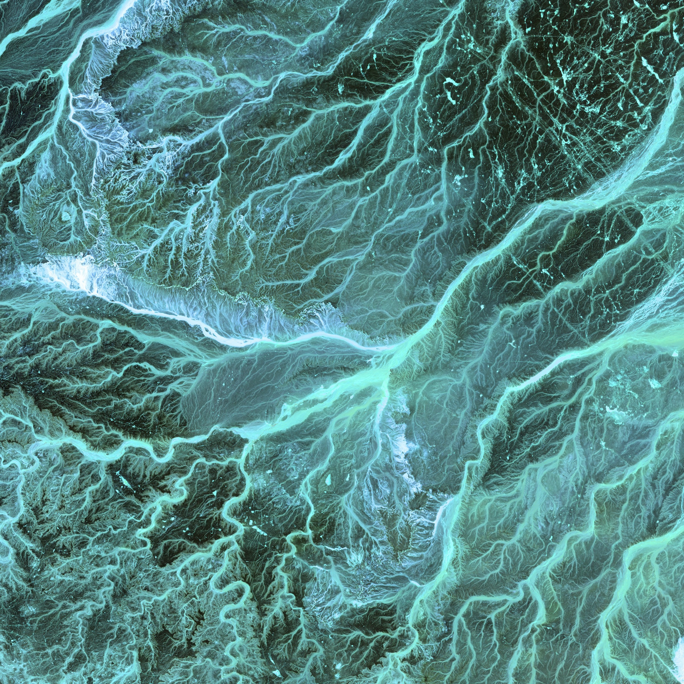
Using #qgis temporal controller to produce a #map to identify water surfaces in a #peatland landscape with #sentinel1 #sar backscatter .
Map covers the period before #moor fires in 2018 on Winter Hill #Lancashire (red dashed line) up to this winter, after #restoration work was undertaken.
If anyone can help point me to peatland habitat close to Winter Hill please contact me. Reference data still needed to refine the method.
#gis #gismapping #giscommunity #remotesensing
Schon angemeldet? Modul 2 "Open Source GIS" unserer Weiterbildung "GIS und Webmapping" startet am 27. März. Es gibt noch freie Plätze!
Meldet Euch direkt über unsere Webseite an -> https://gis-trainer.com/de/modul_opensource.php <-
Für Infos zu diesem Kurs oder zu unseren Weiterbildungen meldet Euch gern auch per Telefon oder E-Mail:
📞 030 / 820 70 659
📧 info@gis-trainer.de
#webmapping #opensourcesoftware #qgis #weiterbildung #gismapping #mapping
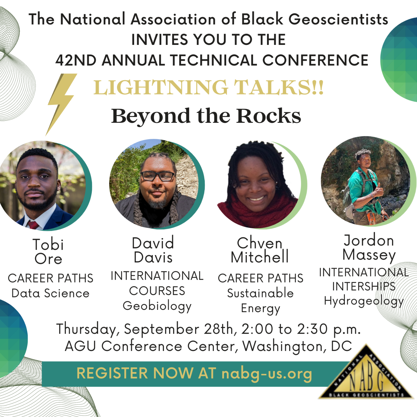
We are looking forward to this panel discussion in a few weeks! Today is the last chance to join us in Washington, D.C. for the 42nd Annual Technical Conference. Registration closes today. https://lnkd.in/eDgsVCXM <-- Link to registration page
Please share with any aspiring geoscientist or ally.
#NABG42 #NABG23 #NABGUS #beyondtherocks #geology #blackinstem #hydrogeology #geophysics #gismapping #geobiology #datascience #blackingeology
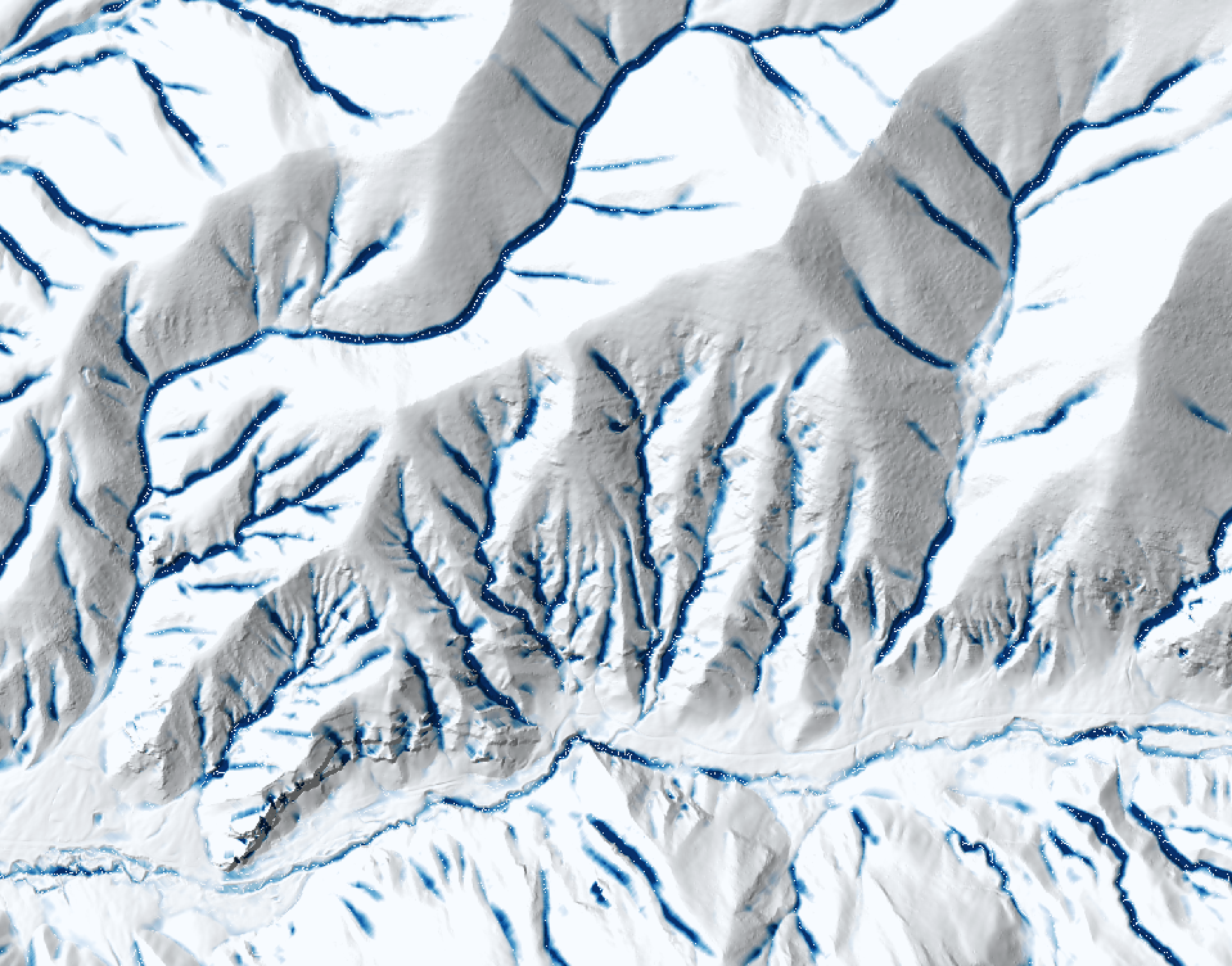
The impoundment size index (ISI) in #WhiteboxTools is great! In the image, sites that are non-impoundable by a 25-m dam are white and the darker blue a pixel is, the larger the upslope impoundment is. ISI could be used for siting #wetland construction projects, #riverrestoration, #flood modelling, #gully mapping, hydroelectric dam siting, and many other applications. #hydrology #spatialhydrology #topography #gis #gismapping #spatialanalysis #lidar
4 [Of Many] Careers In GIS [ / Spatial Data] With Great Job Outlooks
--
https://gis.usc.edu/blog/the-4-fastest-growing-career-fields-in-gis/ <-- shared article
--
[I am not associated with this university in any way, just thought that it was an informative article]
[My personal take is that unless you want specifically to be ‘Spatial Super Hero’ then pick a professional field that you appreciate & interests you - and then use GIS / spatial data skills to support that with your gained knowledge. Note that this field will almost certainly change over your career and that is A-OK; I started out as an engineering geologist, still keep my license current, then environmental scientist including nuclear site cleanups, and now work in the area of spatial data for hydrology, next is…]
#GIS #spatial #mapping #gischat #gismapping #career #careeradvice #careeradvancement #careeracceleration #job #jobtraining #training #traininganddevelopment #spatialdata #spatialanalysis #geography #cartographer #surveyor #urbanplanning #alldataisspatial