
R Coding for Ecology chapter on cblindplotR 🎨
Shows how to create colourblind-friendly maps and visualizations in R.
#rspatial


Are you interested in modern spatial data analysis and mapping? If you are looking for a way to improve your point-and-click workflow, R programming language is the perfect solution! With these powerful spatial packages, it is possible to handle the entire process in a transparent, reproducible and scalable way.

🗺️ fastfocal: fast moving-window and point extraction for rasters in R, optimized for large windows and common focal stats via FFT. Built on terra.


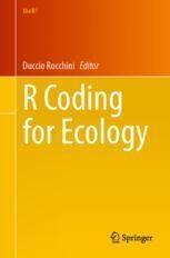
New R Coding for Ecology chapter on measuring landscape patterns with landscapemetrics and motif 📊🌍
https://doi.org/10.1007/978-3-031-99665-8_10
Preprint: https://doi.org/10.48550/arXiv.2405.06559
Code: https://github.com/Nowosad/landscapemetrics_motif_2026


"Géomatique et cartographie avec R" has been updated! :rstats: 🗺️ :osm:
- Données vectorielles avec {sf}
(vector data processing)
- Données raster avec {terra}
(raster data processing)
- Cartographie avec {mapsf}
(thematic mapping)
- OpenstreetMap
This manual is in French. A lighter, slightly outdated English version is available here: https://rcarto.github.io/cartography_with_r/


It's time for #TidyTuesday and we're looking at data on languages spoken in Africa! 🌍
Here's a small multiple map with countries where each language is spoken highlighted 📊 (top 10 most widely spoken only)
Code: https://github.com/nrennie/tidytuesday/tree/main/2026/2026-01-13


📢{duckspatial} v0.9.0 is now on CRAN !! 🚀 If you work with big spatial data in #rstats, duckspatial brings the power of @duckdb.org@bsky.brid.gy to spatial analysis in R. It is dozenz - 📦website cidree.github.io/duckspatial/ - Blog post: adrian-cidre.com/posts/014_du... #duckspatial #rspatial #duckdb

We just published a JOSIS paper on what spatial data science languages have in common and what they still need. Insights from across the R, Python & Julia ecosystems.
URL: https://doi.org/10.5311/JOSIS.2025.31.462
#SpatialDataScience #GISchat #OpenSource #RSpatial #GeoPython #JuliaGeo


#rstats {duckspatial} 0.9 is on CRAN, makes @duckdb 🦆 #spatial 🌍 more user-friendly, enabling faster big data spatial ops in R. Adrián Cidree shared a great breakdown of how we (+ @UrbanDemog ) are doing it:
📖: https://cidree.github.io/duckspatial/articles/duckspatial.html
💻: https://github.com/Cidree/duckspatial
#rspatial
🗺️ In his blog post, David O’Sullivan outlines an approach for dividing New Zealand into four regions with identical population counts.
URL: https://dosull.github.io/posts/2025-06-13-population-quadrants/


Introducing gdalcli by Andrew Brown -- an R frontend to GDAL’s unified CLI (≥3.11) 🌐
Compose and execute GDAL workflows with pipe-friendly functions.
Learn more: https://github.com/brownag/gdalcli

After I got my PhD and decided that the research/academia ladder was not my cup of tea, I moved to Barcelona to work as research technician, building databases and R code/packages for them. After 9 years, I'm still here, now as Data Scientist, still managing
databases and pipelines, webs, shiny applications and R packages.
3/3

Shortly after that, I moved to Asturias, close to the Cantabric Sea, where I spend 8 years getting my PhD on Plant Physiology (someday I will be able to talk about PhD students exploitation in the Spanish educative system, even if things are slighty better now).
Here is where my love for linux, open source and R began (goodbye SPSS and Windows, never looked back).
2/n

Inspired by @kamapu map for day 16 of #30DayMapChallenge and playing with the amazing {isocubes} by @coolbutuseless I decided to do an spatial introduction.
I'm from León, a province in the NW of Spain. Here is where I was born and raised and where after some time I got my BSc in Biology.
1/n


Some lecture notes on spatial and temporal modelling, illustrated using R - https://darrenjw.github.io/spatio-temporal/ - #rstats #rspatial #quarto

Some lecture notes on spatial and temporal modelling, illustrated using R - darrenjw.github.io/spatio-tempo... - #rstats #rspatial #quarto
Spatial and temporal statistic...
R package gdalraster was updated on CRAN a few days ago and binaries for Windows and macOS are now available. v.2.4.0 is a small feature release since we needed to update URLs for the repo and website. It does add several new wrappers for the GDAL spatial reference API, and a few other enhancements. A full changelog with the new URL is at:
The spcosa package provides an R framework for spatial coverage sampling.
Explore examples at https://git.wur.nl/Walvo001/spcosa


Client Info
Server: https://mastodon.social
Version: 2025.07
Repository: https://github.com/cyevgeniy/lmst