
I Am Proud To Be Part Of The Integrated Team Generating and Publishing An Open Data 3DHP Hydrology Spatial Data Product For The Nation At The USGS
--
https://doi.org/10.5066/P148NT7B <-- shared product DOI
--
https://commons.datacite.org/doi.org?query=10.5066%2FP148NT7B <-- shared DateCite repository record
--
https://3dhp.nationalmap.gov/ <-- 3DHP data is also available via a USGS spatial data service (with select & export capability)
--
[‘my’ first product DOI generation & publication as well ~smile~]
#GIS #spatial #mapping #data #water #hydrology #LiDAR #EDH #elevationderivedhydrography #3DHP #opendata #publicdata #DOI #stagedproducts #3DTNM #3DEP #NHD #national #USA #nonproprietary #waterresources #spatialanalysis #model #modeling #3d #vector #schema #DOI#geopackage #filegeodatabase #metadata #XML
@USGS
#elevationderivedhydrography


Elevation-Derived Hydrography [EDH] - The USGS’s Rich New Hydrological Features Dataset
--
https://doi.org/10.2489/jswc.2024.0314A <-- shared paper
--
https://pubs.usgs.gov/publication/tm11B12 <-- USGS EDH Representation, Extraction, Attribution, and Delineation Rules reference publication
--
https://www.usgs.gov/3d-hydrography-program <-- shared link to the USGS 3DHP page
--
[in my role, I have the pleasure of working with the valuable EDH process(es) and the data it produces on a daily basis]
#GIS #spatial #mapping #water #hydrology #hydrography #3dep #edh #3dhp #elevationderivedhydrography #opendata #elevation #dem #dtm #interpretation #waterfeatures #usecase #waterresources #floodmodeling #alignment #model #modeling #dataset #naturalresources #costs #benefits #economics #businessuse #publicdata #spatialanalysis #USA #USGS
@USGS


The 3D National Topography Model Call For Action—Part 1. The 3D Hydrography Program [USGS publication]
--
https://doi.org/10.3133/cir1519 <-- shared USGS Circular 1519
--
https://www.usgs.gov/3DHP <-- 3DHP home page at the USGS
--
https://hydro.nationalmap.gov/arcgis/rest/services/3DHP_all/MapServer <-- open data WMS for 3DHP, WFS to follow soon
--
[awareness: this is my primary project at the USGS]
#GIS #spatial #mapping #water #hydrology #USGS #3dhp #EDH #elevationderivedhydrography #3DHydrographyProgram #NHD #WBD #NHDPlusHR #nation #USA #nationwide #usecase #appliedscience #economicbenefits #planning #monitoring #decisionmaking #informeddecisions #3d #xyz #waterbody #stream #river #flowline #lake #network #routing #opendata #3dtnm #topography #internetofwater #infostructure
@USGS


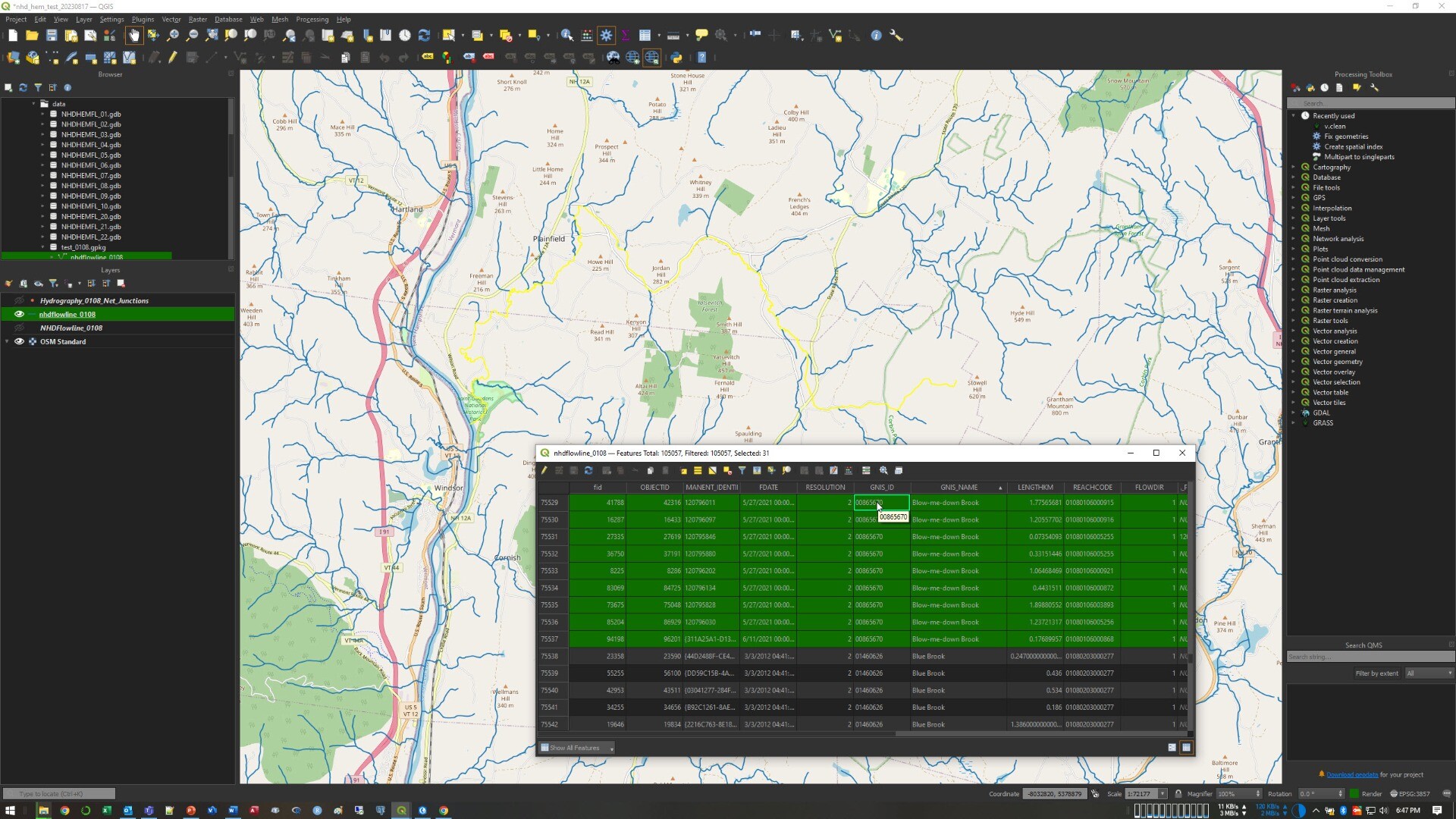
Blow-Me-Down Brook, NH – An NHD Flowline Picked ‘Randomly’
--
http://npshistory.com/brochures/saga/blow-me-down-na-1981.pdf <-- 1981 NPS guide
--
https://www.usgs.gov/3d-hydrography-program <-- USGS’s 3DHP home page
--
I am working on some hydroaddressing / network traversing technical approaches for 3DHP – and needed an example of a multisegment flowline in NHD-sourced dataset, and so ‘randomly’ got this one - Blow-Me-Down, NH, from WBD HUC4-0108.
Although we map so many flowlines (~20 million in the USA for NHD-sourced spatial data, estimated 10x that for the EDH data still to be determined across the USA), I like trying to understand what a flowline or waterbody ‘is’ to the people on the ground as much as I can...
#GIS #spatial #mapping #networktraversing #3DHP #NHD #WBD #water #hydrology #USGS #mapping #USA #elevationderivedhydrography #EDH #3denabled #3dmapping #3dmodeling #3dep #elevation #opendata #nationally #waterresources #appliedscience #newhampshire #watermanagement #watermanagement #alldataisspatial #publicdata


How 3D Hydrography [3DHP] Can Set The Rivers Straight [USGS]
--
https://www.geoweeknews.com/news/3d-hydrography <-- shared technical article
--
#GIS #spatial #mapping #3D #elevationderivedhydrography #EDH #hydrology #3dhydrography #3dhp #elevation #3dep #lidar #ifsar #DEM #water #hydrology #nhd #wbd #nhdplushr #opendata #Nation #USA #rivers #streams #lakes #waterbodies #flowlines #waterresources #watermanagement #flooding #floodplain #appliedscience #standardisation #consistent #spatiotemporal #spatialanalysis #usecase #model #modeling
@usgs


