
Compendium Of Seabed Mapping Use Cases | HE Nippon Foundation - Gebco #Seabed2030 Project
--
https://seabed2030.org/wp-content/uploads/2024/10/SEABED-2030-Compendium-of-Seabed-Mapping-Use-Cases-031024.pdf <-- shared presentation
--
#GIS #spatial #mapping #remotesensing #earthobservation #spatialanalysis #oceanfloor #seafloor #marine #ocean #global #usecase #cable #subsubseacable #planning #design #engineering #routing #risk #hazard #infrastructure #trench #slope #seamount #cost #costsavings #benefit #economics #usecase #seabed #opendata #platforms #sensors #survey #dataprocessing #management #publication #bigdata #acquisition #coverage #hydrospatial #hydrographic #coast #coastal #development #spatialplanning #maritime #socioeconomic #sovereignty #navigation #nauticial #charting #charts #marinecharts #depth #crowdsourcing #3D #basemap #tsunami #stormsurge #extremeweather #model #modeling #landfall #impact #humanimpact #propagation #climatechange #ocean #biodiversity #ecosystems #reef #bathymetry #government #policy #pollution #blueeconomy #industry #NGO #academia #research
@Seabed2030
#basemap


Today's international train round trip #Graz > #Maribor > #Bleiburg/#Pliberk > #Wolfsberg > Graz in a quick #map created in #QGIS with #OSM and #basemap.at map data and #ÖBB timetable data.

trip #Graz to Graz via #Schwarzach-St. Veit and #Klagenfurt using EC, IC and RJ 🤗
Map made completely in QGIS, map data by #OpenStreetMap #OSM, #basemap.at and schedule data by #ÖBB
😊

@BKG leider sind die Dienste des #Geodatenzentrum seit Mittwoch Morgen nicht erreichbar ohne das eine verwertbare Information gibt.

🗺️ Die basemap.de Web Raster ist aktualisiert. Die Web-Dienste enthalten nun den Stand der Datenlieferungen der Länder von Juli 2025. Mehr Infos: https://www.bkg.bund.de/SharedDocs/Produktinformationen/BKG/DE/P-2025/251006_basemap-de-Raster.html

Improved Swiss Base Map: The “#BaseMap” from Switzerland’s NMGA #swisstopo is an award-winning interactive cartographic product that integrates data from multiple partners and was recognized with the 2025 #ICA #MapAward. An article by Swisstopo explains how the map was...
https://spatialists.ch/posts/2025/09/24-improved-swiss-base-map/ #GIS #GISchat #geospatial #SwissGIS

I am working on an online map with MapLibre. The basemap contains 3D buildings. However, these are transparent. You can see other layers through the buildings. Perhaps this can be seen in the screenshot.
The basemap is from basemap.de / @BKG.
Website, including code (German): https://basemap.de/produkte-und-dienste/3d/
Style JSON: https://sgx.geodatenzentrum.de/gdz_basemapde_vektor/styles/bm_web_col.json
Is there a way to remove the transparency?


basemap.world web vector map service for web and mobile devices, developed by the federal and state governments and provided by the Federal Office for Cartography and Geodesy (BKG) of Germany #basemap
🌍 Update: basemap world Web Vektor jetzt mit OSM-Daten (Stand: 31.05.2025) außerhalb DE!
📌 Ortsnamen nun international in lateinischer Schrift
🔁 Nächstes Update: Jan 2026
ℹ️ Mehr Infos: https://www.bkg.bund.de/SharedDocs/Produktinformationen/BKG/DE/P-2025/250703_basemap-de-Vektor.html
#Update #basemap #OpenStreetMap #WirGebenOrientierung

ah gefunden, #basemap könnte 'was sein
Hättet ihr ja auch mal erwähnen können. 😉
🗺️ Die basemap.de Web Raster ist aktualisiert. Die Web-Dienste enthalten nun den Stand der Datenlieferungen der Länder bis Anfang Dez. 2024.
Mehr Infos: https://www.bkg.bund.de/SharedDocs/Produktinformationen/BKG/DE/P-2025/250423_basemap-de-Raster.html

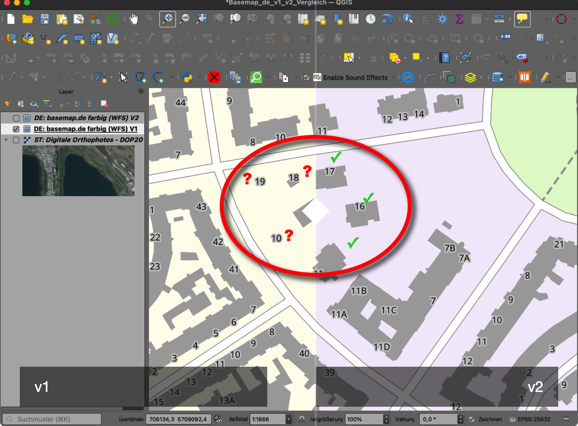
Basemap.de Vektor: Update auf v2 & neue Gebäude, ein Test https://geoobserver.de/2025/03/11/basemap-de-vektor-update-auf-v2-neue-gebaeude-ein-test/ #basemap #geoinfodok #gistribe #gischat #fossgis #foss4g #OSGeo #spatial #geospatial #opendata #gis #geo #geoObserver pls RT @BasemapDE

@horst724 ... der zweite Tipp (https://www.lokjo.com/) bietet (für meine Region) die aktuelleren Luft- bzw. Satellitenbilder an.
Ansonsten gibt es für amtliche #Karten (#Vektor und #Raster noch dieses empfehlenswerte #Portal auf #Bundesebene in #Deutschland:
Mehr Infos zum Projekt und zur Kartenauswahl:
https://basemap.de/
Fürs #Routing mit optional aktivierten #Verkehrsdaten taugt auch das Portal vom #ADAC unter https://maps.adac.de/ wirklich gut.
In der "3D-Beta Visualisierung von LOD2-Gebäuden" vom BGK / basemap.de sind endlich auch die Gebäude in Schleswig-Holstein in LOD2 zu finden.
Mitte Dezember 2024 waren sie noch nicht da.
Es gibt auch zwei Beispielanwendungen für MapLibre und Cesium JS, inklusive Code:
https://basemap.de/beta/beta-lod2/
#BKG #basemap #basemap_de #Kiel #SchleswigHolstein #MapLibre #Cesium #GIS #Karten

Die quartalsweise Aktualisierung der https://basemap.de Web Raster (Q1-2025) ist am 02. Januar 2025 Online gegangen
ℹ️ Die WMS- und WMTS-Dienste enthalten nun den Stand der Datenlieferungen der Länder bis Anfang September 2024.
#update #frischeKarten#Karten #amtlich #basemap
🎆 Die quartalsweise Aktualisierung der basemap.de Web Raster (Q4-2024) ist online.
🗺️ Der Kartendienst basemap.de Web Raster ist ein von Bund und Ländern gemeinsam entwickelter und im Auftrag der Länder bereit gestellter Internet-Kartendienst.
Nähere Informationen zum Produkt und dessen Aktualisierung können, wie gewohnt, unter https://buff.ly/3VYlXTC eingesehen werden:
#update #frischeKarten#Karten #amtlich #basemap

Mit https://basemap.de gibt es “Amtliche Karten von Deutschland“ - seit August 2022 und betrieben von einem Landesvermessungsamt. Weshalb also verwendet https://warnungen.bund.de #googleMaps? 🤮


"basemaps are a tesseract"
Not sure if I posted this before, but posting it again so I can find it by searching for "tesseract".
#Tesseract #Hypercube #GalaxyBrain #basemap #basemaps #cartography #maps #MapDesign

Fyi, @ruthpozuelo (and others)
The #python #matplotlib #basemap module is now fully back on track, and the deprecation warning on their documentation page was removed. Congrats to the maintainer.
https://matplotlib.org/basemap/stable/index.html
Python has now once again two major map-plotting libraries: #basemap and #cartopy.

Have you ever needed to download an insanely large #AGIS #basemap as a #png?
Maybe you need to make a print of a map on your AGIS server, but no longer have the original. Or maybe you want a really hi-res image for a film zoom effect.
Here's a tool to do just that.
It uses your public facing AGIS MapServer endpoint to download each tile, then assembles them into one large PNG image.