#Meteorological

2026-01-08

Gee, I wonder if Stupid Hitler will take the #USA out of the World #Meteorological Organization. He's so brilliant, all we need is for him to brandish a Sharpie pen to forecast #weather over the continental US.

Trump administration to exit 66 international organizations | AP News
apnews.com/article/united-nati

2025-12-03

Cloud Duvet over the Cleveland Hills

The morning sky was as clear as one could hope for December, though the Cleveland Hills had chosen to hide beneath a bank of cloud. One could call it an orographic cloud, if one wished to sound as if one had paid attention in geography lessons. The term comes from the Greek oros for mountain, which is rather generous for the Cleveland Hill ...

fhithich.uk/2025/12/03/cloud-d

#ClevelandHills #meteorological

2025-12-01

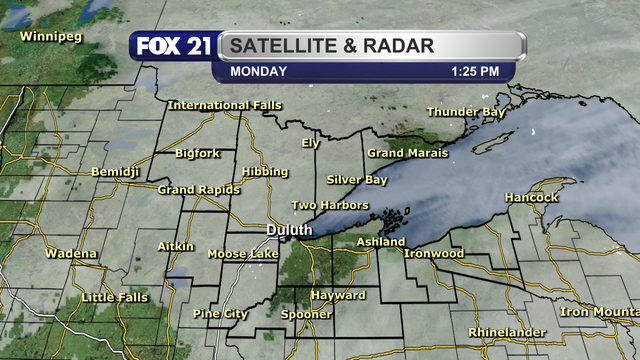
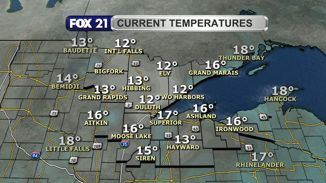
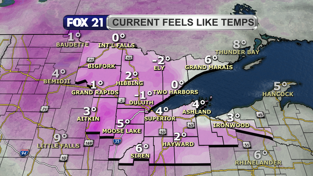
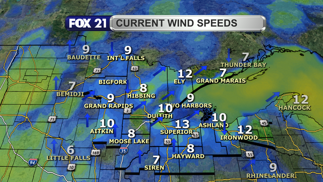
Happy #Monday afternoon from the #Northland!

Welcome to the start of #December and #meteorological #winter, and it definitely feels like the new #season with below average #temperatures.

At least we are getting some peeks of #sunshine out there, but not much.

#wxtooter #weather #wx #MNwx #WIwx #UPwx

The satellite and radar over the Northland at 1:25 p.m. on December 1, 2025, shows dry conditions across the region.  There is a spot of clear skies over parts of northwest Wisconsin, but the overall trend is cloud cover with very few breaks in them across the region.Temperatures in the Northland just after 1 p.m. on December 1, 2025, range from 12 to 17 degrees Fahrenheit.Feel like temperatures in the Northland just after 1 p.m. on December 1, 2025, range from 2-below to 6 degrees Fahrenheit.Wind speeds in the Northland just after 1 p.m. on December 1, 2025, range from 7 to 13 mph.  Wind direction is primarily from the southwest and south.
2025-12-01

NORTHLAND FORECAST FOR DECEMBER 1, 2025:

The start of #meteorological #winter and #December will be a #cold one for the #Northland.

Any #snow #showers will end Sunday night with lows in the single digits, but feeling like it’s below zero.

Monday will see a mix of #sunshine and #clouds as a light #breeze forms from the southwest. That won’t help #temperatures as highs stay in the teens.

VIDEO: fox21online.com/2025/11/30/sun

#wxtooter #wx #weather #forecast #MNwx #WIwx #UPwx

2025-11-30

Happy #Sunday afternoon from the #Northland!

The last day of #meteorological #fall is definitely feeling more like #winter.

Some periodic light #snow #showers will pass through, but the #cold #temperatures are settling in.

#wxtooter #weather #wx #MNwx #WIwx #UPwx

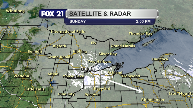
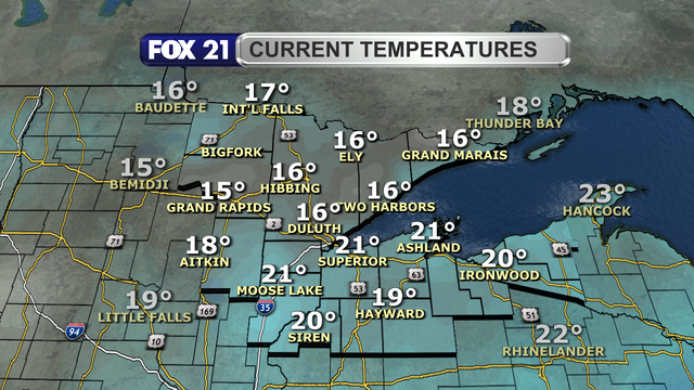
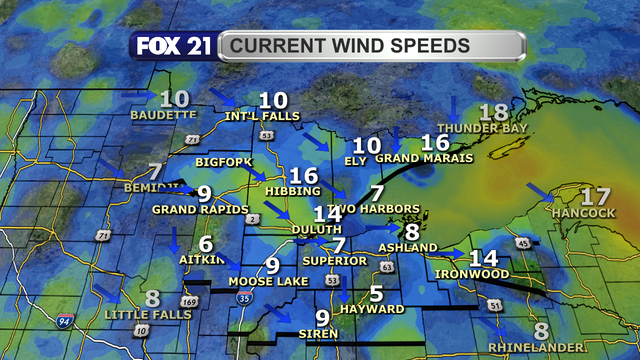
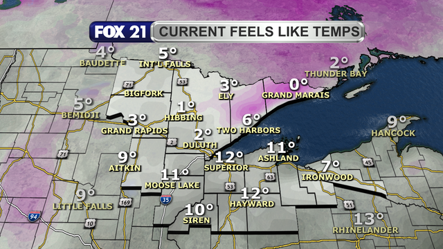
The satellite and radar over the Northland at 2 p.m. on November 30, 2025, shows a cluster of light snow showers passing over the heart of the region from northwest to southeast.  Cloud clover dominates the rest of the area with just a few peeks of sunshine poking through.Temperatures in the Northland just before 2 p.m. on November 30, 2025, range from 15 to 21 degrees Fahrenheit.Wind speeds in the Northland just before 2 p.m. on November 30, 2025, range from 5 to 16 mph. Wind direction is primarily from the northwest and west.Feel like temperatures in the Northland just before 2 p.m. on November 30, 2025, range from 0 to 12 degrees Fahrenheit.

www.nature.com/articles/s41... "results reveal a substantial #death toll from potential #future #extreme #heat events in #Europe; are based on historically observed #meteorological patterns combined with plausible twenty-first-century #global #temperature anomalies, making them realistic storylines"

Increasing risk of mass human ...

TinJarTinJar
2025-11-24

nature.com/articles/s41558-025

"results reveal a substantial toll from potential events in . These results are based on historically observed patterns combined with plausible twenty-first-century , making them physically realistic storylines of high-magnitude heat events"

2025-10-21

The #weather today is highly confused as to it's role in the #season of #fall, before the sun arose it was warm and windy and cloudy, now the winds have subdued themselves, the clouds have pushed on out, the sun is sitting low for this time of morning, and it is cooler than it was when it was dark out, but wait, this afternoon is supposed to be much warmer and partly sunny, and then a chilly night, the many swings in the #meteorological sense would indicate that the weather is having an identity crisis and is acting rather #manic, I think mother nature needs #counseling;

You can encourage my continued useless #commentary, random thoughts and ideas, and by doing so your helping to feed, house and clothe a #disabled man living in #poverty, $5-10-15 It All Helps, via #cashapp at $woctxphotog or via #paypal at paypal.com/donate?campaign_id=…

2025-09-07

“In the first place, “#meteorological #drought” is only a measure of how much #rain falls; the hotter temperatures associated with climate change have been increasing evaporation, which dries up more of that rain. And, … as #globalwarming increases evaporation in the arid West, it also increases #rainfall in the moist East, producing the flooding rains that have caused so much damage in regions like the Appalachians."

#ClimateChange

newyorker.com/news/the-lede/tr

Giuseppe MichieliGMIK69@mstdn.science
2025-09-06
2025-09-01

By the way, it is the start of a new month, and a new #meteorological season.

#Welcome to #fall in the Northern Hemisphere, and #spring in the Southern Hemisphere!

What can the #Northland expect? The continuing #cooldown from the #summer heat, but still plenty of #precipitation.

#wxtooter #weather #wx #MNwx #WIwx #UPwx

As we begin September, as well as meteorological fall, we will see the next 30 days cool down from the upper 60s and low 70s for highs to start the month, to the upper 50s and low 60s by the end of it.  Lows will cool from the upper 40s and low 50s to the upper 30s and low 40s.  Precipitation totals for the month should be about 3 to 4 inches, and it should be all rain.  However, a bit of snow such as a dusting has happened in the past.
2025-08-31

Happy #Sunday afternoon from the #Northland!

For most, today's #weather is a nice way to end #meteorological #summer with #sunshine, #warm #temperatures, and some #humidity in the air.

For a few, pop-up #showers and #thunderstorms are dampening this middle day of the #holiday #weekend.

#wxtooter #wx #MNwx #WIwx #UPwx

The satellite and radar over the Northland at 2 p.m. on August 31, 2025, shows a scattered line of showers and a few thunderstorms extending from west of the Twin Ports northeast along the cliff side of the North Shore, along with isolated showers in the Rainy River Basin and Boundary Waters region.  The rest of the region is seeing clear to mostly clear skies.Over the past 24 hours since the early afternoon hours of August 30, 2025, some spots in the northern half of the Northland have seen showers and thunderstorms passing through.  These "summer sprouted" precipitation has led to a few spots likely seeing over 1-inch of new rainfall.Temperatures in the Northland just before 2 p.m. on August 31, 2025, range from 68 to 81 degrees Fahrenheit.Wind speeds in the Northland just before 2 p.m. on August 31, 2025, range from calm to 12 mph.  Wind direction is primarily from the southwest and west.
2025-08-25

Happy #Monday afternoon from the #Northland!

It was a #chilly start to the day for late August, but a taste of what is to come next week when #meteorological #fall officially begins.

Despite some #clouds, there is plenty of #sunshine to enjoy the rest of today.

#wxtooter #weather #wx #MNwx #WIwx #UPwx

The satellite and radar over the Northland at 1:20 p.m. on August 25, 2025, shows simple cumulus clouds forming over the western half of the region, with clear skies for the eastern half.Temperatures in the Northland just after 1 p.m. on August 25, 2025, range from 59 to 66 degrees Fahrenheit.Low temperatures for the morning of August 25, 2025, ranged from 36 to 47 degrees Fahrenheit.  These are readings more common for early October compared to late August.Wind speeds in the Northland just after 1 p.m. on August 25, 2025, range from 3 to 15 mph.  Wind direction is primarily from the northwest and north.
2025-08-23

#StKitts and #Nevis is on alert as a #tropical wave is set to bring changes to the local weather, with the St.​ Kitts #Meteorological Services and the National Emergency Management Agency (NEMA) closely tracking its trajectory and potential impact. winnmediaskn.com/st-kitts-and-

St. Kitts and Nevis on Alert for Approaching Tropical Wave.jpg
Susan Villevillebooks
2025-08-23

📌 Closest inhabitants reside at a Chilean station on Isla Gonzalo, located 45 kilometers to the NW of the here, shaking is estimated to have reached intensity V (moderate)

🔹 A lonely lighthouse marks this as the southernmost habitation (outside of Antarctica), providing a point of reference for passing

👩🏽‍💻 If any of the readers happen to be in contact with these unusual lighthouse-keepers, let us know

📑 Hubbard/Bradley

earthquakeinsights.substack.co

2025-08-18

The UK #Meteorological Service - the Met Office - is a couple of miles down the road from here. (The adjacent #roundabout has a light show object of considerable size on it, which distinguishes it from other similar roundabouts, useful for orienting oneself. And shows colours related to the weather forecast. It caused a #storm - of protest - from the usual suspects.)

Since it moved here we have steadily had #records set in #weather.
That isn't going to stop.

edition.cnn.com/2025/08/16/wea
#hurricane

2025-07-31

515-Mile-Long #Lightning Megaflash Sets New World Record

A lighting flash that spanned from East Texas to an area near Kansas City in 2017 is officially the longest lightning strike ever measured, according to the World #Meteorological Organization

[talk about “blinding me with science”]

#science
scientificamerican.com/article

2025-06-01

Happy #Sunday afternoon from the #Northland.

This should be a fine #weather day for the beginning of #meteorological #summer with #clear skies, light #winds, and #warm #temperatures.

However, #wildfire #smoke from Canada is bringing #hazy skies and deteriorating #airquality levels.

#wxtooter #wx #MNwx #WIwx #UPwx

The satellite and radar over the Northland at 2 p.m. on Sunday, June 1, 2025, shows very little cloud cover over the region with no precipitation.  It does not show the smoke from wildfires burning in Canada that have flown south over the continental United States.The wildfire smoke in the atmosphere over the western Great Lakes region during the early afternoon hours of June 1, 2025, shows heavy levels over the region, with some moderate levels as one progresses east into the Upper Peninsula and eastern Wisconsin.  Air quality levels in the Northland are good for the moment, but they are forecasted to become poor by Sunday night and continue through Monday.Temperatures in the Northland just before 2 p.m. on June 1, 2025, range from 62 to 81 degrees.  There are a few pockets in the Twin Ports and North Shore regions where temperatures are in the 60s.Wind speeds in the Northland just before 2 p.m. on June 1, 2025, range from 5 to 8 mph.  Wind direction is primarily from the south and southwest, with a light lake breeze near Lake Superior.

Client Info

Server: https://mastodon.social
Version: 2025.07
Repository: https://github.com/cyevgeniy/lmst