
#capoeira #lifestyle #gainesvillefl #alachuacounty #bradfordcounty #unioncounty #marioncounty
#MarionCounty


Hype for the Future 115H: Central Ohio
Disclaimer This article is dedicated specifically to the areas surrounding Greater Columbus, with the exception of Greater Columbus itself. Most areas to the south and east have been covered separately or, if not, are likely going to be covered in the near future. Introduction Within the State of Ohio, the central region of the State is largely associated with the City of Columbus. Outside the city limits and suburban areas, many of which are positioned to the north and east, the general […]https://novatopflex.wordpress.com/2026/02/23/hype-for-the-future-115h-central-ohio/
Hype for the Future 114A: Village of La Rue, Ohio
Overview The Village of La Rue is located on the western edge of Marion County, Ohio, along the north-south axis of Route 37 throughout the community and area. Today, the community is officially attached to the Elgin Local School District.https://novatopflex.wordpress.com/2026/02/22/hype-for-the-future-114a-village-of-la-rue-ohio/
Hype for the Future 112K: Ohio State Route 98, Part One
Introduction Within the State of Ohio, Route 98 refers to a north-south state highway with a multifaceted route. This particular post specifically intends to represent exclusively the portion of the route from Waldo to Bucyrus, though the highway ultimately continues in a northeasterly direction as far as the Village of Plymouth along Route 61. Route Information The general trajectory of the highway between the communities of Waldo and Plymouth is a mostly straight line heading […]https://novatopflex.wordpress.com/2026/02/20/hype-for-the-future-112k-ohio-state-route-98-part-one/
Hype for the Future 112J: Ohio State Route 746
Overview Within the State of Ohio, Route 746 is a connector between the villages of Caledonia to the north and Ashley to the south. Today, the state highway is exclusively located in Marion and Morrow Counties, and the vast majority of the highway parallels the county line on the Marion County side by approximately one quarter of a mile. At the northern terminus is the Village of Caledonia, located along Route 309, the Harding Highway and former Route 30S, while at the southern terminus is […]https://novatopflex.wordpress.com/2026/02/20/hype-for-the-future-112j-ohio-state-route-746/
Hype for the Future 112E: Villages of Prospect and Waldo, Ohio
Overview Today, the Villages of Prospect and Waldo are each located on the southern side of Marion County, Ohio, both along Route 47. The Village of Waldo is located further east, at the eastern end of the highway along the more significant Route 23 between the Cities of Marion (north) and Columbus (south). Neither village contains a substantial population, though both are strategically located within close proximity to the City of Marion to the north, with the Village of Waldo along Routes […]Hype for the Future 112D: Green Camp, Ohio
Overview Green Camp is the name of a village and surrounding township located to the south of Big Island along Prospect-Upper Sandusky Road and to the southwest of the City of Marion along Route 739 in Marion County, Ohio. Today, the village and surrounding township remain quite rural, with services provided by the Elgin Local School District, the Village of Green Camp, the Township of Green Camp, Marion County, and the State of Ohio, depending on the particular location.https://novatopflex.wordpress.com/2026/02/20/hype-for-the-future-112d-green-camp-ohio/
Hype for the Future 112C: Big Island, Ohio
Overview Big Island is the name of an unincorporated county and associated township located immediately to the west of the City of Marion in Marion County, Ohio. Located on the rural fringe of Marion, the township is most directly accessible by way of Route 309 from east to west and Prospect-Upper Sandusky Road from north to south.https://novatopflex.wordpress.com/2026/02/20/hype-for-the-future-112c-big-island-ohio/
Hype for the Future 111M: Marion, Indiana vs. Marion, Ohio
Introduction Though the Cities of Marion in Indiana and in Ohio share a name, significant differences also exist between the cities in either state, including in terms of size, culture, personality, and related traits. The city in the State of Ohio continuously records a larger population than the city located in the north-central portion of the State of Indiana, with the Ohio community around one hour north of the City of Columbus and the Indiana community around one hour south-southwest of […]https://novatopflex.wordpress.com/2026/02/19/hype-for-the-future-111m-marion-indiana-vs-marion-ohio/
Hype for the Future 101L: City of Lebanon, Kentucky
Overview The City of Lebanon is situated within Marion County, Kentucky, and serves as the county seat. A national cemetery is located nearby to the southwest, and to the northeast, the community is also home to the Kentucky Cooperage, in which bourbon whiskey barrels are produced. As the county seat, Lebanon is bound to have infrastructural supports to serve the people and community associated with the Commonwealth. To the northwest is the community of Loretto, home to the Holistic Hippie […]https://novatopflex.wordpress.com/2026/02/09/hype-for-the-future-101l-city-of-lebanon-kentucky/
Hype for the Future 100Q: Indiana State Road 135
Introduction Within the State of Indiana, State Road 135 is situated to the east of SR 37 but to the west of Route 31. SR 135 traverses the regions of Central and Southern Indiana, exclusively south of Indianapolis, until reaching the Ohio River and thus being forced to become Kentucky State Route 79. Attractions Within the Southern Indiana portion of State Road 135, travelers can expect to pass through iconic historical communities such as Corydon, Salem, and Vallonia on the journey […]https://novatopflex.wordpress.com/2026/02/08/hype-for-the-future-100q-indiana-state-road-135/

Untitled photo, possibly related to: Bean pickers' camp in grower's yard. No running water. Marion County, near West Stayton, Oregon. See general caption number 46
#MarionCounty #WestStayton #Oregon #E-8520 #undefined #photography #DorotheaLange

Untitled photo, possibly related to: Oregon, Marion County, near West Stayton. Migrant pickers harvesting beans. Farm people came from South Dakota
#Oregon #MarionCounty #WestStayton #SouthDakota #Hebrew #undefined #photography #DorotheaLange

Oregon, Marion county, near West Stayton. Many children work in the bean harvest, as in the Oregon hop harvest. See "Pick for your supper." Sidel, Nation Child Labor Committee. General caption number 46
#Oregon #Marioncounty #WestStayton #Pickfor #DorotheaLanges #undefined #photography #DorotheaLange
![The image is a black and white photograph showing an individual, possibly a young girl or woman, wearing a wide-brimmed straw hat with flowers tied around it. She has on a plaid shirt tucked into dark trousers, suggesting practical workwear suitable for outdoor labor. The person carries a large wooden bucket in one hand and appears to be standing amidst what looks like bean plants filled with beans ready for harvest, indicative of an agricultural setting.
The individual is smiling towards the camera, radiating positivity despite potentially strenuous activity. Her posture suggests she's taking a break or pausing momentarily from her work. The background is blurred but reveals more vegetation and possibly other crops, consistent with a farm environment during harvest season.
Additional context provided indicates that this scene likely takes place in Oregon, Marion county near West Stayton, where children commonly participate in the bean harvest like they do for hop fields as seen in "Pick for your supper." The image is associated with Dorothea Lange's work and carries a general caption number 46. This photograph may be part of her documentation on child labor conditions during that time period.
This setting highlights rural agricultural life, particularly the role women played in farming communities, reflecting historical aspects of farm work and family involvement in a [...]](https://files.mastodon.social/cache/media_attachments/files/115/992/552/445/879/686/original/9ac1ed9c2b6bb0a0.jpeg)
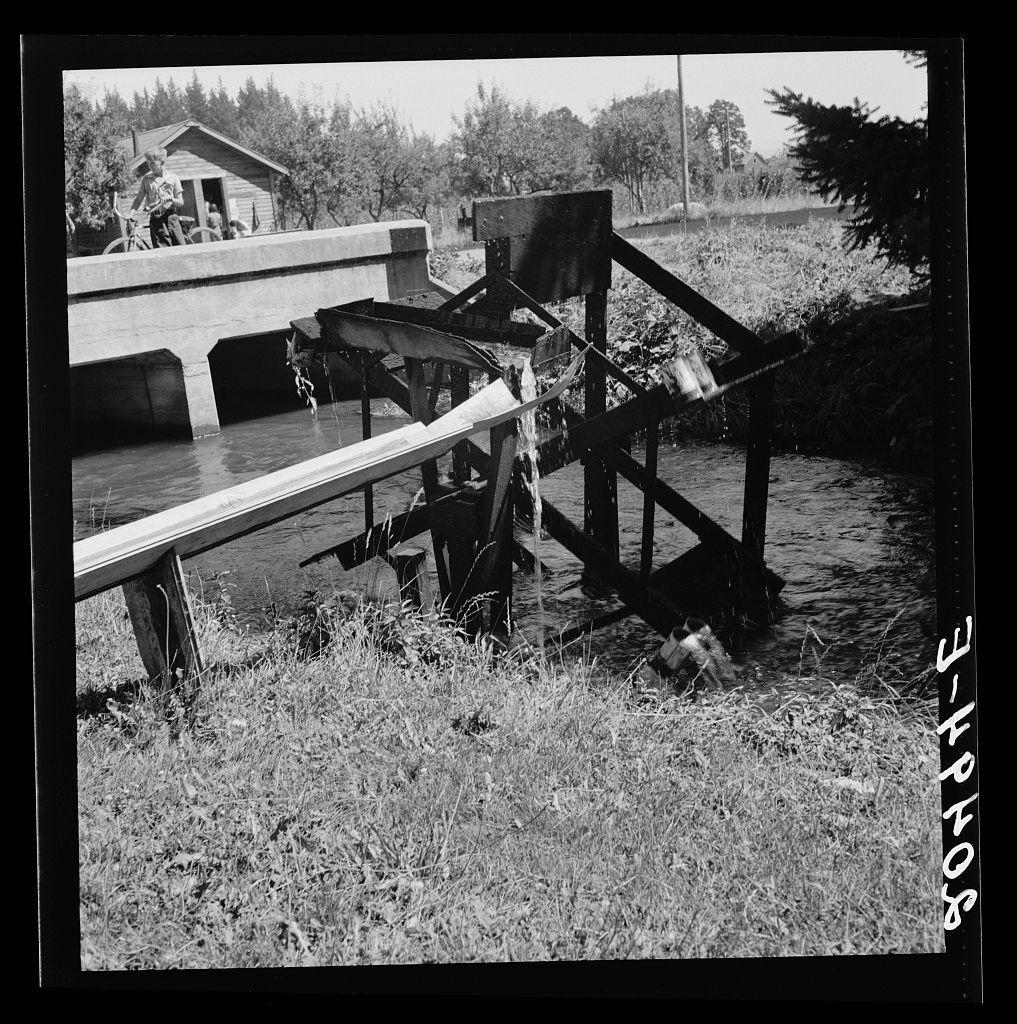
Untitled photo, possibly related to: Oregon, Marion County, north of West Stayton. Waterwheel for field irrigation in the bean country
#Oregon #MarionCounty #WestStayton #SHOENHEIDE #undefined #photography #DorotheaLange
Untitled photo, possibly related to: Oregon, Marion County, near West Stayton. Bean pickers' children in camp at end of day
#Oregon #MarionCounty #WestStayton #DorotheaLange #undefined #photography #DorotheaLange
![The image is a black and white photograph featuring eight individuals, including adults and children, gathered outside near what appears to be temporary housing. On the left side of the photo stands an older man in overalls with suspenders, wearing a hat, beside him another person dressed casually; both are positioned next to an old-style automobile that seems well-worn but still functional. In front of them stand two women and three children, all looking directly towards the camera or slightly away from it. The woman closest is standing behind the older man in overalls, while a child with their hand near mouth appears at her side.
On the right-hand side stands another young boy who seems to be alone apart from an older individual seated on what looks like wooden planks by himself; there's also a younger girl sitting further back. The background features a small rustic-looking structure with visible windows, and beyond it is sparse vegetation indicating perhaps farmland or rural setting.
The photograph carries the text "3-178406" at its top edge. Below the image, in smaller print, reads: "Dorothea Lange," suggesting that this might be a work by Dorothea Lange known for her documentary photography capturing moments from social history, particularly during times of hardship and war.
The overall atmosphere conveyed is one of simplicity, possibly depicting rural life or ag [...]](https://files.mastodon.social/cache/media_attachments/files/115/991/579/754/492/191/original/c151418444f2436e.jpeg)
Untitled photo, possibly related to: Oregon, Marion County, near West Stayton. Large private auto camp in woods at end of day. Bean pickers from many states. Refer to general caption 46
#Oregon #MarionCounty #WestStayton #undefined #photography #DorotheaLange

Untitled photo, possibly related to: Oregon, Marion County, near West Stayton. Weighing beans at scales on edge of field. Rate: one dollar per 100 pounds. General caption 46
#Oregon #MarionCounty #WestStayton #100pounds #undefined #photography #DorotheaLange

Weighing scales at edge of beanfield. Near West Stayton, Marion County, Oregon. General caption number 46
#WestStayton #MarionCounty #Oregon #undefined #photography #DorotheaLange

Beanfield. Weigh scales, pickers, and sacked beans at edge of field. Near West Stayton, Marion County, Oregon. General caption number 46
#Beanfield #WestStayton #MarionCounty #Oregon #undefined #photography #DorotheaLange

Client Info
Server: https://mastodon.social
Version: 2025.07
Repository: https://github.com/cyevgeniy/lmst