#LEJOG

2025-03-30

Latest update on my (virtual) Lands End to John O'Groats walk. I know I'll forget to post tomorrow (the last day of the month) so updating today.

This month I managed 145 miles, which is my highest total so far. Had a few days away mid-month which let me get some extra walks in.

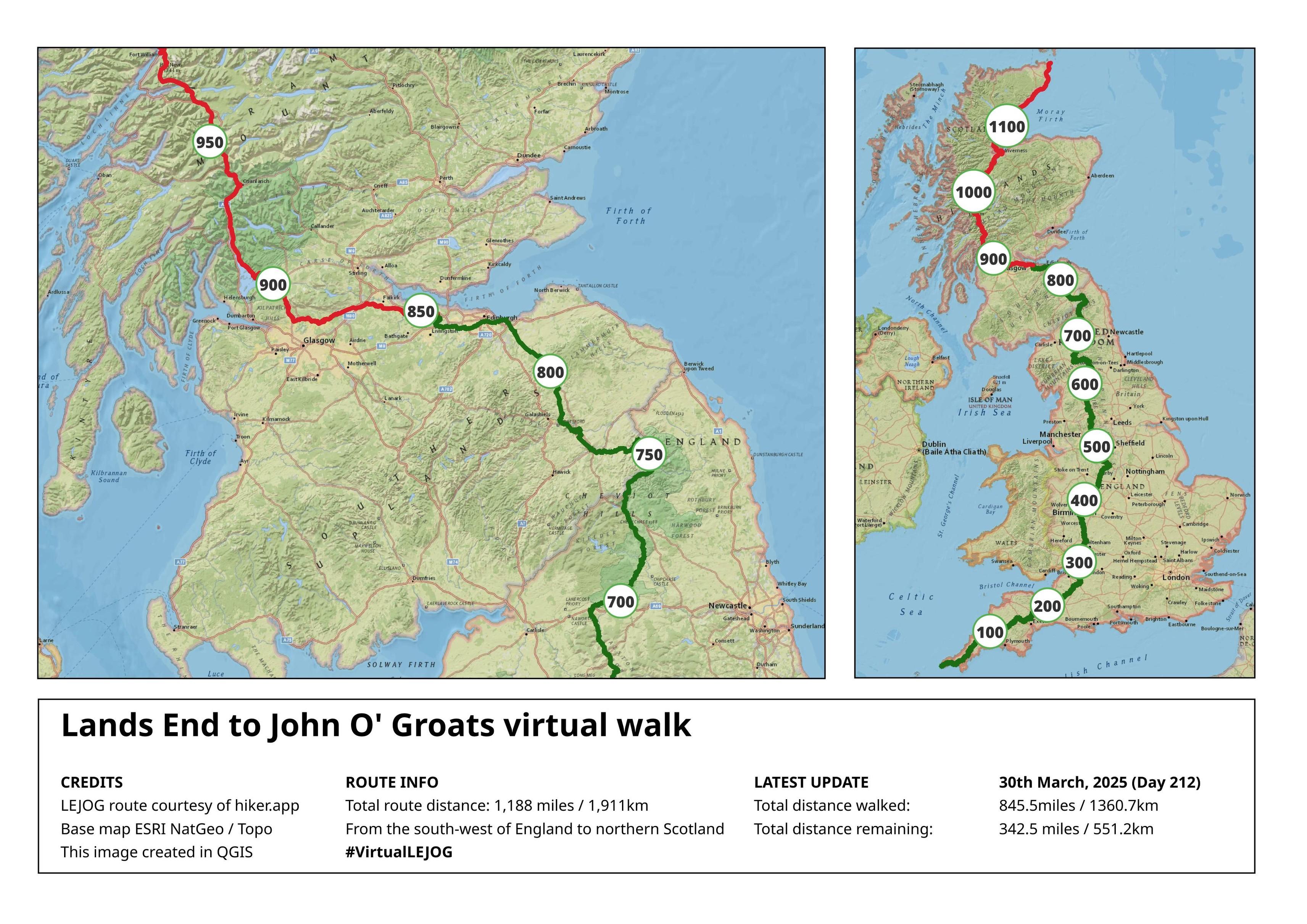
This takes me to 845miles total and, were I actually walking the #LEJOG route, I'd be just outside Linlithgow, to the west of Edinburgh.

Less than 350 miles to go! 🦵

#walking #VirtualWalk #VirtualLEJOG

There are two maps shown in the image, and they are titled 'Lands End to John O' Groats virtual walk'.

One map is of the whole of the UK mainland with a trail running from the south west of England to northern Scotland. The trail has 100 mile markers along it. The total trail distance is 1188 miles / 1907km. Some of the trail is green, showing the route already walked, with the remainder coloured red.

The other map is a close up version of central and southern Scotland showing the same trail, with a closer view on where the 'walked' area ends.

There is some text at the bottom summarising the distances already walked, which are:

845.5 miles / 1,360.7km

The distance remaining is:

342.5 miles / 551.2km
Cycle Review Newscyclereview
2025-03-08

Pedal the Future: Cycle Britain Ltd.’s Epic E-Bike Journey from Lands End to John O’Groats

...#CycleBritain Source link Alan Little, Director of Cycle Britain Ltd, approached us in January 2021 with an ambitious idea: to create a fully supported electric…

cyclereview.co.uk/pedal-the-fu

2024-11-15

Back in 2003, I walked 1111 miles from Land's End to John o'Groats. As you do.

21 years later, I've been interviewed by LEJOG legend Dave Felton for his new monthly podcast, LEJOGcast.

We had great fun, and I think it shows! I hope you like it.

You can listen to the podcast here:

shows.acast.com/lejogcast-the-

And you can read the full story of my own walk here, where you can also find loads of information for those thinking of doing this epic walk themselves:

landsendjohnogroats.info/

#walking #hiking #lejog

2024-09-01

Started a new challenge this weekend, where I'm doing a virtual walk from Lands End to John O' Groats (LEJOG) in the UK.

To be clear, I'm not actually walking this route. Instead I'm keeping track of the distances I do walk and mapping the miles onto the #LEJOG trail in #QGIS.

I want some motivation to keep walking through the winter months and thought this might be a fun way to do it.

So some factoids from the recent ride:

Total ascent was 24.5km, about 2.5 Everest's.
Averaged at 90km/day.
95h of cycling overall. Max speed 60kph. Getting lost: 3 times. Rabbits seen 47. Swifts seen infinity plus one. Punctures: 12. New Brake pads: 1. Crashes: 1. Cyclists met 22 (8 LEJoG).

Route planning via cycle.travel/ was really useful.

#LEJoG

Day 20: 1813km

All dun(net head).

The day was mixed between sweltering in the sun and freezing in the wind, as befits the North coast.

Realised the route ends with a steep climb into Dunnet Head, dodging motorhomes on the single track road which made for dinner stop start adventures.

Did a wander to the Duncansby Stacks which is much better than the nearby JoG.

Next up, three days of driving to get home. Don't expect updates other than "engine go brrrum"

#LEJoG

Day 19: 1745km, ?? counties

Tyre ran out of sealant so short day today, but wasn't planning on ending anyway.

Very hot up here, 24° and full sun.

The north coast is very empty of anything (including open bike shops) so very quiet. You can't really express the emptyness, but I bet it's very lonely here as well.

Headed to the beach instead, made a sandcastle, paddled in the northest sea of the mainland and had a nice picnic, now watching the sun go down.

Tomorrow, 66.78km and done.

#LEJoG

Day 18: 1694km, ?? counties

Uneventful day. The A roads here have passing places and potholes. Let's not talk about some of the B roads.

There was a neat pedestrian bridge along a railway crossing that made a way to avoid some (proper) A roads.

Stopped off at the falls of insh, where the salmon were not jumping upwards, so it was just a neat waterfall.

#LEJoG

2024-06-24

I was scrutinising a #BikeTouring rig outside a cafe in the #LakeDistrict yesterday. Turns out it belonged to a young person #CycleCamping the #LEJOG over a 5 week period. Their humility, enthusiasm and friendliness quite restored my faith in (some of) humanity. I hope the weather stays fine for them.

Day 17: 1596km, ?? counties

Fun day. Kept my energy until at least the 75km mark, but somehow an unexpected 20km materialized at the end of the day.

Highland pride was a fun little detour, made easy by the bike route taking me past the start about 10 mins before it started.

After that it was being blown sideways in the wind and a-road cycle paths, which just appeared to go on forever.
#LEJoG

Day 16: 1493km, 17 counties.

Drumochter summit today, a wild and lonely place. Even though following the A9 the cycle path was cleverly just to the side or down from the road so there wasn't any disturbance.

@malgrandaleono was very happy with their coffee at 450m, warmed us up a treat.

#LEJoG

A ruined fort in the countryside. A path leads up with a few people on.A tiny lion with a coffee cup, looking out over a cycleway above hills and countryside.A sign:

WARNING
Drumochter Summit
Cycle track climbs to 457m
Weather conditions deteriorate without warning and can be severe even in summer
No food or shelter for 30km
No snow clearance or gritting on cycle track.

Day 15: 1407km, 16 counties.

Very pleasant riding today. Felt very Scottish. Did a lot of pine marten territory but didn't see any of them.

Enjoyed the Tay valley after Dunkeld, nice and #quiet with only the birds and water for company. I think it might be another temperate rainforest like the lydford gorge.

Tomorrow up and over the highest point on the route, which I think puts me in the Scottish Highlands for the next few days.

#LEJoG

Day 14: 1321km, 15 counties, maybe.

It's getting hard to count the counties, I'm starting to oscillate between some now.

Saw @Ninji for dinner in Glasgow which was neat. Had been hankering for some Japanese for a while.

Highlight was the forth rail bridge from the semi-closed forth road bridge. Am on the final stretch now, the various routes to JoG are coalescing into one true finish.

Scotland does good sculpture. And the lochs have waves and beaches at 100m above sea level.

#LEJoG

The forth rail bridge, a red cantilever bridge, it sits above a large estuary. In the distance is a small town and in the foreground is a tiny lion.A beach and inland lake with waves. It's a sunny day.A road that goes on and on, with green fields and hedges to each side.A rusted metal rose flower about 2m high, on a grass area by a cycle path

Day 13: 1224km, 14 counties

A simple day but a lot further north. Woke up early and spent the first two hours following the B7076 over a pass. Everything was just the same, broken up only by potholes or the occasional roadworks.

Saw some lamb on the road and ended up bye ruins of cadzow castle. Best name.

#LEJoG

A bridge across a river valley with a castle ruin on the far side. It's large, maybe 50m,  compared to the two people waking across it.Another star topped pointy sculpture, this one in nautical stripes of blue and white.A work of art? of bicycle signs arranged in a half-globe.

1137km, 13 counties. Finally in Scotland. Fixed the brakes on my bike in Carlisle.

Gretna green was a bit lame. Road was good for northerly progress but nothing to write about. Lots of straight roads and generic countryside. And pig smells.

And finally, It's a lovely afternoon in the service station and we are horrible geese ^^

#LEJoG

Twenty geese on the roadside with road furniture around them. In the near distance two cars are being blocked by geese.A curiously shaped yellow roadside erection with a bent star at the top. It's labelled 7 and has distances to various places on it.A roadside with two cycle signs. One says North, the other South.

Day 11: 1046km, 12 counties

Unintended short day, due to a mix of punctures and rain on the horizon. Decided to just not get wet and save up energy for tomorrow.

🐞-fren came along for a ride for about 10km. Hope they intended to.

Leo also got a shieldbug fren, who didn't come for a ride.

#LEJoG

A bike cockpit with Garmin computer and a tiny two spot red ladybird on the handlebar tape.@leonerd looking over his glasses at a shieldbug who's taken up residence atop one lens.Country hills with ominous low cloud in the distance.

Day 10: 991km 12 counties

It did a rain. We had food to compensate and wait out the lightning. The calm did let me get another 20km, but then it downpoured and then a 4x4 decided to intentionally splash me head to toe. I know what road juice tastes like now.

Maybe, just maybe, tomorrow we go to Scotland.

Highlights:

River Lune valley with the coloured bridge.

This waterfall that I don't know where it was any more, and this weird fish thing that reflects our love for old royalty.

#LEJoG

A coffee cup in front of a bike in front of a old stone bridge in front of a river in front of a new bridge painted peach and grey. All is in a wooded valley.

The coffee cup has spilled down the side.A water fountain in the shape of a fish, dedicated to a long dead queen of England. The water is rusty and flooding on the floor.A waterfall cascade from under an arched bridge, surrounded by vegetation.

Day 9: 831km, 11 counties

That's over half way in 9 days travelling. Not sure if Scotland is going to be more work, but I think there's at least a few straight and level days to come.

Oddly the highlight from today was post cycling, we walked to the singing ringing tree above Burnley.

Oh, and cycling through the town they named after me.

#LEJoG

A sculpture of metal tubes in a whirlwind shape on a hill top. In the distance are wind turbines and in the foreground is a figure looking away.A (real) road sign, "Delph conservation area. Please drive carefully"

Day of rest again. Heard back from the interview successfully so I'm generally happy. Just need to work out how to get south fast enough at the end for the face to face.

Did a little walking on the hills, above Glossop though. Also remembered how to do the whole sandpaper glue wait patch thing on the inner tubes I've punctured so far.

#LEJoG

A panoramic view over a style onto a valley. It's grey and bleh, and you can imagine it's cold and windy too.

Day 8: 753km, 10 counties.

Is greater Manchester even a county? Idk. Very enjoyable but long day. Highlights were the goyt valley, another community-turned-resevoir. A local on their way home showed me an alternative which was fast^Wfunner.

All went uphill later when the last stretch turned into a km of 12% hill, which was not wanted at that time.

Before that was the tissington trail, which was a 30km off-road section of the day.

I think this is the 9th ex-railway I've used so far.

#LEJoG

A knitted cover for a post box, with flying bees and the slogan "bee happy"A road though the hills of the peak District, with countryside views.A huge, long lit tunnel, ex-railway with a tarmac path up the middle.

Client Info

Server: https://mastodon.social
Version: 2025.07
Repository: https://github.com/cyevgeniy/lmst