#CubCrafters

Aerobuzz / JumpSeataerobuzz@piaille.fr
2026-02-03

Un câble près d'une rivière a été fatal à l'équipage d'un Carbon Cub en train d'évaluer l'avion pour une chaîne Youtube. Le constructeur stoppe en conséquence son programme de location d'avions aux médias. #Cubcrafters #CarbonCub #Youtuber #Crash

aerobuzz.fr/breves-aviation-ge

Marcus Jaschenmjaschen
2025-12-13

Konstanz EDTZ → St. Gallen–Altenrhein LSZR

Mit dieser Etappe ist die Reise entlang von Ostsee- und Nordseeküste sowie den Rhein hinauf zu Ende.

A small white single-engine airplane with red accents on the landing gear and wingtips is flying horizontally at a low altitude above a deep blue body of water. It hovers near the shoreline where the water meets a dense forest of green trees. The surrounding context includes a coastal landscape: the forest transitions into suburban neighborhoods with visible streets and houses, then into an urban area with clustered buildings extending toward the horizon. Multiple water bodies, including smaller inlets and a larger central lake, fill the background. Beyond the city, open land with fields and distant hills stretches under a clear blue sky. The scene captures a bright, sunny day with no clouds visible, emphasizing the airplane’s flight over the water and coastal terrain.A small plane with a white fuselage and gray wings flies at low altitude, positioned centrally in the foreground. Its wings extend horizontally, and the tail section is visible. The aircraft is in flight over a dense urban and industrial landscape. Below, the scene features residential districts with red-tiled roofs, large industrial warehouses with brown roofs, and a prominent lake on the right. The background includes expansive green agricultural fields, dense forests, and distant hills under a clear blue sky. A runway is visible in the middle distance, indicating an airport nearby. The overall setting is a bustling city area adjacent to a large body of water, surrounded by rural farmland and natural terrain.A small single-engine aircraft with high wings, primarily white with a red stripe along the fuselage, displays the registration "D-MJXY" on its side. The plane is flying at low altitude over a large body of calm blue water, landing gear fully extended downward. The surrounding context includes an expansive water surface, a narrow landmass along the water's edge featuring a patchwork of green and brown agricultural fields, and distant mountain ranges with visible snow caps under a clear, light blue sky. The scene depicts a smooth flight above a coastal or lake region with mountainous terrain on the horizon.From inside the cockpit of a small fixed-wing aircraft, the windshield frame forms two diagonal black bars that frame the view. The aircraft is in flight, as evidenced by the clear blue sky overhead and the distant landscape. Outside, a large body of water—likely a lake or sea—occupies the right side, bordered by rolling green mountains with scattered urban development to the left. Distant snow-capped peaks rise on the horizon under a cloudless sky. The cockpit’s instrument panel includes visible text: "V0 87 MPH (CAS)", "Vne 81 MPH (CAS)", "MAX DEMONSTRATED CROSSWIND 11 KNOTS", and labels for navigation and communication systems like "NAV 1", "COM 1", "AUTO". A horizontal white bar with a downward-pointing arrow is centered above the windshield. The aircraft appears to be cruising at altitude, with the surrounding terrain and water visible through the clear cockpit glass.
Marcus Jaschenmjaschen
2025-12-12

Bremgarten EDTG → Konstanz EDTZ

Vorletzte Etappe des Trips den Rhein stromaufwärts.

White aircraft engine labeled NXCUB, with "NX" in red and "CUB" in gray lettering, is the primary object. The engine is part of a flying aircraft, viewed from a forward-facing perspective indicating flight. The context shows the aircraft positioned above a sprawling urban area dominated by a winding blue river cutting through the city. Below, there are dense building clusters, industrial zones, winding roads, green fields, and distant rolling hills under a clear blue sky. The scene captures a sunny day with excellent visibility, highlighting the city’s layout and natural surroundings from an elevated vantage point. The engine's placement in the foreground, positioned left, emphasizes the aerial viewpoint over the detailed terrain.The cockpit of a plane. It is in flight, with flight instruments active and displaying navigation data. The context is a clear blue sky view outside, showing a vast landscape of patchwork agricultural fields, a dense urban area,  the Airport Zurich and distant mountain ranges. On the interior panel, text reads "MAX DEMONSTRATED CROSSWIND 11 KNOTS" near the windshield. The instrument display shows labels including "BRG 090°", "DIST 4.9", "NAV 2 108.40", "COM 2 124.850", "SPRTL", and "WPT", indicating standard aviation navigation and communication parameters. The cockpit's interior features a blue display screen, multiple control knobs, and a white wing section visible through the windshield. The surrounding landscape includes varied terrain with green and brown fields, a clustered city, and snow-capped mountains under a bright, cloudless sky.A small, single-engine, high-wing aircraft with a white fuselage, red stripe, and registration number D-MJXY. It has a white tail, gray wings, and red landing gear. The aircraft is flying at a low altitude in level flight. The scene shows a clear blue sky above a landscape with a winding river flowing through a city with dense buildings, roads, and industrial areas. Green fields and distant hills surround the urban region, with highways visible near the river. The horizon displays rolling hills under a cloudless sky.This image presents a first-person cockpit view from a small single-engine aircraft in flight. The object is the aircraft's cockpit, featuring two black support struts framing the forward window, a white nose cone, and an instrument panel with multiple gauges and a digital display. The action involves the aircraft flying at altitude, with the viewpoint looking directly ahead over the landscape. The context includes a winding blue river cutting through green and golden farmlands, forested hills, and a small town, all under a clear blue sky with distant mountains on the horizon. Important text elements on the instrument panel include "ON", "IN USE", "ALT", "US95", "0494", "1.5", "NAV1", "108.40", and "COM2", "124.850". The scene depicts a serene aerial perspective over a detailed rural environment.
Marcus Jaschenmjaschen
2025-12-11

Forchheim EDTK → Bremgarten EDTG

Small white single-engine airplane with a high-wing configuration and white tail is the central object. The aircraft is in level flight, propeller spinning, with faint smoke trails visible behind it. The action of flying occurs at moderate altitude, with the plane positioned slightly below a layer of scattered white clouds. The context includes a detailed landscape below: expansive agricultural fields in varying shades of green, brown, and tan form a patchwork pattern, interrupted by a winding dark-blue river and scattered clusters of urban areas with dense building structures. Major roads connect these settlements, and numerous small water bodies dot the terrain. Above, the sky features a mix of fluffy white clouds against a blue backdrop, with the horizon showing distant land and more cloud layers toward the top. The scene conveys a clear day with ample sunlight, emphasizing the contrast between the aircraft’s motion and the detailed, colorful landscape beneath it.Aircraft cockpit view from a single-engine plane, with a black windshield framed by two dark support struts. The aircraft is in flight, navigating through a layer of white clouds under a bright blue sky with scattered, wispy clouds. Below, the terrain includes a mix of urban areas with buildings, green agricultural fields, a river, and coastal water bodies. Inside the cockpit, digital displays show flight data: altitude 7000 feet, airspeed 132 knots, and navigation information including "US87", "186", "29.3", "NAV 1", "COM 2", and "WPT". Additional control labels such as "PULL ON", "ALT AIR", and "ON" toggle switches are visible. The scene captures the aircraft at high altitude, providing a clear perspective of the sky and ground.A white single-engine propeller airplane with red accents is flying through a layer of white, fluffy clouds. The aircraft is positioned centrally in the frame, with its landing gear visible, indicating it is in a low-altitude flight. Below, a sprawling city unfolds, featuring a prominent river system with multiple dark blue channels, industrial districts with warehouses and factories, dense residential neighborhoods, and agricultural fields stretching into the distance. The sky is bright blue with scattered cloud formations, and the terrain below includes a mix of urban development, green spaces, and rural areas. The overall scene depicts a clear day with the airplane navigating above the cityscape, highlighting the contrast between the developed urban zones and the surrounding natural and agricultural regions.A small white single-engine airplane with a red stripe along its fuselage is flying at low altitude over a sprawling urban area. Below, the city features a dense grid of buildings with red-tiled roofs, winding roads, and scattered green spaces including parks, fields, and patches of farmland. In the distance, rolling green mountains rise under a partly cloudy sky, with valleys and rural landscapes visible beyond the urban sprawl. The scene combines urban infrastructure with natural terrain, captured from an aerial perspective that highlights the plane’s proximity to the cityscape and the surrounding mountainous region.
Marcus Jaschenmjaschen
2025-12-10
Cockpit of a small aircraft, viewed from the pilot’s perspective, with dual windshield struts forming the forward frame. The aircraft is in flight, moving over terrain under a cloudy sky. The cockpit features a central digital display showing flight data. The display also includes a map with green terrain, blue water for the river, and a purple navigation route. Surrounding the display are switches. The context reveals a landscape below with a winding river, patchwork fields in green and brown, and scattered towns with red-tiled roofs. The sky is overcast with layers of clouds, indicating daytime flight conditions.A white single-engine propeller aircraft with a high-wing configuration and red accents is flying low over a forested landscape. The plane, positioned left of center, moves horizontally. Below, dense green trees cover the terrain, with multiple intersecting highways visible—marked by lanes and some vehicles, including a yellow car. In the distance, an race track complex (Hockenheimring) features paved ways and structures like a large and smaller buildings, partially surrounded by the forest. The scene is captured from an elevated perspective, highlighting the contrast between the lush greenery, gray asphalt of the roads and the race track, and the white airplane.A white and red single-engine propeller plane with the registration number DMJXY is flying low with landing gear extended, approaching a runway at an airport complex. The aircraft moves horizontally over the airport, which features multiple runways, large hangars, industrial buildings, and parking lots. To the left, a winding river with tree-lined banks and small islands flows through the scene, separating the airport from distant agricultural fields, scattered forests, and open farmland. The landscape extends toward the horizon under an overcast sky, with patches of urban development, residential areas, and additional industrial zones visible. The overall environment combines aviation infrastructure, waterways, and mixed land use, with the river creating a natural boundary between the airport and surrounding terrain.The image shows the interior of a single-engine light aircraft cockpit, centered on the pilot’s perspective. The main object is the cockpit’s instrument panel, featuring a central digital display surrounded by switches and knobs. The aircraft is in flight at low altitude, approaching a runway for landing. Contextually, through the windshield, a paved runway marked “16” extends directly ahead, bordered by well-maintained green fields, scattered residential and commercial buildings, and a winding river that cuts through the terrain. Beyond the runway, the landscape includes dense forests, patches of agricultural land with varying green and brown hues, and urban areas with numerous houses and roads. The sky is overcast with light, diffused clouds, casting soft illumination over the scene. Inside the cockpit, the digital display shows flight data including “USN81,” “18.6,” “111.5,” “103.5,” “140,” “22.0,” and “114.4.” The instrument panel features switches labeled “ON,” “PULL ON,” “ALT AIR,” “ON USE,” “MAN,” “STEADY,” and numerical markings “10,” “15,” “5,” “0.” The aircraft’s nose is visible through the windshield, angled toward the runway, confirming the landing phase.
Marcus Jaschenmjaschen
2025-12-09
The image depicts a serene rural landscape viewed from an aerial perspective. In the foreground, there is a small, single-engine aircraft flying low over a patchwork of agricultural fields. The fields are divided into various sections, showcasing different crops or stages of cultivation, with some areas appearing green and others yellow, indicating different types of vegetation or harvest readiness.

In the middle ground, there is a small village or town with clusters of houses and buildings. The architecture appears to be typical of a rural setting, with some houses having red roofs. The village is surrounded by more fields, and there are trees scattered throughout the area, adding to the greenery.

The background features a broader expanse of farmland, with additional fields and some trees. The sky is overcast with a mix of clouds, suggesting a cloudy or possibly early morning or late afternoon setting. The overall scene conveys a peaceful and idyllic countryside environment.The image appears to be a screenshot from a flight simulation game, likely Microsoft Flight Simulator, given the style and interface. The view is from the cockpit of an aircraft, showing the pilot's perspective. The cockpit includes various flight instruments and controls, which are typical in flight simulators.

The scene outside the aircraft shows a landscape with a river running through it, surrounded by fields and urban areas. The weather appears to be overcast, with a gray sky and possibly some light precipitation, as the landscape looks somewhat muted and the sky is dark.

The river is a prominent feature in the image, cutting through the landscape and reflecting the overcast sky. The fields are patchwork, indicating agricultural use, and there are some buildings and structures visible, suggesting the presence of a town or city nearby.

The overall atmosphere of the image conveys a sense of calm and tranquility, with the vastness of the landscape and the overcast sky creating a serene setting. The image is likely taken during a flight over a rural or semi-urban area, with the river serving as a natural dividing line between different land uses.The image appears to be a screenshot from a flight simulation or a 3D city model, showcasing an aerial view of a city. The city is surrounded by agricultural fields and a river runs along the right side of the image. The urban area is densely packed with buildings, roads, and some green spaces. There is a small airplane visible in the sky, flying over the city. The overall atmosphere suggests a cloudy or overcast day, as the sky is dark and the lighting is subdued. The image captures a detailed and realistic representation of the city and its surroundings.The image depicts an aerial view of a landscape featuring a small aircraft flying over a river and industrial areas. The aircraft appears to be a single-engine, high-wing plane, possibly a vintage or classic model, given its design. Below the aircraft, there is a river running through the scene, with a small boat visible on the water. The surrounding area includes a mix of industrial facilities, such as factories and storage tanks, as well as patches of green fields and urban development. The overall setting suggests a location near a city or town, with a mix of natural and industrial elements. The sky is overcast, adding a muted tone to the image.
Marcus Jaschenmjaschen
2025-12-08

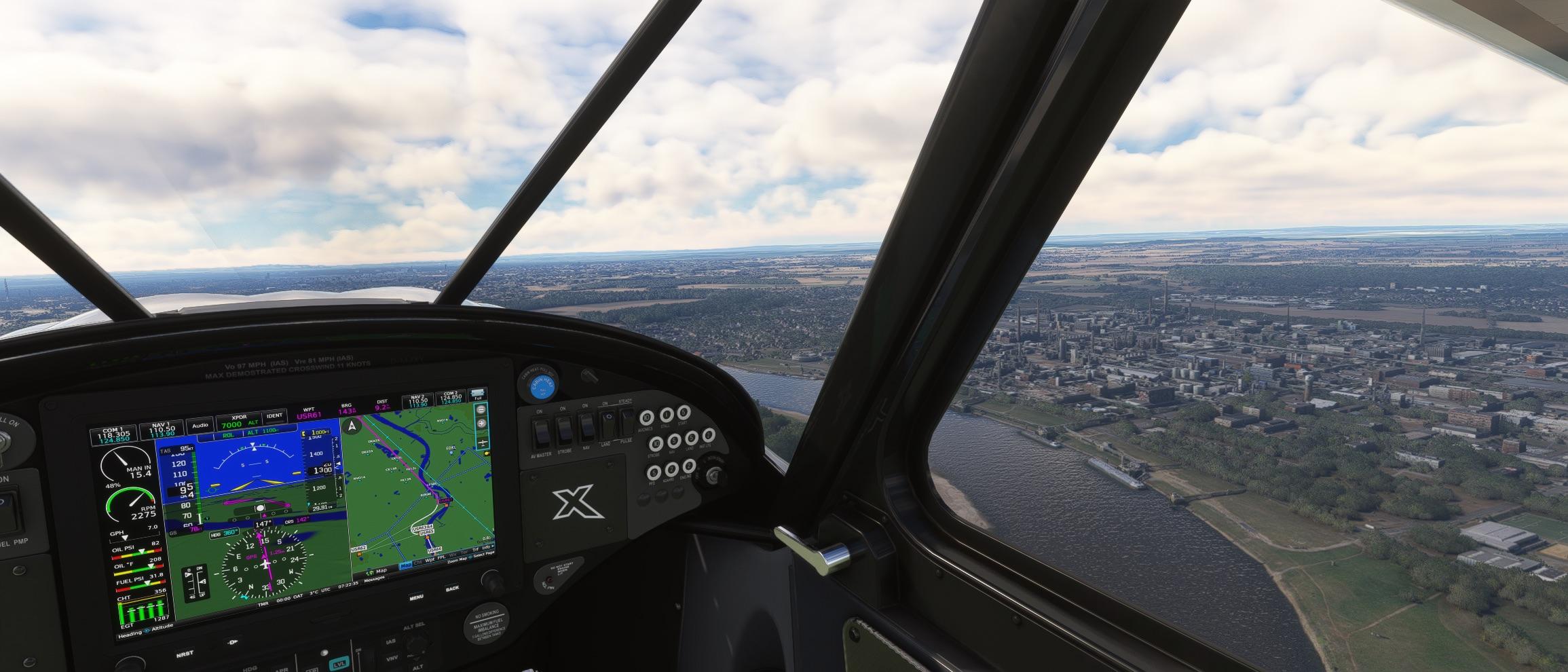
Koblenz-Winningen EDRK → Frankfurt EDDF

, , , , , .

The image depicts an aerial view of a small town or village surrounded by lush greenery and a river. The town is densely packed with buildings, and the river meanders through the landscape, dividing the town into different sections. The terrain appears to be hilly, with patches of forested areas and open fields visible. In the foreground, there is a small airplane flying over the town, with the registration number "D-MJXY" visible on its side. The overall scene suggests a serene and picturesque rural setting, possibly captured from a flight simulation or a real-life aerial photograph.The image depicts an aerial view of a landscape featuring a small aircraft flying over a rural area. The terrain below is characterized by a patchwork of fields, likely used for agriculture, with some areas appearing to be vineyards due to the grid-like patterns. The fields are interspersed with patches of greenery, possibly trees or bushes, and there are some buildings and structures visible in the bottom right corner, suggesting the presence of a small settlement or village.

The aircraft is a single-engine, low-wing plane with a red and white color scheme. It is flying at a moderate altitude, and the surrounding environment appears to be foggy or overcast, as the visibility is somewhat reduced, and the landscape has a muted appearance.

The overall scene suggests a peaceful, rural setting, possibly in a European country, given the style of the fields and the architecture of the buildings. The image could be from a flight simulation game or a real-life aerial photograph.The image depicts a scene from a flight simulation, likely from a flight simulation software such as Microsoft Flight Simulator or a similar program. The image shows a small aircraft flying over a cityscape with a river running through it. The aircraft appears to be a vintage or classic-style plane, possibly a biplane, with a single engine and a propeller at the front. The city below is densely populated with buildings, roads, and green spaces, and there is a bridge visible over the river. The overall atmosphere of the image suggests a cloudy or overcast day, as the lighting is somewhat dim and the colors are muted. The image captures the essence of flying over an urban area, providing a realistic view of what it might look like from the cockpit of a small aircraft.The image depicts a scene from a flight simulation, likely from a flight simulation software such as Microsoft Flight Simulator. The aircraft in the image is a biplane, which is a type of aircraft with two sets of wings, one above the other. The biplane is flying over a detailed urban landscape, which includes a mix of residential and commercial buildings, a river, and various roads and railways. The sky appears overcast, with a grayish tone, suggesting cloudy weather conditions. The overall scene is quite realistic, with attention to detail in the cityscape and the aircraft's design. The image captures the perspective of the pilot or the person flying the aircraft, providing a view of the city below and the surrounding environment.
Marcus Jaschenmjaschen
2025-12-03

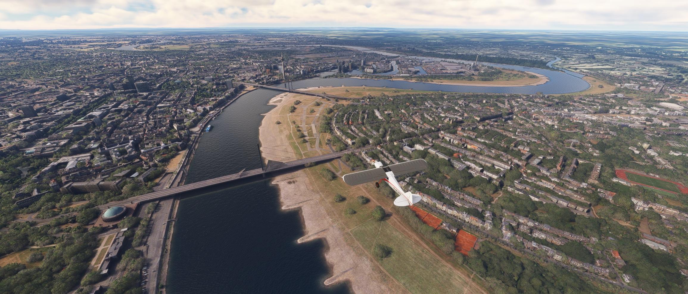
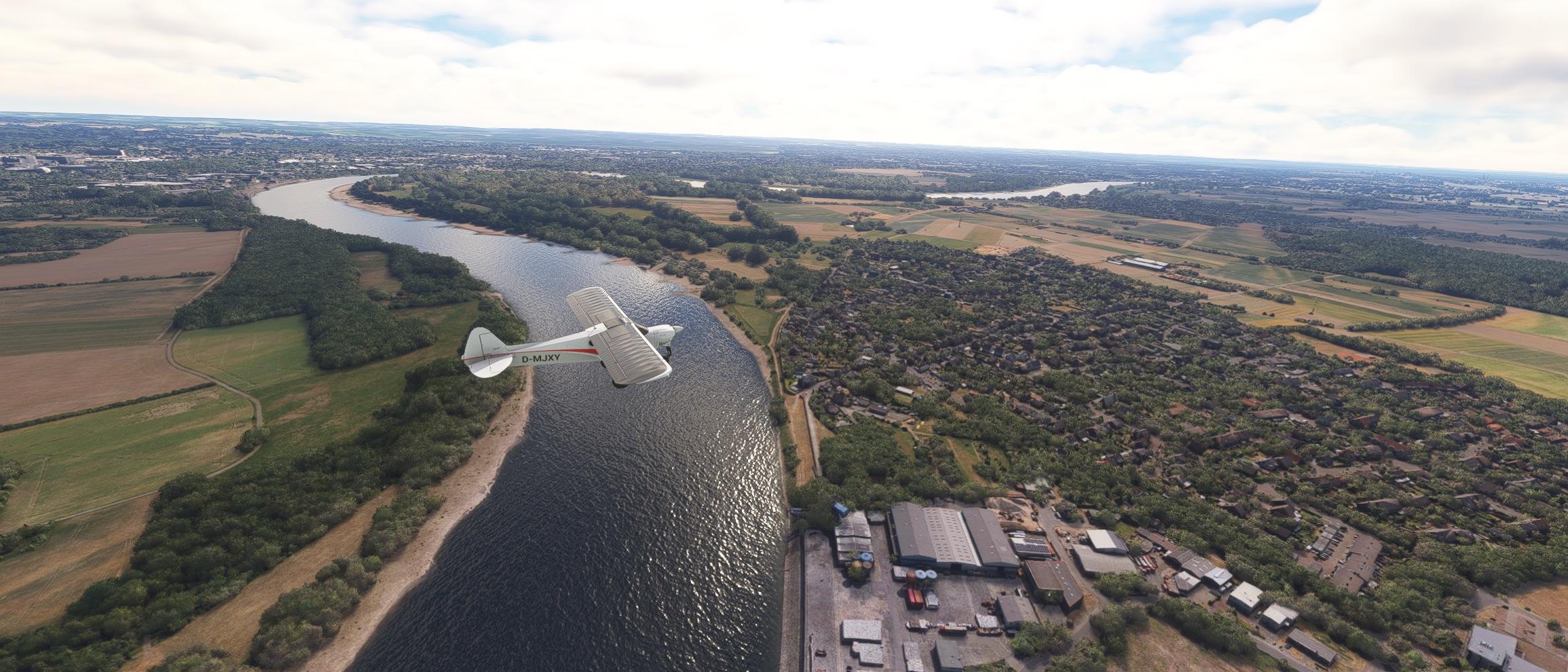
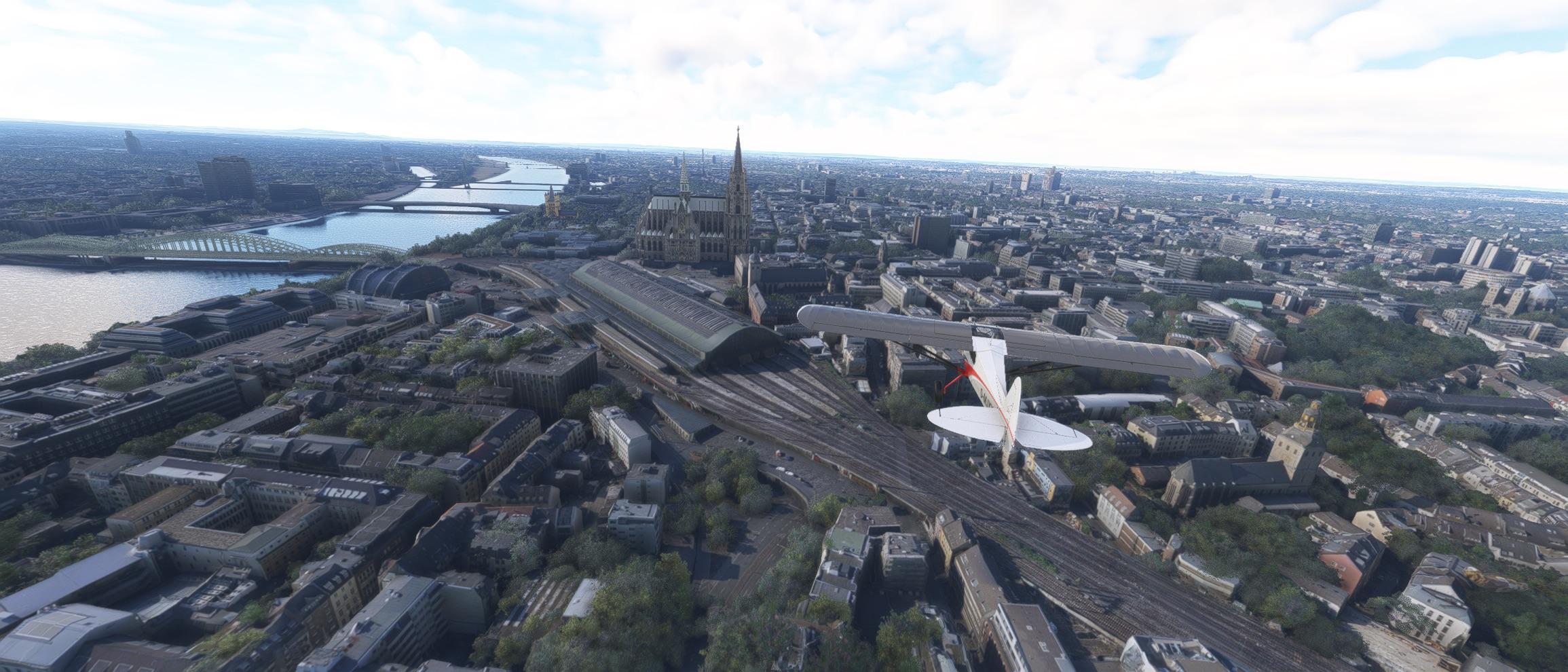
Köln/Bonn EDDK → Koblenz-Winningen EDRK

Nur echt mit Ozean-tauglichem Kreuzfahrtschiff am Deutschen Eck in Koblenz.

The image depicts an aerial view of a landscape with a small aircraft flying over a forested area. The terrain is predominantly green, indicating a dense forest, with some clearings and possibly agricultural fields visible. In the background, there is a larger area that appears to be an airport or airfield, with runways and various structures visible. The airport is surrounded by more developed land, including buildings and roads, which contrasts with the natural environment of the forest. The sky is clear and blue, suggesting a sunny day with good visibility. The overall scene suggests a rural or semi-rural setting where the airport is situated near a forested area.The image appears to be an aerial view of a landscape featuring a mix of natural and urban elements. Here's a detailed description:

1. **Foreground**:
   - A dense forest occupies a significant portion of the image, covering a large area on the right side.
   - There is a small, distinct structure visible within the forest, which could be a building or a monument, possibly a temple or a historical site, given its elevated position and the surrounding greenery.

2. **Midground**:
   - To the left of the forest, there is a road or highway that runs parallel to a body of water, which could be a river or a lake.
   - The road is bordered by what appears to be a developed area with buildings and possibly some agricultural fields or open land.

3. **Background**:
   - The left side of the image shows a more urban area with a dense concentration of buildings, suggesting a city or town.
   - The buildings are closely packed together, indicating a high population density.

4. **Airplane**:
   - In the bottom right corner of the image, there is a small airplane flying over the forest. The airplane appears to be a biplane, which is a type of aircraft with two sets of wings, one above the other.

The overall scene suggests a mix of natural and urban environments, with the forest and the airplane adding a dynamic element to the otherwise static landscape. The image could be from a simulation or a real-world aerial photograph.The image depicts an aerial view of a landscape from a high altitude, likely taken from a small aircraft. The scene includes a river winding through the terrain, surrounded by a mix of urban and rural areas. The river appears dark blue, contrasting with the lighter colors of the land. The urban areas are densely packed with buildings, roads, and green spaces, while the rural areas consist of fields, forests, and open land. The sky is clear and bright, indicating a sunny day with good visibility. The overall scene suggests a view from a flight simulator or a real-world aerial photograph.The image depicts a detailed aerial view of a cityscape, likely rendered in a high-fidelity 3D environment, possibly from a flight simulation game or a digital rendering software. The scene includes a river that meanders through the city, with bridges crossing over it. The city is surrounded by greenery, including forests and parks, which contrast with the urban structures. The sky is partly cloudy, with a mix of sunlight and shadow, giving the scene a realistic and dynamic appearance. A small aircraft is visible in the foreground, suggesting that the image might be from a flight simulation game where the player is flying over the city. The overall quality and detail suggest that this is a sophisticated digital creation, designed to mimic real-world environments.
Marcus Jaschenmjaschen
2025-12-02

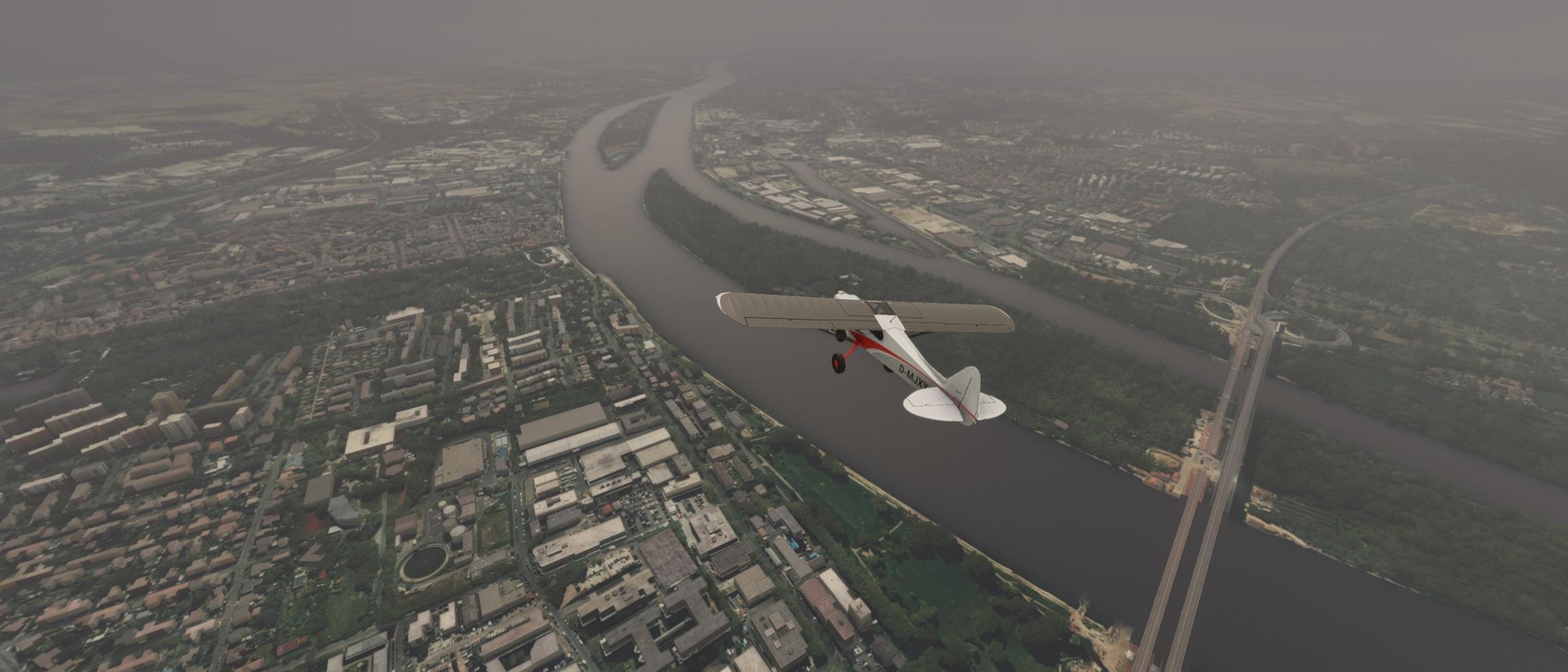
Düsseldorf EDDL → Köln/Bonn EDDK

Jetzt geht es den Rhein stromaufwärts und es gibt weiterhin viel zu entdecken.

The image depicts an aerial view of a cityscape, likely captured from a flight simulation or a high-resolution satellite image. The scene includes a river running through the center of the image, with a bridge spanning across it. The river is surrounded by greenery and urban development, with buildings and roads visible on both sides. In the foreground, there is a small aircraft flying over the river, adding a dynamic element to the image. The sky is partly cloudy, and the overall scene is well-lit, suggesting it is daytime. The image provides a detailed view of the urban environment, including residential areas, commercial buildings, and natural landscapes.The image depicts a view from inside a cockpit of an aircraft, likely a small private plane, as seen from the perspective of the pilot or a passenger. The cockpit is equipped with modern avionics, including a digital display panel that shows various flight instruments and navigation data. The display includes information such as airspeed, altitude, heading, and other flight parameters. The outside view through the cockpit window shows a landscape with a river, fields, and a cityscape in the distance. The sky is partly cloudy, suggesting a clear day with some scattered clouds. The overall scene suggests that the aircraft is in flight, possibly over a rural or semi-urban area. The image appears to be from a flight simulation software, as indicated by the detailed and realistic graphics.The image depicts an aerial view of a landscape featuring a small airplane flying over a river and a town. The airplane is a CubCrafters NXCub with the registration number "D-MJXY" visible on its side. The river curves through the landscape, bordered by green vegetation and fields. On the right side of the image, there is a town with buildings and industrial structures, including what appears to be a large warehouse or factory. The sky is partly cloudy, and the overall scene suggests a peaceful, rural setting with a mix of natural and developed areas. The image appears to be a screenshot from a flight simulation game, given the detailed rendering of the environment and the airplane.The image depicts an aerial view of a cityscape, likely taken from a simulation or a video game due to the high level of detail and the presence of a small aircraft in the foreground. The city features a prominent cathedral with a tall spire, which is a distinctive landmark. The cathedral is situated near a river, with bridges crossing over it. The surrounding area includes a mix of modern and older buildings, with some green spaces and trees interspersed throughout the urban environment. The sky is partly cloudy, suggesting a bright day. The overall scene is detailed and realistic, capturing the essence of a large, bustling city.
Marcus Jaschenmjaschen
2025-12-01

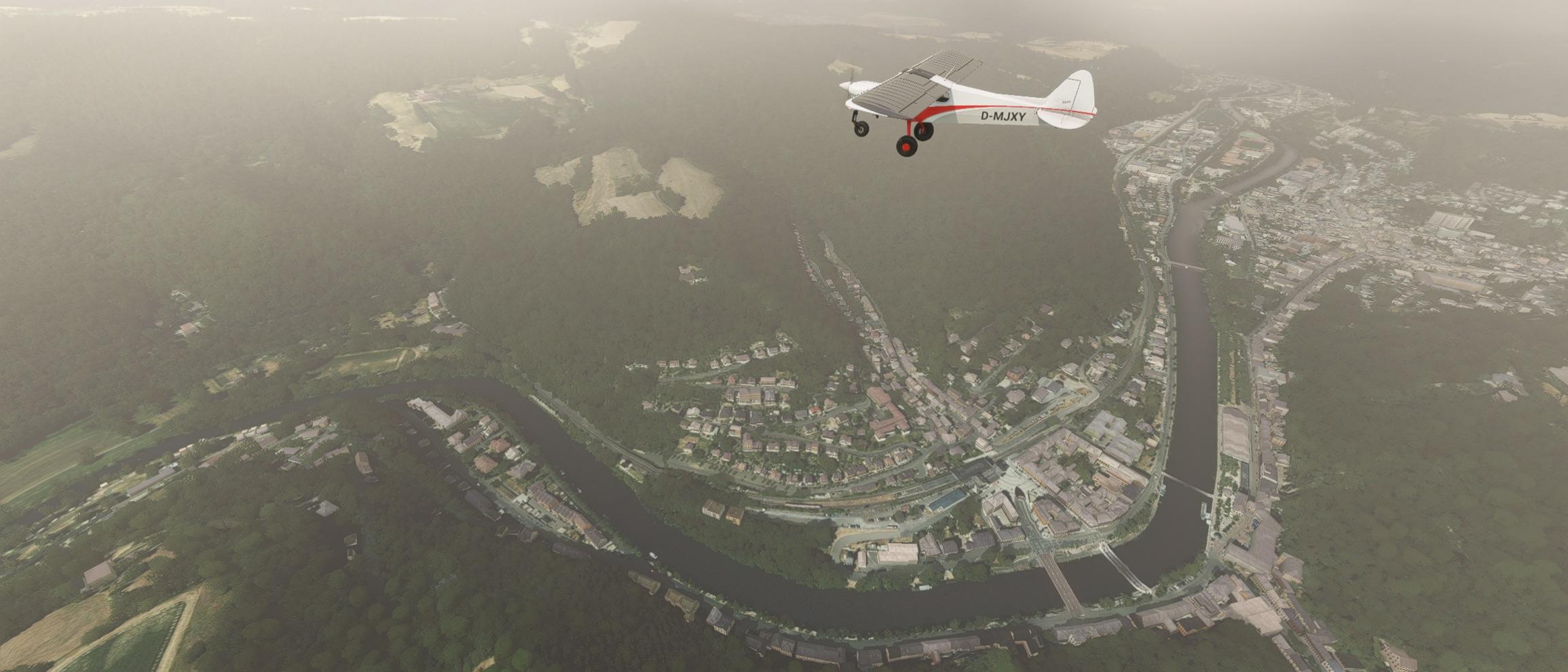
Kamen-Heeren → Düsseldorf EDDL

Rund ums Ruhrgebiet gibt es richtig viel zu sehen. Tolle Route.

The image depicts an aerial view of a cityscape, likely captured from a flight simulation or a video game. The scene shows a mix of urban and rural areas, with a prominent stadium visible in the lower left portion of the image. The stadium has a distinctive roof structure, which is characteristic of certain sports venues. Surrounding the stadium are various buildings, roads, and green spaces, indicating a well-developed urban area.

In the foreground, there is a small aircraft flying over the city. The aircraft appears to be a biplane, which is a type of aircraft with two sets of wings, one above the other. The biplane is flying at a low altitude, suggesting it might be part of a flight simulation or a scene from a video game where the player is flying over a city.

The background of the image shows a vast expanse of land with fields, forests, and possibly some industrial areas, indicating a transition from the urban environment to more rural or suburban areas. The sky is clear with a few clouds, suggesting good weather conditions.

Overall, the image captures a dynamic scene of a city from an aerial perspective, with a focus on both the urban infrastructure and the surrounding landscape.The image appears to be a screenshot from a flight simulation game, likely Microsoft Flight Simulator, given the high level of detail and the style of the graphics. The scene shows an aerial view of a city and its surrounding areas.

In the foreground, there is a small aircraft flying towards the viewer. The aircraft is a single-engine plane, a CubCrafters NXCub, and it is flying at a low altitude.

The landscape below includes a mix of urban and rural areas. There are several large green fields, which could be sports fields or agricultural land, and a large white dome-shaped structure that resembles a stadium or sports arena. The cityscape includes a variety of buildings, roads, and green spaces, with a river or canal visible in the middle of the image.

The overall scene is detailed and realistic, with a focus on the urban and suburban environment. The image captures the essence of a flight over a modern city with its mix of natural and built environments.The image depicts a view from inside an aircraft, specifically from the cockpit. The perspective is from the pilot's seat, looking out through the windshield. The cockpit instruments are visible at the bottom of the image, including various gauges and displays. The view outside the aircraft shows a clear blue sky and a landscape below, which includes a large industrial area with factories and a body of water, possibly a river or lake. The terrain is mostly flat with some greenery and open spaces. The overall scene suggests that the aircraft is flying at a high altitude, providing a broad view of the landscape below.The image depicts an aerial view of a landscape featuring a small aircraft flying over a river and industrial areas. The river runs through the center of the image, dividing the scene into two parts. On the left side, there is a large industrial complex with various buildings and structures, possibly a factory or a mining facility, characterized by its earthy tones and industrial appearance. On the right side, there is a more rural area with green fields, trees, and what appears to be a residential or suburban area with houses and roads.

The sky is clear and blue, indicating a sunny day with good visibility. The aircraft in the foreground is a small, single-engine plane with a white body and red accents, flying at a moderate altitude. The overall scene suggests a mix of industrial and natural landscapes, with the river acting as a dividing line between the two. The image appears to be taken from a simulation or a video game, given the high level of detail and the realistic rendering of the environment.
Ian Kluft ✅✈️🎈🌋ikluft@avgeek.social
2025-11-09

"Carbon Cub UL climbs above altitude record" by AOPA - Alaskan pilot Jon Kotwicki set an unofficial altitude record of 37,609ft (11463m) in a Carbon Cub UL on a flight out of San Luis Obispo #KSBP California. Carbon Cubs by #CubCrafters of Yakima WA are descendants of the Piper PA-18 Super Cub, redesigned in carbon fiber. The altitude-record plane is equipped with a turbocharger. The previous highest-known altitude for any Cub was 30,200ft. aopa.org/news-and-media/all-ne #aviation #pilot #avgeek

article overview screenshot

AOPA - Aircraft Owners and Pilots Association

Carbon Cub UL climbs above altitude record
'Climb and maintain Three-Five-Zero'
October 31, 2025 By Dave Hirschman

A stock, Rotax-powered Carbon Cub UL set an unofficial altitude record of 37,609 feet over the Pacific Ocean near Central California on October 28.

photo caption: Jon Kotwicki at 37,609 feet, the unofficial new service ceiling for the Carbon Cub UL. Photo courtesy of CubCrafters.

The airplane, N14UL, was flown by Alaska pilot Jon Kotwicki and climbed for 62 minutes to where the outside air temperature was minus 51 degrees Fahrenheit.

The turbocharged, 160-horsepower Rotax 916iS engine was operating at 100 percent power and turning 5,826 rpm at 23.2 inches of manifold pressure when the airplane topped out at a pressure altitude of 35,720 feet. Its indicated airspeed was 61 knots (113 knots true airspeed) at the top of the climb.

[...]
Aerobuzz / JumpSeataerobuzz@piaille.fr
2025-02-26

La nouvelle gamme d'hélices en matériaux composites Falcon de Harzell intègre l'hélice tripale Kestrel. LPesant 8,6 kg, elle fait gagner 4 kts en croisière au Carbon Cub UL avec moteur Rotax 916.
#Hartzell #Rotax #CubCrafters #helice

aerobuzz.fr/breves-aviation-ge

Client Info

Server: https://mastodon.social
Version: 2025.07
Repository: https://github.com/cyevgeniy/lmst