
Aug 24 4:20PM EDT: Update on #99L @53rdWRS data indicate that the system located near the Windward Islands does not have a closed low-level circulation. However, the system is still producing a large area of showers and thunderstorms and winds to near gale force. These… https://x.com/NHC_Atlantic/status/1959713557836366079
#99L


Invest #99L is likely to become #Sara in the next couple days. It poses a major flooding threat to Honduras, as it will stall out near the coast. What Florida sees next week will depend heavily on where that stall occurs in a few days. We explain: https://theeyewall.com/sara-should-soon-form-a-significant-late-season-threat-to-honduras-in-particular-and-something-for-florida-to-monitor-closely/


Invest #99L has been designated in the central Caribbean Sea. It currently has a high chance of becoming a tropical depression.
Even this late in the season, conditions are favorable for development. The system could strengthen further as it shifts northwest by early next week.

#99L has been declared. Most likely thing for Hurricane #Sara to do is loop-de-loop, so don't worry about direction until after Sunday/Monday.
Invest #99L has been designated in the western Atlantic Ocean. It has a low chance of organizing into a tropical depression in the next 7 days.
See the latest details here: https://zoom.earth/storms/99l-2024/?date=2024-09-25
Invest #99L has been designated near the U.S. East Coast. It has a low chance of organizing into a tropical depression in the next 7 days.
Follow updates here: https://zoom.earth/storms/99l-2024/?date=2024-09-05
#99L in Caribbean drying up. May bring some rain to Central America this weekend.
Area in central Atlantic 60% for (sub)tropical system as eventually curves up towards The Azores this weekend.
#94e East Pacific far from land.
Hurricane season coming to a close.
21Nov2023
Invest #99L has been designated in the Caribbean Sea. It has a low chance of forming into a tropical depression in the next 7 days.
More details here: https://zoom.earth/storms/99l-2023/?date=2023-11-20
If you look at the SST, the cool pool from #Lee/#Nigel is pretty far east of this track. More likely #99L/#PTC16 gets a boost from the Gulf Stream than suffers a loss from cool pool.
Although also as shown here: 7-day SST trend. Once it passes Gulf Stream, all downhill from there. Green = ~normal.

The system off the Florida coast has now been designated Invest 99L.
If it organizes & becomes a subtropical storm, it will be named #Ophelia.
Regardless of name or PTC designation, it will likely be a wet & windy start to the weekend for ENC.
Invest #99L has been tagged 280 miles east of the Florida peninsula. It could develop into a subtropical cyclone and bring tropical storm-force winds and heavy rain to the mid-Atlantic U.S. by late Friday. #Invest99L #weather #WX
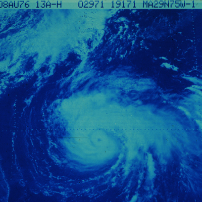
This morning’s satellite picture of Invest #99L north of the Bahamas. It has a medium chance (50%) of organizing into a subtropical depression within 48 hours. #Invest99L #weather #WX
Invest #99L has been designated north of the Bahamas.
Latest details here: https://zoom.earth/storms/99l-2023/
Invest #99L has become Tropical Depression Six #TD6. But it's facing wind shear and running into a plume of dry dusty air (SAL). Not expected to last long.
19Aug2023
(4/7)
New satellite view of disturbance #99L in the central Atlantic Ocean. This system has a medium chance (40%) of forming into a tropical depression in the next 48 hours. #Invest99L #weather #WX
Invest #99L satellite picture from today in the central Atlantic Ocean. There is now a medium chance (40%) this system will become a tropical depression in the next 2 days. #Invest99L #weather #WX
Disturbance #99L has been designated in the central Atlantic Ocean.
Latest updates here: https://zoom.earth/storms/99l-2023/?date=2023-08-17

In today's video we take a quick look at #99L a significant disturbance that models indicated could develop into a dangerous Gulf of Mexico hurricane #YouStormOutlook https://youtu.be/rCNyWjYOSjA
One of the better looking invests out there in the North Atlantic in #99L Maybe a trip to Portugal in its future.pic.twitter.com/BDNQYzxFzW https://twitter.com/JimCantore/status/1189087536754450432 Published at Tue, 29 Oct 2019 07:52:15 +0000
Client Info
Server: https://mastodon.social
Version: 2025.07
Repository: https://github.com/cyevgeniy/lmst