
Fra Mauro 1450 map of Ireland (and the world)
#100daysofmaps #day100 #ireland
It has city of Ross, Dungarvan, Lanere (limerick?), ate (Athlone?) and Strangford
#100daysofmaps


Coal Fields of Ireland map 1920 #100daysofmaps #day99 #ireland

Live Airplane tracker over Ireland #100daysofmaps #day98 #ireland


Where Woodpeckers are found in Ireland
#100daysofmaps #day97 #ireland source which has lots of other animalshttps://biodiversityireland.ie/great-spotted-woodpecker-continues-its-remarkable-spread-in-ireland/

Live Shipping Map of Ireland
#100daysofmaps #day96 #ireland source
http://www.shiptraffic.net/marine-traffic/seas/Irish_Sea


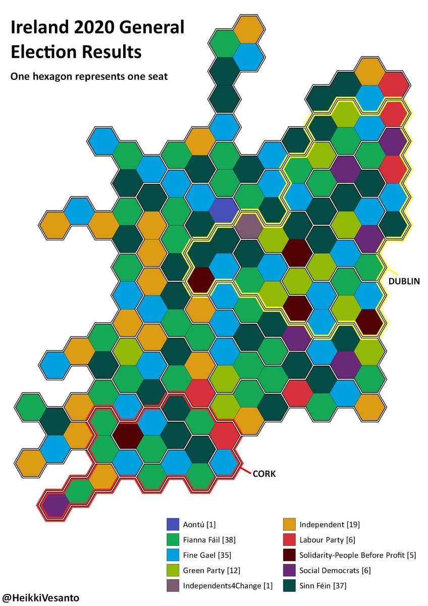
#GE2020 Ireland 2020 Election Results. Hex map of results by
HeikkiVesanto #100daysofmaps #day93


Map of the provinces of Ireland by Joan Blaeu 1650's and 1660s #100daysofmaps #day91


Ireland bathy-orographical map 1920 #100daysofmaps #day90 source https://maps.nls.uk/view/101105611#zoom=4&lat=4664&lon=3631&layers=BT

Topographia Hiberniae by Gerald of Wales around 1188 #100daysofmaps #day89 https://en.wikipedia.org/wiki/Topographia_Hibernica
Bearded LAdies, kissing goats this book has it all


Land Ownership in Ireland 1641 and 1703 #100daysofmaps #day88

Dymaxion Map of Ireland and the world. Source https://en.wikipedia.org/wiki/Dymaxion_map #100daysofmaps #day87


Number of words in each counties Wikipedia articles. Source https://www.reddit.com/r/dataisbeautiful/comments/189roov/number_of_words_in_each_irish_countys_wikipedia/ #100daysofmaps #day86

Sile ne gigs of Ireland source https://www.heritagemaps.ie/WebApps/HeritageMaps/index.html #100daysofmaps #day85

Wealth in 14th Century Ireland #100daysofmaps #day83 source https://www.thejournal.ie/wealth-in-ireland-1300-4146574-Jul2018/

320 border road crossings between #Ireland and #NorthernIreland made by Conor Graham #100daysofmaps #day81

Beaufort 1792 ecclesiastical map of Ireland. Source https://www.loc.gov/resource/g5781f.ct000402/?r=-0.87,0.134,2.741,1.073,0 #100daysofmaps #day80 This one is worth zooming into

Home Rule Map of Ireland 1893. source https://www.loc.gov/resource/g5781f.ct000405/?r=-1.088,0.221,3.175,1.244,0
#100daysofmaps #day79

Client Info
Server: https://mastodon.social
Version: 2025.07
Repository: https://github.com/cyevgeniy/lmst