A very detailed shaded map of Toronto, Canada. The full map is 19720 x 19720 pixels with 0.5 m resolution and is available at https://shadedmaps.github.io
Data source: https://open.canada.ca [Natural Resources Canada].
#geography #shadedrelief #maps #shadedmaps #lidar

Shaded Maps
Digitally manufacturing detailed shaded city maps with Python, PDAL and GDAL tools from LiDAR, DSM and OSM data!


A very detailed shaded map of Honolulu, Hawaii, US. The full map is 20000 x 20000 pixels with 0.5 m resolution and is available at https://shadedmaps.github.io
Data source: https://apps.nationalmap.gov [U.S. Geological Survey, National Geospatial Program].
#GIS #maps #geography #lidar #shadedrelief


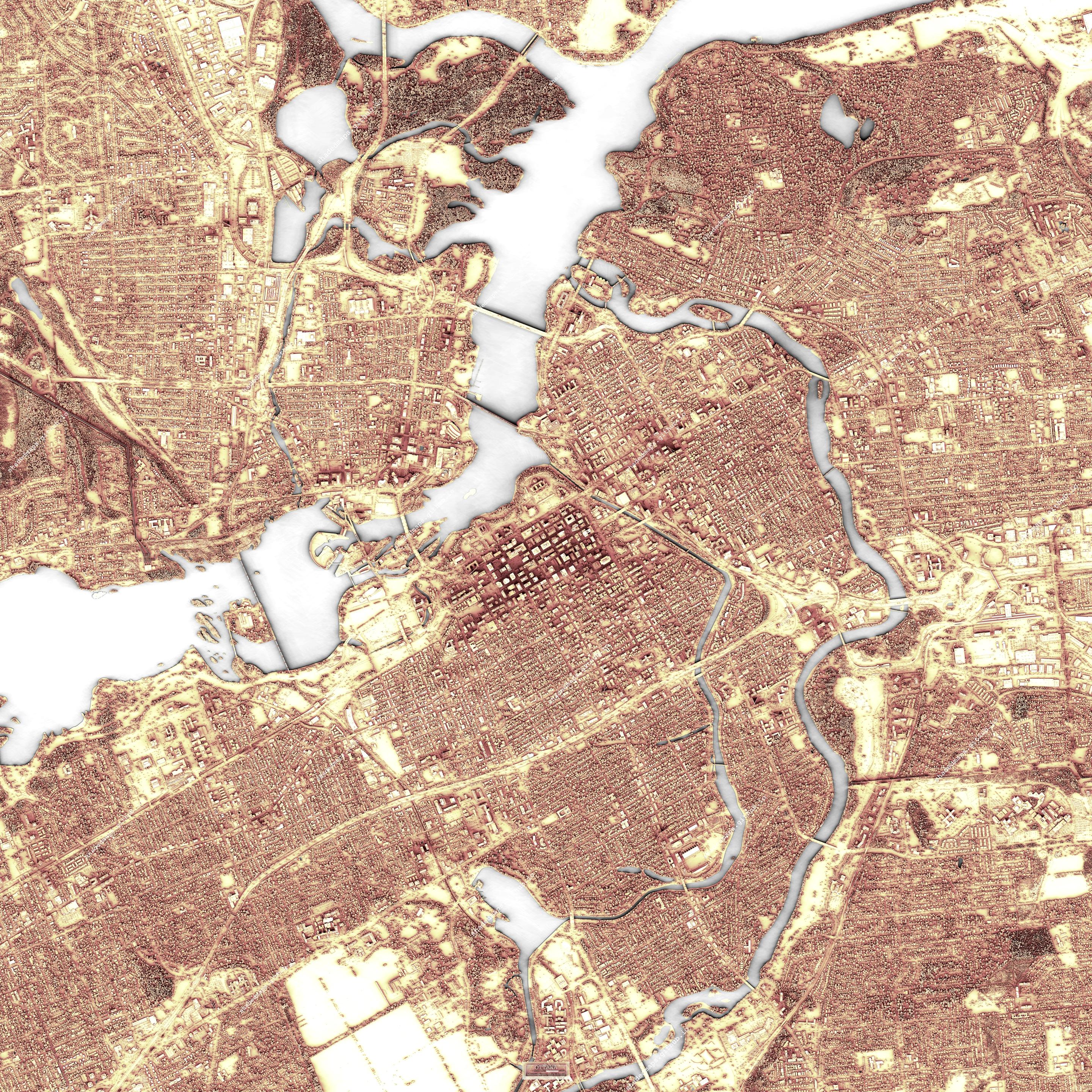
A very detailed shaded map of Ottawa, Canada. The full map is 17500 x 17500 pixels with 0.5 m resolution and is available at https://shadedmaps.github.io
Data source: https://open.canada.ca [Natural Resources Canada].
#shadedmaps #gischat #dataviz #lidar #shadedrelief


A very detailed shaded map of Milano, Italy. The full map is 12000 x 12000 pixels with 1 m resolution and is available at https://shadedmaps.github.io
Data source: https://gisportal.comune.milano.it [Comune di Milano].
#lidar #GIS #geography #gischat #shadedrelief


@Earl yep, and on the other hand other governments, e.g. the French one, completely remove the point clouds from the areas corresponding to military and government buildings, prisons, and so on
A very detailed shaded map of Las Vegas, Nevada, US. The full map is 40000 x 40000 pixels with 1 ft resolution and is available at https://shadedmaps.github.io
Data source: https://apps.nationalmap.gov [U.S. Geological Survey, National Geospatial Program].
#shadedmaps #lidar #maps #geography #dataviz


A very detailed shaded map of Washington, District of Columbia, US. The full map is 20000 x 20000 pixels with 0.5 m resolution and is available at https://shadedmaps.github.io
Data source: https://apps.nationalmap.gov [U.S. Geological Survey, National Geospatial Program].
#GIS #dataviz #shadedmaps #lidar #cartography


@JensWiesehahn Hi Jens, I believe my approach is similar to "time_in_daylight", which I don't really know enough about. Anyway, my code is mostly Python except the most computationally intensive part of calculating the shadows on each pixel of the DSM for about 250-300 position of the sun in the sky. Ultimately, the "darkness" of a pixel should be proportional to the time spent in the shade when sunlight is present.
A very detailed shaded map of Saint Louis, Missouri, US. The full map is 20000 x 20000 pixels with 0.75 m resolution and is available at https://shadedmaps.github.io
Data source: https://apps.nationalmap.gov [U.S. Geological Survey, National Geospatial Program].
#maps #GIS #shadedmaps #cartography #dataviz


A very detailed shaded map of Porto, Portugal. The full map is 20000 x 20000 pixels with 0.5 m resolution and is available at https://shadedmaps.github.io
Data source: https://cdd.dgterritorio.gov.pt [Direção-Geral do Território].
#maps #GIS #dataviz #shadedmaps #lidar


@stevefaeembra I thought it was Iceland!
@jeremy thanks! And thanks to you for this map-dedicated space ;-)
A very detailed shaded map of New York City [Financial District], New York, US. The full map is 20000 x 20000 pixels with 1 ft resolution and is available at https://shadedmaps.github.io
Data source: https://gis.ny.gov [NYC Office of Technology and Innovation (OTI)].
#shadedmaps #gischat #cartography #GIS #dataviz
![Resized shaded map of New York City [Financial District], New York, US.](https://files.mastodon.social/cache/media_attachments/files/115/939/620/844/389/072/original/3091bfb7de8bcf72.jpg)
![A fragment from the shaded map New York City [Financial District], New York, US.](https://files.mastodon.social/cache/media_attachments/files/115/939/620/881/843/059/original/85bdec698257f0d3.jpg)
![A fragment from the shaded map New York City [Financial District], New York, US.](https://files.mastodon.social/cache/media_attachments/files/115/939/620/913/426/912/original/0d5dcb787d4d1f4a.jpg)

Client Info
Server: https://mastodon.social
Version: 2025.07
Repository: https://github.com/cyevgeniy/lmst