
#wildfires #firewx #CAwx
LEVEL Internal - Shelter in Place EVACUATION
County: San Diego
Zone ID:SDC-1418
Advice: Internal - Shelter in Place
Posted:2026-02-26 13:28 PST
To check for an updated map: https://protect.genasys.com/zones/US-CA-XSD-SDC-1418
***EXPERIMENTAL DO NOT RELY ON FOR LIFE SAFETY***
#FireWx


#NIFC #wildfires #firewx
NIFC New Or Updated Wildfire Perimeter
Incident Name: 113 Incident
Acres: 5125.6 acres
Updated: Feb 26, 2026 18:25 UTC
Source: IRWIN
#113IncidentFire #COwx


NICC Day 3 Significant Fire Potential #NIFC #NICC #wildfires #firewx

NICC Day 2 Significant Fire Potential #NIFC #NICC #wildfires #firewx

NICC Day 1 Significant Fire Potential #NIFC #NICC #wildfires #firewx

#wildfires #firewx #CAwx
LEVEL Internal - Advisory EVACUATION
County: San Diego
Zone ID:SDC-1417
Advice: Internal - Advisory
Posted:2026-02-26 03:40 PST
To check for an updated map: https://protect.genasys.com/zones/US-CA-XSD-SDC-1417
***EXPERIMENTAL DO NOT RELY ON FOR LIFE SAFETY***

#NIFC #wildfires #firewx
NIFC New Or Updated Wildfire Perimeter
Incident Name: RX BEAR CREEK
Acres: 863.6 acres
Updated: Feb 26, 2026 02:40 UTC
Source: IRWIN
#RXBEARCREEKFire #OKwx

#NIFC #wildfires #firewx
NIFC New Or Updated Wildfire Perimeter
Incident Name: Cypress Creek
Acres: 6827.9 acres
Updated: Feb 26, 2026 00:07 UTC
Source: IRWIN
#CypressCreekFire #TXwx

#NIFC #wildfires #firewx
NIFC New Or Updated Wildfire Perimeter
Incident Name: Coal
Acres: 20.0 acres
Updated: Feb 25, 2026 18:12 UTC
Source: IRWIN
#CoalFire #ILwx

#NIFC #wildfires #firewx
NIFC New Or Updated Wildfire Perimeter
Incident Name: River Boat
Acres: 3.2 acres
Updated: Feb 25, 2026 19:26 UTC
Source: IRWIN
#RiverBoatFire #TXwx

#NIFC #wildfires #firewx
NIFC New Or Updated Wildfire Perimeter
Incident Name: Nebo Mountain
Acres: 1160.0 acres
Updated: Feb 25, 2026 14:09 UTC
Source: IRWIN
#NeboMountainFire #TXwx

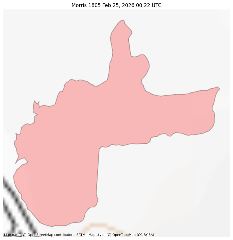
#NIFC #wildfires #firewx
NIFC New Or Updated Wildfire Perimeter
Incident Name: Morris 1805
Acres: 5.3 acres
Updated: Feb 25, 2026 00:22 UTC
Source: IRWIN
#Morris1805Fire #TXwx
#NIFC #wildfires #firewx
NIFC New Or Updated Wildfire Perimeter
Incident Name: Camp 1796
Acres: 4.5 acres
Updated: Feb 25, 2026 00:23 UTC
Source: IRWIN
#Camp1796Fire #TXwx

#NIFC #wildfires #firewx
NIFC New Or Updated Wildfire Perimeter
Incident Name: Anderson 1804
Acres: 2.6 acres
Updated: Feb 24, 2026 22:36 UTC
Source: IRWIN
#Anderson1804Fire #TXwx

#NIFC #wildfires #firewx
NIFC New Or Updated Wildfire Perimeter
Incident Name: Tyler 1795
Acres: 29.8 acres
Updated: Feb 24, 2026 20:56 UTC
Source: IRWIN
#Tyler1795Fire #TXwx

#NIFC #wildfires #firewx
NIFC New Or Updated Wildfire Perimeter
Incident Name: Hidalgo 1675
Acres: 62.0 acres
Updated: Feb 24, 2026 19:38 UTC
Source: IRWIN
#Hidalgo1675Fire #TXwx

#NIFC #wildfires #firewx
NIFC New Or Updated Wildfire Perimeter
Incident Name: RX North Blue
Acres: 2054.6 acres
Updated: Feb 24, 2026 03:32 UTC
Source: IRWIN
#RXNorthBlueFire #OKwx

#NIFC #wildfires #firewx
NIFC New Or Updated Wildfire Perimeter
Incident Name: National Fire
Acres: 25780.1 acres
Updated: Feb 25, 2026 23:38 UTC
Source: IRWIN
#NationalFireFire #FLwx

#NIFC #wildfires #firewx
NIFC New Or Updated Wildfire Perimeter
Incident Name: Cypress Creek
Acres: 1141.6 acres
Updated: Feb 25, 2026 18:20 UTC
Source: IRWIN
#CypressCreekFire #TXwx

#NIFC #wildfires #firewx
NIFC New Or Updated Wildfire Perimeter
Incident Name: Coal
Acres: 20.0 acres
Updated: Feb 25, 2026 18:12 UTC
Source: IRWIN
#CoalFire #ILwx

Client Info
Server: https://mastodon.social
Version: 2025.07
Repository: https://github.com/cyevgeniy/lmst